
Carpenter Hill Power · Charlton, Massachusetts · 980 CMR 15.00
Cumulative Impact Analysis
Whether the project adds to the burdens the host block group already carries: the Specific Geographical Area, the Burdened Area it intersects, the 16 Elevated Indicators, and the project's effect on each.
This is the preliminary draft the project shares with Key Stakeholders during pre-filing under 980 CMR 15.03(6). Every determination in it is preliminary and says what it depends on. The final CIA Report is filed with the Application, expected in early 2027, and every version of this report stays published.
Carpenter Hill Power, LLC. Docket: Not yet assigned (pre-filing). Prepared by Wes Shaffer, AICP, Director of Planning and Engagement, ESA Solar, on behalf of Carpenter Hill Power, LLC. The live version, the slides and every document this report rests on are at carpenterhillpower.com/reports/cumulative-impact.
Contents
What is in this report
- 1Summary
- 2The Specific Geographical Area
- 3Burdened Areas intersecting the SGA
- 4Elevated Indicators
- 5Construction phase: project impacts on the Elevated Indicators
- 6Operations phase: project impacts on the Elevated Indicators
- 7Avoidance, minimization and mitigation
- 8Project benefits and the Community Benefits Plan
- 9Conclusion, and what would change it
- 10Community input, and how to take part
- 11Sources, methods and terms
Figures
- 1The facility boundary for the state suitability tool
- 2Parcel, leased work area and equipment area
- 3Project location and landmarks within one mile
- 4The Specific Geographical Area and the Burdened Area it intersects
- 5The site's block group, its MassEnviroScreen score and what drives it
- 6US grid battery fires since 2019 with a public record: cells, enclosure, public orders, and what sampling found
- 7Shelter and evacuation orders at US battery fires: how often, and how long, by battery type
- 8What reached the environment at real battery fires, by comparability
- 9Where the pad drains, where Gillespie Road drains, and the ridge between them
- 10Elevation from Gillespie Road through the pad to McIntyre Pond
- 11Which way the wind blows: ten years at Worcester Regional Airport
- 12What the land does to anything that leaves the pad, stage by stage
- 13Modeled sound sources on the current layout
- 14Receptors within one mile and the night-time contours
- 15Night typical case: preliminary screening before any fixes
- 16Mitigated equipment plus a 20 ft wall, a test case in the preliminary screening
- 17Terrain profiles to the four nearest houses
- 18What the 34 open decisions are about
- 19What is not known yet, and when it will be
What this report found
- The one-mile Specific Geographical Area intersects one Burdened Area, block group 250277561012, which scores 80.9 on MassEnviroScreen against a threshold of 75 and contains every component of the project.
- Sixteen of the block group's 29 scored indicators are Elevated Indicators. The score is carried by legacy contamination and impaired streams around the block group, none of it on the parcel.
- Preliminary finding: the project is not expected to materially exacerbate any Elevated Indicator in construction or operation, so no Disproportionate Adverse Effect is identified. The finding is conditional on the fire protection, sound and stormwater studies.
- The neighbouring block group, scoring 73.0, is analysed voluntarily, and residents of it can petition for a full analysis.
What a Cumulative Impact Analysis is, and what this one found so far
Summary
A Cumulative Impact Analysis asks one question in five steps: does this project add to burdens a community already carries? The site sits in a census block group the state has designated a Burdened Area, so every step applies. This working draft records the steps taken, the preliminary answer to each, and what still has to happen before the answer is final.
1 mile
Specific Geographical Area for a clean energy storage facility, measured from the 17.29-acre Facility Boundary
80.9
MassEnviroScreen score of the host block group. Burdened Area threshold: 75
16 of 29
Indicators above the 50th percentile in the host block group, so Elevated Indicators
Pending
Disproportionate Adverse Effect finding. Most indicators are a preliminary no. Wildfire risk, groundwater threats and the two noise-linked health indicators wait on open studies
The 2024 Climate Act requires an applicant for an energy facility to assess the existing environmental burdens and public health consequences in the area around a proposed site, and, where that area is subject to an unfair or inequitable burden, to identify any impact of the project that would likely result in a disproportionate adverse effect, any impact that would increase or reduce the effects of climate change, and the remedial actions proposed for either. 980 CMR 15.00 sets the method. The Office of Environmental Justice and Equity's Standards and Guidelines for Cumulative Impact Analysis, April 2026, sets the standard. This report follows the Board's CIA Report Template, part by part, so that the filed version can be checked against this one.
The five steps of 980 CMR 15.03, and where this analysis stands on each.
| Step | Rule | Result so far |
|---|---|---|
| 1. Identify the Specific Geographical Area | 15.05(1) | One mile from the 17.29-acre Facility Boundary. Section 2. |
| 2. Does it intersect a Burdened Area? | 15.04, 15.05(2) | Yes. Block group 250277561012, score 80.9. The analysis continues. Section 3. |
| 3. Which indicators are elevated? | 15.06 | Sixteen of 29. Section 4. |
| 4. Does the project materially exacerbate any of them? | 15.07 | Preliminary: no, in either phase. Conditional on the studies listed in Section 9. Sections 5 and 6. |
| 5. Remedial actions | 15.08 | None required by a finding. The firm commitments that keep the answer at no are listed anyway. Section 7. |
How to read this draft
This is the analysis 980 CMR 15.03(6) asks the project to share with Key Stakeholders during pre-filing. It is not the filed report. Every determination in Sections 5 and 6 is preliminary and says what it depends on. The state's own guidance says MassEnviroScreen is a starting point to be supplemented with community input and local information; Section 10 says what residents have told us and how to add to it.
CIA Report Template Part I; 980 CMR 15.05(1)
The Specific Geographical Area
The Specific Geographical Area, or SGA, is the ground the analysis examines. It is drawn as a fixed distance from the Facility Boundary, and the distance depends on the kind of facility. For a clean energy storage facility it is one mile.
Table 1. Proposed sites or routes.
| Site or route type | Address and description |
|---|---|
| Proposed | Assessor parcel 43-A-1, 131 Carpenter Hill Road, Charlton, Massachusetts, 47.13 acres, with a gen-tie easement extending about 1,142 feet beyond the parcel to the Carpenter Hill substation. A 136-unit lithium iron phosphate battery energy storage facility on a fenced pad inside a 15.26-acre leased work area, connecting to the substation through a 2,694-foot gen-tie. Full description in the Application. |
| Noticed alternative | None. The project proposes one site. |
| Noticed variation | None. |
Table 2. The Facility Boundary and how it meets the 980 CMR 15.02 definition.
| Site or route type | Map | Facility Boundary and compliance with the definition |
|---|---|---|
| Proposed | Figure 1 | One merged polygon of 17.29 acres measured from site plan G101 revision 16 (June 10, 2026): the 15.26-acre BESS project area, which is the outermost limit of construction activity and disturbance around the fenced pad; the 1.86-acre gen-tie easement, 2,694 feet by 30 feet, taken at the edge of the right of way as the definition requires for a linear component; and the 0.55-acre access driveway from Carpenter Hill Road, which is ground disturbance outside both. The title block on the plan reads 16.57 acres and leaves the driveway out; the larger, more inclusive boundary is used here. |
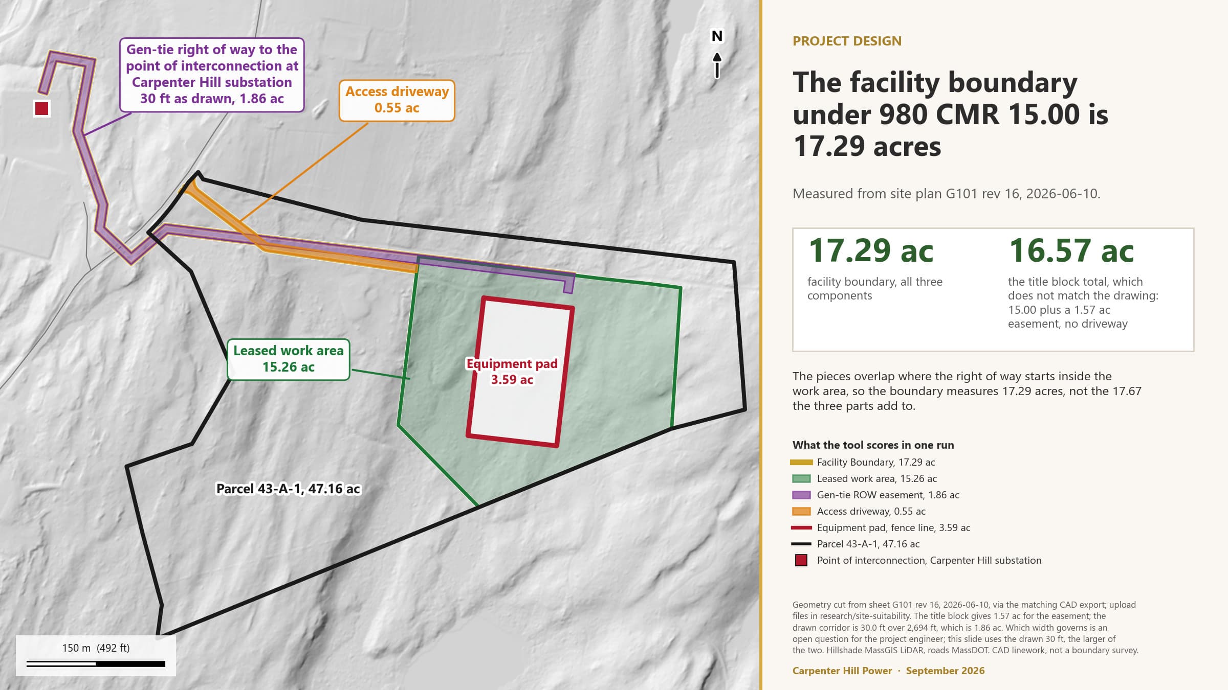
Figure 1. The 17.29-acre Facility Boundary the SGA is measured from.
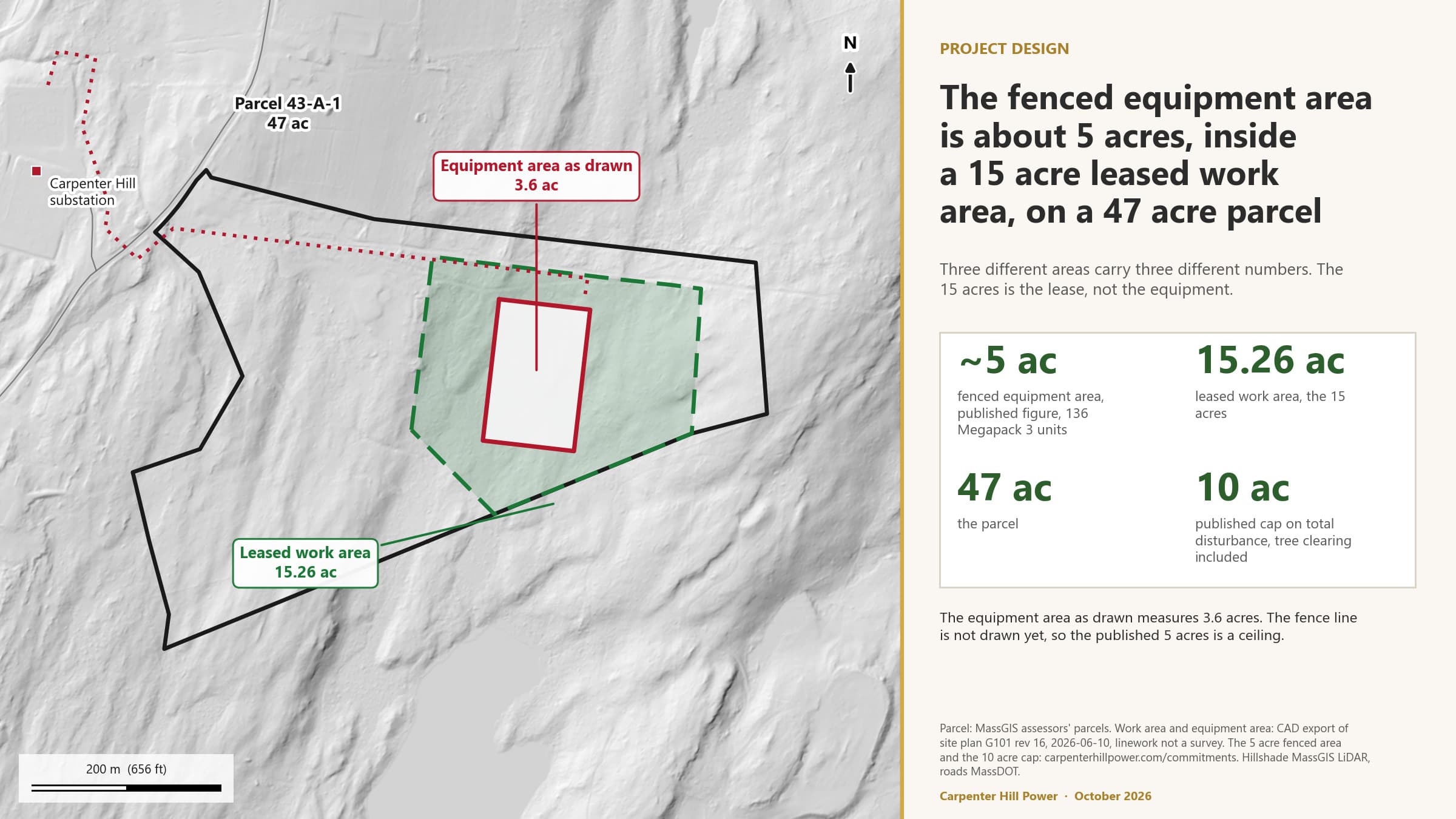
Figure 2. What the Facility Boundary contains: a fenced equipment area of about 5 acres or less, inside the 15.26-acre leased work area, on the 47-acre parcel.
Table 3. Facility types and the radial distance from the Facility Boundary that sets the SGA (980 CMR 15.05(1)(b)).
| Facility type | Applies here? | Radial distance |
|---|---|---|
| Clean Energy Storage Facility (LCESF) | Yes, the whole project | 1 mile |
| Transmission and distribution line | Not as a separate facility. The gen-tie is a component of the storage facility inside its Facility Boundary; the one-mile distance is applied to it as well, which is the more inclusive reading. The project will confirm this reading with the Division of Public Participation. | (0.25 mile, if it applied) |
| Substation | No. The project connects to an existing substation and builds none. | (0.5 mile, if it applied) |
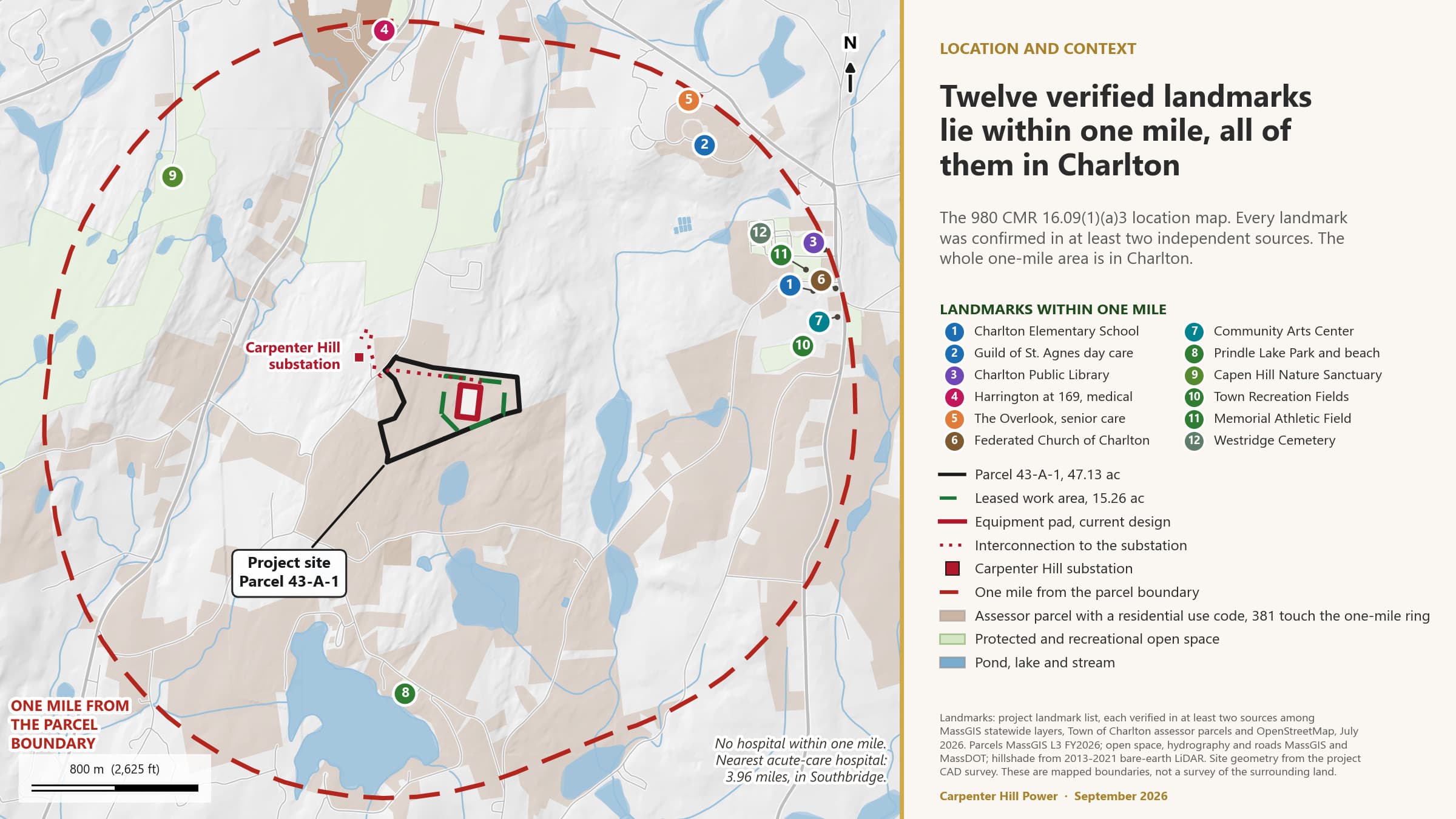
Figure 3. The project location and the landmarks within one mile, all of them in Charlton.
Explanatory comments. The one-mile ring measured from the Facility Boundary encloses about 2,770 acres, and it lies entirely within the Town of Charlton; no other municipality's boundary is inside it. Measured from the parcel boundary instead, the ring encloses about 2,840 acres and adds no block group. The block-group analysis in Section 3 was run both ways and reaches the same result.
CIA Report Template Part II; 980 CMR 15.04 and 15.05(2)
Burdened Areas intersecting the SGA
A Burdened Area is a census block group with a MassEnviroScreen score of 75 or more, or a median household income of 65 percent or less of the state median. Three block groups lie inside the one-mile SGA. One of them qualifies, and it is the one the whole project sits in.
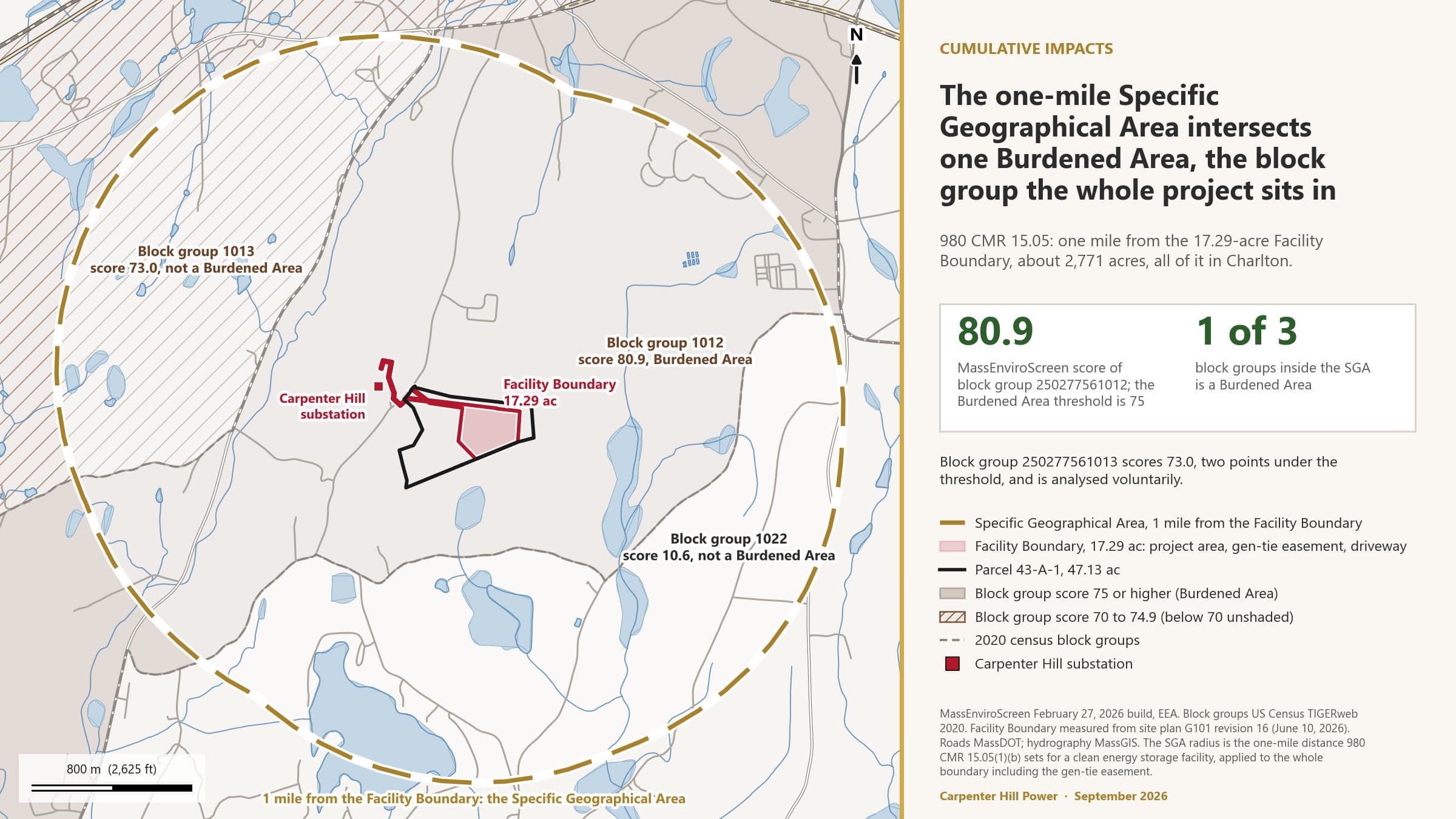
Figure 4. Table 4 attachment. The Facility Boundary, the one-mile SGA, and the block groups it intersects, shaded by MassEnviroScreen score.
Table 5. Census block groups within one mile of the Facility Boundary. MassEnviroScreen February 27, 2026 build.
| Block group | Score | Burdened Area? | Position and how it is treated |
|---|---|---|---|
| 250277561012 (Block Group 2, Tract 7561.01) | 80.9 | Yes, on the score | Contains the parcel, the pad, the driveway and the whole gen-tie easement including its off-parcel length. About 1,450 acres of its 2,525 acres lie inside the SGA. Analysed as 980 CMR 15.06 and 15.07 require. |
| 250277561013 (Block Group 3, Tract 7561.01) | 73.0 | No | Inside the SGA, about 0.34 mile from the Facility Boundary at its nearest point, and about two points under the threshold. Analysed voluntarily in Section 4; Elevated Indicators there carry no legal status under 980 CMR 15.02. |
| 250277561022 | 10.6 | No | Inside the SGA, about 0.30 mile from the Facility Boundary at its nearest point. Not analysed further. |
Explanatory comments. Block group 250277561023, scoring 19.7, lies about 1.04 miles from the Facility Boundary and does not intersect the SGA. The host block group is the only Burdened Area in Charlton. It qualifies under 980 CMR 15.04(1)(a) on its score; its median household income of about 82 percent of the state median does not trip the 65 percent test in 15.04(1)(b). It is not an environmental justice population under the state's separate definition, and this analysis is not an environmental justice screening: 980 CMR 15.00 uses MassEnviroScreen and the Burdened Area test, and nothing else. Because about 1,142 feet of the gen-tie easement runs outside parcel 43-A-1, the check was run on every parcel that hosts a project component; every one falls in the same block group. Under 980 CMR 15.04(5) the analysis relies on the indicator data current when the pre-filing period began on April 9, 2026, which the project understands to be the February 27, 2026 build and will confirm with the Division of Public Participation. Because the SGA intersects a Burdened Area, the analysis continues under 15.05(3) rather than concluding.
CIA Report Template Part III; 980 CMR 15.06
Elevated Indicators
MassEnviroScreen scores every block group on 30 indicators, each as a percentile against every other block group in the state. For a clean energy facility, an indicator above the 50th percentile is an Elevated Indicator, and the project has to assess its effect on each one. The host block group has 16.
Table 6. Statewide percentile values for each indicator. Elevated Indicators, above the 50th percentile, are marked. Only the host block group's marks have legal effect under 980 CMR 15.02; the neighbouring block group is shown voluntarily. MassEnviroScreen February 27, 2026 build.
| Indicator | 250277561012Block Group 2, Tract 7561.01 (host, Burdened Area) | 250277561013Block Group 3, Tract 7561.01 (voluntary, not a Burdened Area) |
|---|---|---|
| Environmental exposures | ||
| Fine particulate matter (PM2.5)6.58 micrograms per cubic metre in both block groups | 54.2 (elevated) | 54.2 (elevated) |
| Ozone | 49.9 | 49.9 |
| Nitrogen dioxide (NO2) | 14.7 | 21.2 |
| Diesel particulate matter | 16.6 | 24.4 |
| Drinking water non-complianceThe host block group is mapped to the Southbridge Water Department's unconfirmed service outline, so this indicator scores a public system; the MassDEP well database records private wells throughout the mile around the site | 0.0 | 61.6 (elevated) |
| Air toxics cancer risk | 21.2 | 19.8 |
| Air toxics respiratory hazard index | 16.7 | 16.7 |
| Proximity to heavy traffic | 13.0 | 21.0 |
| Environmental effects | ||
| Pollution cleanup sites | 90.8 (elevated) | 98.4 (elevated) |
| Groundwater threats | 88.4 (elevated) | 98.9 (elevated) |
| Hazardous waste generators and facilities | 81.4 (elevated) | 89.4 (elevated) |
| Solid waste sites and facilities | 85.6 (elevated) | 0.0 |
| Impaired water bodiesFour pollutant listings in the host block group, five in the neighbour | 83.7 (elevated) | 89.3 (elevated) |
| Climate risks | ||
| Drought | 40.4 | 40.4 |
| Wildfire risk | 77.6 (elevated) | 53.5 (elevated) |
| Flood risk0.4 percent of the host block group's buildings are in a flood zone | 54.3 (elevated) | 64.2 (elevated) |
| Extreme heat days | 18.3 | 18.2 |
| Sensitive populations | ||
| Pediatric asthma | 57.0 (elevated) | 25.6 |
| Low birth weight infantsThe state publishes no value for either block group | No value | No value |
| Elevated blood lead in children | 0.0 | 0.0 |
| Premature mortality | 74.0 (elevated) | 74.0 (elevated) |
| Adult high blood pressure | 80.4 (elevated) | 80.4 (elevated) |
| Coronary heart disease | 73.0 (elevated) | 73.0 (elevated) |
| Chronic obstructive pulmonary disease (COPD) | 62.8 (elevated) | 62.8 (elevated) |
| Adult cancer | 83.3 (elevated) | 83.3 (elevated) |
| Socioeconomic factors | ||
| Adults without a high school diploma | 69.7 (elevated) | 63.3 (elevated) |
| Housing-burdened low-income households | 37.6 | 37.6 |
| Linguistic isolation | 47.2 | 0.0 |
| Poverty | 64.4 (elevated) | 54.6 (elevated) |
| Unemployment | 43.1 | 56.0 (elevated) |
| Elevated Indicators (above the 50th percentile) | 16 of 29 scored | 16 of 29 scoredno legal status: not a Burdened Area |
Highlighted cells are above the 50th percentile. Percentiles compare a block group with every other block group in Massachusetts; they do not say whether any regulatory threshold is exceeded.
Median household income, the indicator the template lists that the state publishes as a share of the state median rather than a percentile.
| Block group | Median household income | Share of the state median | Burdened Area income test (65 percent or less) |
|---|---|---|---|
| 250277561012 | $85,703 | 82.4 percent | Not met |
| 250277561013 | $111,525 | 107.3 percent | Not met |
What drives the score
The host block group's score of 80.9 is the statewide percentile of the product of two group scores, pollution and climate burden at 45.0 and population characteristics at 57.0. Inside the first, the environmental effects component at 86.0 ranks 99.7th of the 5,109 Massachusetts block groups, while the pollution exposure component at 23.3 ranks about 15th. Moving the effects component alone to the statewide median would drop the score from 80.9 to about 40. The effects component is where the burden is: cleanup sites at the 90.8th percentile, groundwater threats 88.4, solid waste sites 85.6, impaired water bodies 83.7, hazardous waste generators 81.4. The second driver is chronic disease prevalence in the sensitive populations component: adult cancer at the 83.3rd percentile, high blood pressure 80.4, premature mortality 74.0, coronary heart disease 73.0, COPD 62.8. These health figures come from CDC PLACES model estimates and MassDEP rates, and they are identical for the two block groups because the estimates are made at a coarser geography.
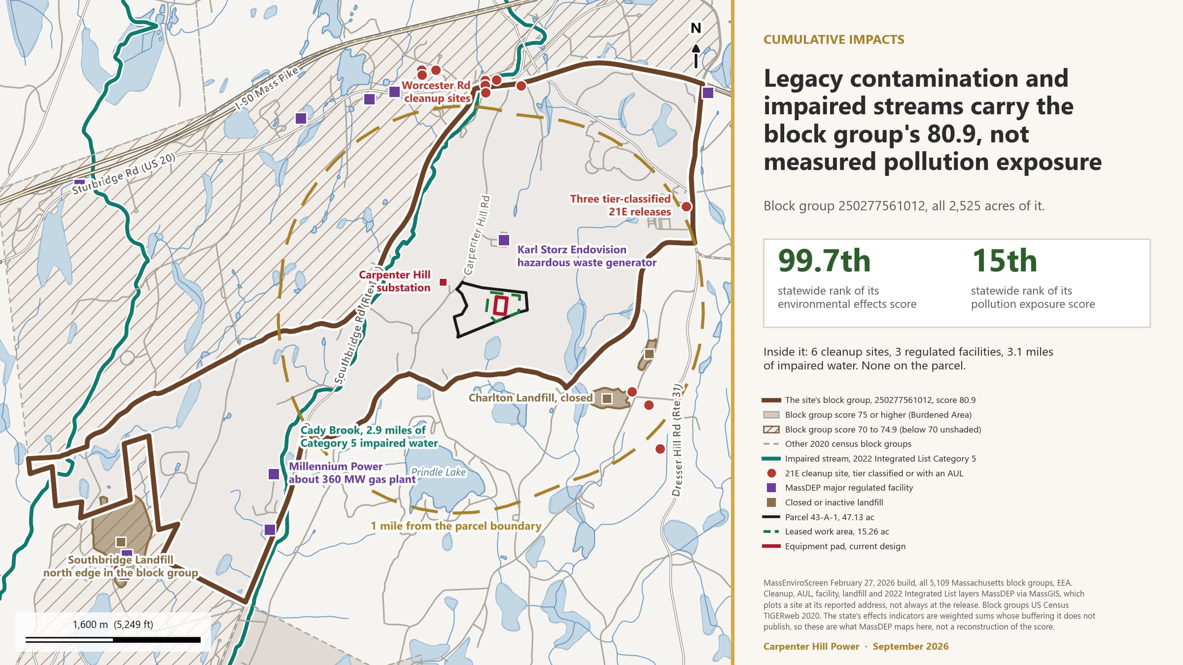
Figure 5. The host block group and the MassDEP features that sit behind its environmental effects score.
Explanatory comments. The state's technical documentation says a high percentile does not by itself mean a regulatory threshold is exceeded or that a health risk exists; the percentiles compare one block group with the others. Three of the four health indicators and the two air quality indicators nearest the threshold, PM2.5 at 54.2 and ozone at 49.9, are regional values shared across central Massachusetts rather than anything local to Carpenter Hill Road. The low birth weight indicator returns no value for either block group, so 29 of the 30 indicators are scored. The neighbouring block group, analysed voluntarily, also carries 16 indicators above the 50th percentile, with a different set: it adds drinking water non-compliance and unemployment and drops solid waste sites and pediatric asthma. Elevated Indicators there have no legal status under 980 CMR 15.02, because the definition applies only where the SGA intersects a Burdened Area, but the project impacts assessed in Sections 5 and 6 reach it in the same ways and the same conclusions apply.
CIA Report Template Part IV.A; 980 CMR 15.07
Construction phase: project impacts on the Elevated Indicators
For each Elevated Indicator, the question is whether construction of the project would materially exacerbate the condition it measures: worsen it, leave it alone, or improve it. The test in the template's Appendix B looks at standards, perceptibility, measurability, duration, geographic extent, resilience, social and health effects, and the potential for contamination to migrate. Construction runs 12 to 18 months.
The determinations below take account of the measures the project has made a firm commitment to undertake, as 980 CMR 15.07 allows. Those are the commitments on the public Commitment Tracker and the permit requirements the project cannot avoid; the tracker links each to what closes it. Where a determination depends on a study that is not finished, the row says so.
Table 7. Construction phase project impacts related to the Elevated Indicators in block group 250277561012. Percentiles in parentheses.
| Elevated Indicator | Project impact during construction | Disproportionate Adverse Effect? | Rationale or reference |
|---|---|---|---|
| Fine particulate matter (PM2.5) (54.2) | Burden, minor and temporary: dust from clearing, grading and gravel placement, and diesel exhaust from equipment and deliveries over 12 to 18 months. | No (preliminary) | The indicator is a regional annual average at the 54th percentile, shared across the region. Construction dust and exhaust are local, intermittent and short-lived; dust control on the pad and the driveway, a stabilized construction entrance and idling limits are standard conditions of the construction stormwater permit and the Board's common conditions. No exceedance of the national PM2.5 standard is expected, and a casual observer beyond the parcel line would not notice a change in ambient PM2.5. |
| Pollution cleanup sites (90.8) | No impact or insignificant. Construction creates no new cleanup site unless a reportable release occurs. | No (preliminary) | Fuel and lubricants on site during construction are handled under a Spill Prevention, Control and Countermeasure plan and a Licensed Site Professional engaged before construction, both expected as permit conditions. A release above the reportable quantity would be reported and cleaned under Chapter 21E. The indicator counts sites requiring oversight; the project adds none. |
| Groundwater threats (88.4) | Burden, potential and controlled: temporary dewatering in poorly drained Ridgebury soil, fuel storage, and concrete work on a site in thin till over bedrock. | No (preliminary), conditional on the geotechnical results | The pad sits 76 percent on poorly drained soil with a seasonal water table within inches of the surface, so dewatering and recharge design follow the borings, which are done after the pre-filing engagement period, before the Application. No injection, no on-site wastewater discharge, no groundwater discharge permit. Erosion controls and the SPCC plan bound the spill pathway. The surface flow-routing screen places two domestic wells downgradient in the pad's own drainage, 0.39 and 0.45 mile away on T Hall Road, drilled about 260 and 605 feet deep into bedrock that starts 14 and 20 feet down; the screen follows land surface and does not say any well is or is not affected. A door-to-door well survey within half a mile, not yet started, locates the 16 records that cannot be placed. |
| Hazardous waste generators and facilities (81.4) | No impact or insignificant. Construction generates universal waste and small quantities of used oil, handled by licensed haulers. | No (preliminary) | The indicator is a weighted count of registered generators and facilities. A construction site is not a registered facility, and construction waste goes off site under the contractor's registration. No treatment, storage or disposal facility is created. |
| Solid waste sites and facilities (85.6) | No impact or insignificant. Cleared timber, stumps and construction debris go to permitted facilities off site. | No (preliminary) | The indicator counts solid waste sites and facilities in and around the block group. The project creates none and disposes of nothing on site; stump and debris burial is not proposed. |
| Impaired water bodies (83.7) | Burden, potential and controlled: sediment from about 10 acres of disturbance could reach the unnamed stream south of the pad. | No (preliminary) | Runoff from the pad drains south to a shrub swamp about 300 feet away and on down an unnamed stream about 2 miles to McIntyre Pond, a Category 3 water. Cady Brook, the Category 5 stream that carries the block group's impairment listings, is in a different drainage. Silt fence, soil re-establishment and cover cropping run through construction under the construction stormwater permit, a published commitment. The 45.6 acres of clean run-on from above the pad are diverted around the work. No pollutant is added to any listed water body. |
| Wildfire risk (77.6) | Burden, minor and temporary: hot work, fuelled equipment and cleared slash in a wooded area at the 77.6th percentile for wildfire hazard potential. | No (preliminary) | No batteries are energized until commissioning. Hot work permits, spark arrestors, fire extinguishers on equipment and slash removal are standard construction fire prevention measures under the state fire code and the Charlton Fire Department's authority. Construction does not change the wildfire hazard potential the indicator measures, which is a property of fuels and terrain across the block group. |
| Flood risk (54.3) | No impact or insignificant. The whole site is in FEMA Zone X, minimal flood hazard; nothing is built in a flood zone. | No (preliminary) | The indicator is the share of the block group in a one percent annual chance flood zone. The nearest special flood hazard area is about 0.2 mile away. Temporary basins and diversions during construction hold runoff on the parcel; the project adds nothing to any mapped flood zone. |
| Pediatric asthma (57.0) | Burden, minor and temporary, through the same dust and exhaust pathway as PM2.5. | No (preliminary) | The nearest homes are about 500 feet or more from the equipment area, and no school or daycare is on Carpenter Hill Road near the site. Dust and exhaust controls as above. The indicator is a school-enrollment prevalence at the 57th percentile that construction of this duration and scale would not measurably change. |
| Premature mortality (74.0) | No impact or insignificant. | No (preliminary) | The pathways from construction to mortality would be air quality or an accident. Air impacts are minor and temporary as above; construction safety is governed by OSHA and the contractor's safety plan. No measurable change to a block-group mortality rate. |
| Adult high blood pressure (80.4) | No impact or insignificant. Construction noise and traffic are the only plausible pathway, and both are temporary. | No (preliminary) | Truck routing and timing set with the town before work begins, and a traffic management plan filed with the town, are published commitments; construction hours are set in the permit conditions. Noise from construction is regulated under the MassDEP noise policy and the Board's common conditions. |
| Coronary heart disease (73.0) | No impact or insignificant. | No (preliminary) | As for high blood pressure. No air emissions source is added; construction exhaust is temporary and local. |
| Chronic obstructive pulmonary disease (COPD) (62.8) | Burden, minor and temporary, through dust and diesel exhaust. | No (preliminary) | As for PM2.5. Controls under the construction stormwater permit and idling limits; no exceedance of an air standard is expected. |
| Adult cancer (83.3) | No impact or insignificant. | No (preliminary) | No air toxics source is added. The block group's air toxics cancer risk indicator sits at the 21st percentile and is not elevated. Construction does not introduce a carcinogen pathway. |
| Adults without a high school diploma (69.7) | Benefit, possible: construction employment and trades training over 12 to 18 months. | No | A local hiring preference and a training partnership are proposals in the draft Community Benefits Plan, not yet commitments. The project met the MassHire Central Region Workforce Board on August 14, 2026 and Bay Path Regional Vocational Technical High School on September 8, 2026. Construction employment does not worsen the indicator and may help the people it measures. |
| Poverty (64.4) | Benefit, possible: construction wages and local spending during the build. | No | As above. No pathway by which construction increases the share of households at or below twice the poverty level. |
Explanatory comments. Two Elevated Indicators would have carried a different answer without firm commitments: impaired water bodies, because sediment from 10 acres of disturbance above a wetland chain is the kind of impact the indicator measures, and groundwater threats, because of the soil the pad sits on. In both cases the commitment that bounds the impact is required by a permit the project cannot avoid, which is the strongest kind of commitment for the purposes of 980 CMR 15.07. The MEPA Office and MassDEP raised the wetland delineation, stormwater and run-on at the September 4, 2026 consultation, and the rows above are consistent with what the project told them.
CIA Report Template Part IV.B; 980 CMR 15.07; 2024 Climate Act clause (ii)
Operations phase: project impacts on the Elevated Indicators
In operation the facility charges and discharges batteries, burns nothing, has no stack, uses no process water and discharges no wastewater. The impacts that remain are the ones that come from the equipment itself: a credible fire event, the liquids on site, cooling fan and inverter noise, new impervious surface, and cleared forest. This section assesses each against the 16 Elevated Indicators, then asks the Climate Act's separate question about the effects of climate change.
Table 8. Operations phase project impacts related to the Elevated Indicators in block group 250277561012.
| Elevated Indicator | Project impact during operations | Disproportionate Adverse Effect? | Rationale or reference |
|---|---|---|---|
| Fine particulate matter (PM2.5) (54.2) | No impact or insignificant. No combustion and no stack; a handful of maintenance vehicle trips a week. | No (preliminary) | The only air emissions in normal operation are from occasional maintenance vehicles. A fire event is assessed under wildfire risk below. |
| Pollution cleanup sites (90.8) | No impact or insignificant in normal operation. A release from a transformer or a fire event is the pathway. | No (preliminary), conditional on the fire protection engineering report | The main power transformer and the medium-voltage transformers hold the largest liquid inventory on site, in secondary containment sized to 110 percent under the Board's draft common conditions, with an SPCC plan. Firefighting water is captured on site under a published commitment, in the current design by a continuous concrete foundation and a lined drainage swale, so a fire does not become a release to soil. Battery chemistry is lithium iron phosphate, with no nickel, cobalt or manganese. A reportable release would be handled under Chapter 21E; the design's purpose is that none occurs. |
| Groundwater threats (88.4) | Burden, potential and controlled: liquids stored on site, new impervious surface over a shallow water table, and firefighting water in a fire event. | No (preliminary), conditional on containment design and the fire protection engineering report | Secondary containment, SPCC, firewater capture with testing before disposal, no on-site wastewater, and no groundwater discharge. Post-construction runoff held at today's rate under state stormwater standards with recharge designed to the borings. A groundwater monitoring program with the Board of Health is a published commitment, and neighbour well baseline testing is a proposal in the draft Community Benefits Plan. This report does not state that any well is or is not affected; the flow-routing screen is a screen, and the two downgradient wells draw from fractured bedrock the screen does not model. |
| Hazardous waste generators and facilities (81.4) | Burden, minor: the facility may register as a very small quantity generator for used oil, universal waste and any cells replaced over its life. | No (preliminary) | The indicator is a weighted count. The project will report its generator status in the Application. It is not a treatment, storage or disposal facility; spent modules are returned to the manufacturer's recycling stream, not stored on site. |
| Solid waste sites and facilities (85.6) | No impact or insignificant. | No (preliminary) | No solid waste is disposed of on site during operation or at decommissioning, when equipment is removed and battery materials go to recycling under the plan filed under 980 CMR 1.10. |
| Impaired water bodies (83.7) | No impact or insignificant, controlled: about 5 acres of new impervious surface draining to a wetland chain in a different drainage from Cady Brook. | No (preliminary) | Stormwater managed to the Massachusetts Stormwater Standards, no net increase in runoff, run-on diverted, a catchment swale along the southern boundary in the current design, and the stormwater design sized to the 2070 100-year storm or the departure documented, as the MEPA Office asked. No pollutant is added to any listed water body. |
| Wildfire risk (77.6) | Burden, potential: thermal runaway in a battery module is the credible event for lithium-ion storage, on a forested site at the 77.6th percentile for wildfire hazard potential. | Not yet determined. Preliminary: no, conditional on the fire protection engineering report and the hazard mitigation analysis filed with the Application | This is the indicator most closely coupled to the technology and the one on which the determination waits. The units are to be evaluated under the UL 9540A test method; the manufacturer states the Megapack 3 is designed to meet and exceed it, no report for it is published yet, and the unit-specific test report comes with the Application. In the current design: NFPA 855 separation, a 26-foot fire lane around the equipment, 50 feet from equipment to fence, and cleared ground between the equipment and the treeline; final engineering sets the details. An Emergency Action Plan built with the Charlton Fire Department and independently reviewed at the project's expense is a published commitment. MassDEP asked on September 4 whether the fire lane gives apparatus enough access to keep a fire from spreading into the surrounding woods; that question is answered in the fire protection engineering report. A smoke and gas plume dispersion analysis is a published commitment and has not started. The Emergency Action Plan and the plume analysis are posted when done. |
| Flood risk (54.3) | No impact or insignificant. | No (preliminary) | The site is in Zone X. About 5 acres of new impervious surface is managed under the stormwater standards with no net increase in peak runoff, so the project adds no flood exposure downstream. The extreme precipitation projection, 10.7 inches in 24 hours by 2070, is an input to the design. |
| Pediatric asthma (57.0) | No impact or insignificant. | No (preliminary) | No operating air emissions. A fire event is assessed under wildfire risk. |
| Premature mortality (74.0) | No impact or insignificant. | No (preliminary) | No operating air emissions and no discharge. The fire event pathway is assessed under wildfire risk. |
| Adult high blood pressure (80.4) | Burden, potential: continuous cooling fan and inverter noise at the nearest property lines and homes. | No (preliminary), conditional on the sound study | Noise is the one operating impact that reaches homes. The MassDEP noise policy limits project sound to 10 decibels above background at the property line and the nearest residence, with no pure tone, and the Board applies it as a condition. The design is required to meet it, and the sound study against the policy, a published commitment, is what shows whether the current layout does. The nearest home is the landowner's, about 500 feet from the equipment area. A screening-level sound model was built in September 2026. It is preliminary: the Megapack 3 has no published sound data yet, so the model uses the earlier unit as a stand-in, and an acoustics consultant has not reviewed it. It indicates the current layout does not meet the policy at the nearest property lines without changes, so the layout is expected to change. The screening results are posted in the Slide Library, marked preliminary and not confirmed by a sound engineer, and summarised below. Any layout change it produces is logged on the Commitment Tracker with the reason. |
| Coronary heart disease (73.0) | No impact or insignificant. | No (preliminary), conditional on the sound study | As for high blood pressure. No air emissions. |
| Chronic obstructive pulmonary disease (COPD) (62.8) | No impact or insignificant. | No (preliminary) | No operating air emissions. |
| Adult cancer (83.3) | No impact or insignificant. | No (preliminary) | No air toxics source. Magnetic field analysis, not yet started, is filed with the Application under the Board's practice; the site's nearest home is about 500 feet from the equipment. |
| Adults without a high school diploma (69.7) | No impact or insignificant. A small number of operations and maintenance positions. | No | Operations employment is small. Any operations hiring preference is a proposal in the draft Community Benefits Plan. |
| Poverty (64.4) | Benefit, possible: property tax or negotiated payments to the Town of Charlton over the operating life. | No | The form and amount of payments to the town are a decision for the town and the project together and are not stated in this draft. The tax analysis is a published commitment and is in progress. No pathway by which operation increases poverty. |
The fire event: what the US record shows
The wildfire risk row above waits on the fire protection engineering report. What can be set down now is the record of what has happened at grid battery fires in the United States, because residents have asked whether shelter and evacuation orders are the exception or the rule, and because the record is what the Emergency Action Plan is written against. For scale, EPRI's global incident database shows the failure rate falling from about 4 events per gigawatt-hour of installed storage in 2018 to about 0.04 in 2025, a drop of about 99 percent, while installed storage worldwide grew to nearly 700 gigawatt-hours; those totals are floors, because most US fires are reported only voluntarily. Nineteen US grid battery fires since 2019 have a public record of the response. Twelve led to a shelter-in-place or evacuation order, four to road closures only, and three to no order, so an order is the rule once smoke is visible near people. Every order at an outdoor unit or container was lifted within a day, except Escondido's two days and La Verne's three. The orders that ran a week or more were at batteries inside a building. At the three outdoor fires in lithium iron phosphate units, the chemistry this project uses, no one was asked to leave home. Where air, soil or water were sampled afterwards, the two outcomes that reached the environment, metal deposition in a marsh and a later lawsuit alleging PFAS chemicals in public wells from the firefighting runoff, were both at batteries inside buildings. At the outdoor fires with published sampling, hydrogen fluoride was not detected at the perimeter, hydrogen cyanide was measured close to the units at three fires, in every case below the occupational exposure ceiling, and the wells tested afterwards were clean. This is the record, not a prediction for this site. It is sorted by what is comparable: outdoor lithium iron phosphate units first, outdoor units of other chemistry next, batteries inside buildings last.
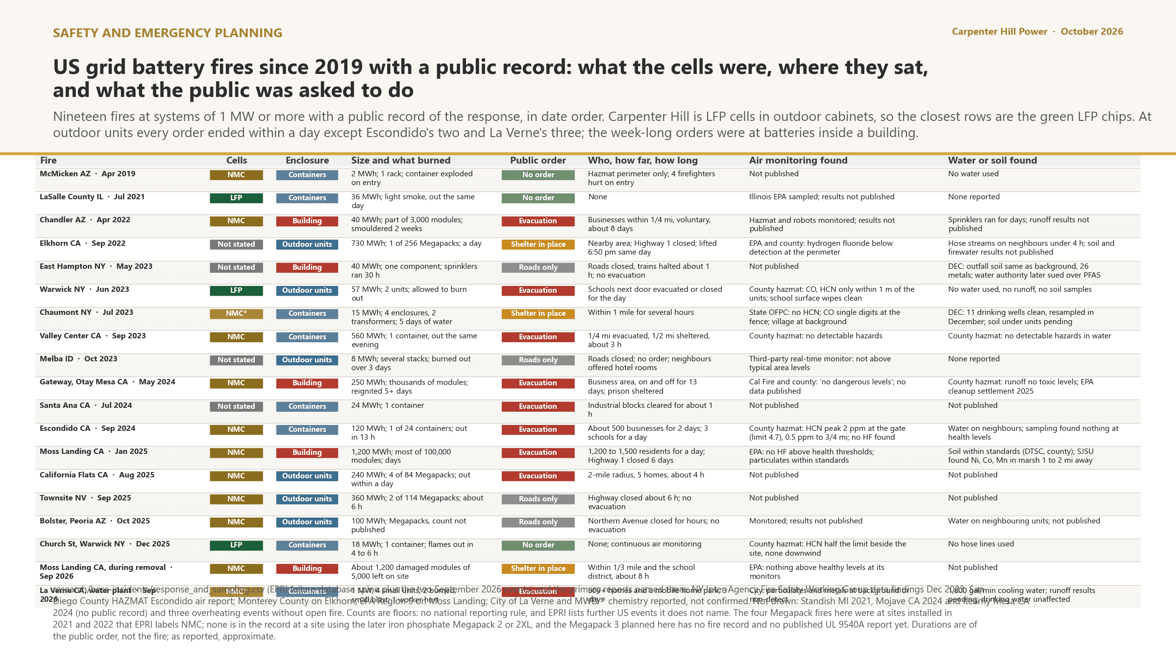
Figure 6. Every US grid battery fire since 2019 with a public record: chemistry, enclosure, the public order, and what sampling found.
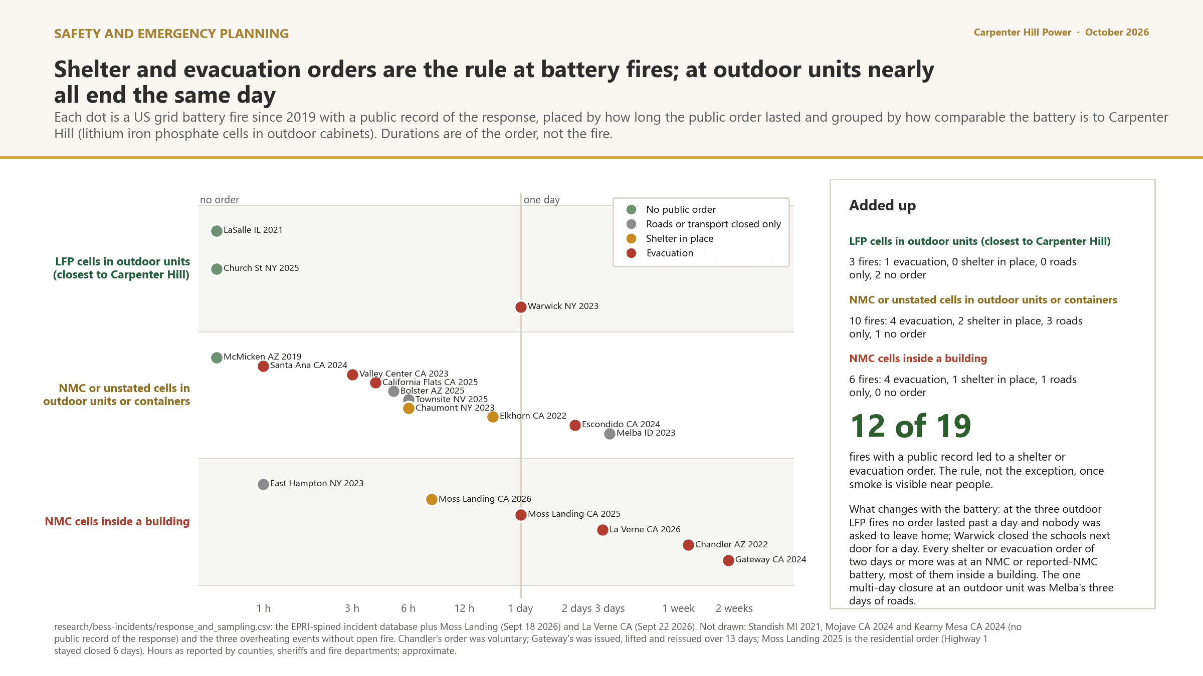
Figure 7. How often orders were given and how long they lasted, by battery type. Every order at an outdoor unit was lifted within a day, except one that ran about two days; the orders that lasted several days were at an NMC or reported-NMC battery, most of them inside a building.
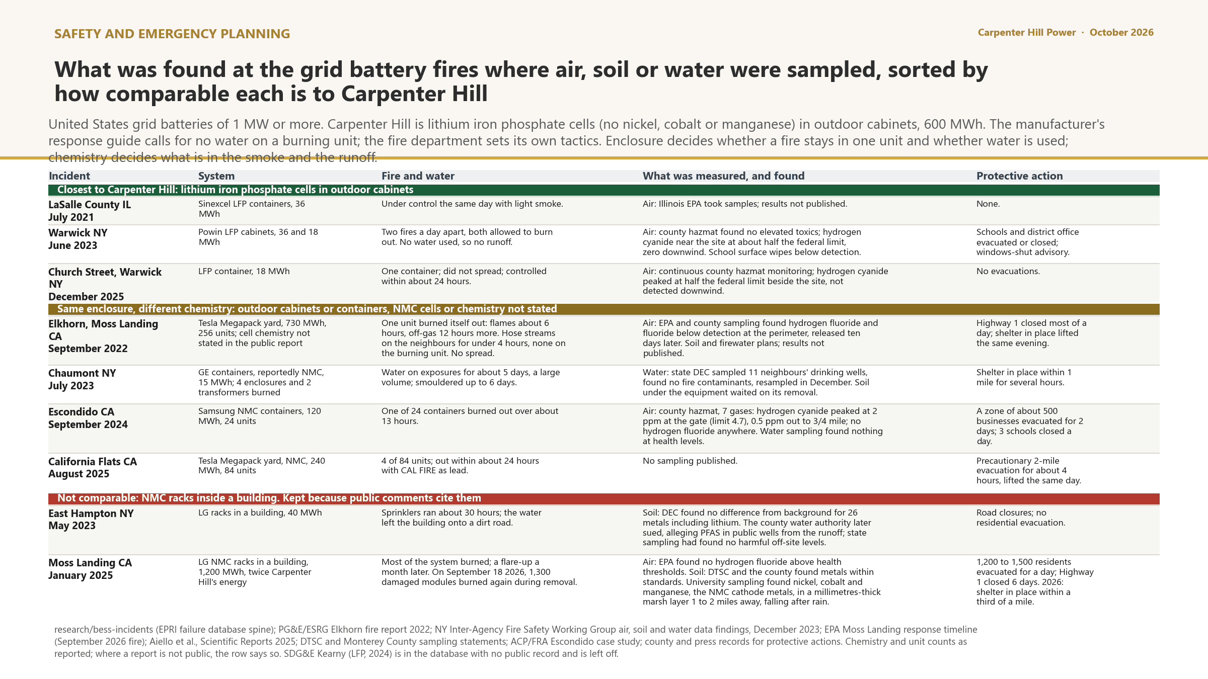
Figure 8. What reached the environment at the fires where it was measured, sorted by how comparable each fire is to this site.
Where anything leaving the pad would go
Two questions from public comment are about reach: whether smoke from a fire would settle on the homes along Gillespie Road, which the comment describes as a valley, and how far anything carried in runoff or firefighting water would travel. Terrain answers the first in part. Gillespie Road lies about a mile north of the pad, and an 820-foot ridge stands between them: the pad sits at about 719 feet, the road between about 707 and 762 feet, and no downhill route from the pad reaches the road. Ten years of wind records at Worcester Regional Airport show the wind from the west about 40 percent of the time and from the site toward Gillespie Road about 10 percent of hours. This is terrain and wind climatology, not a plume model. The site-specific gas plume analysis is a published commitment, filed with the Application and posted here, and has not started. This report commits to the analysis, not to its result.
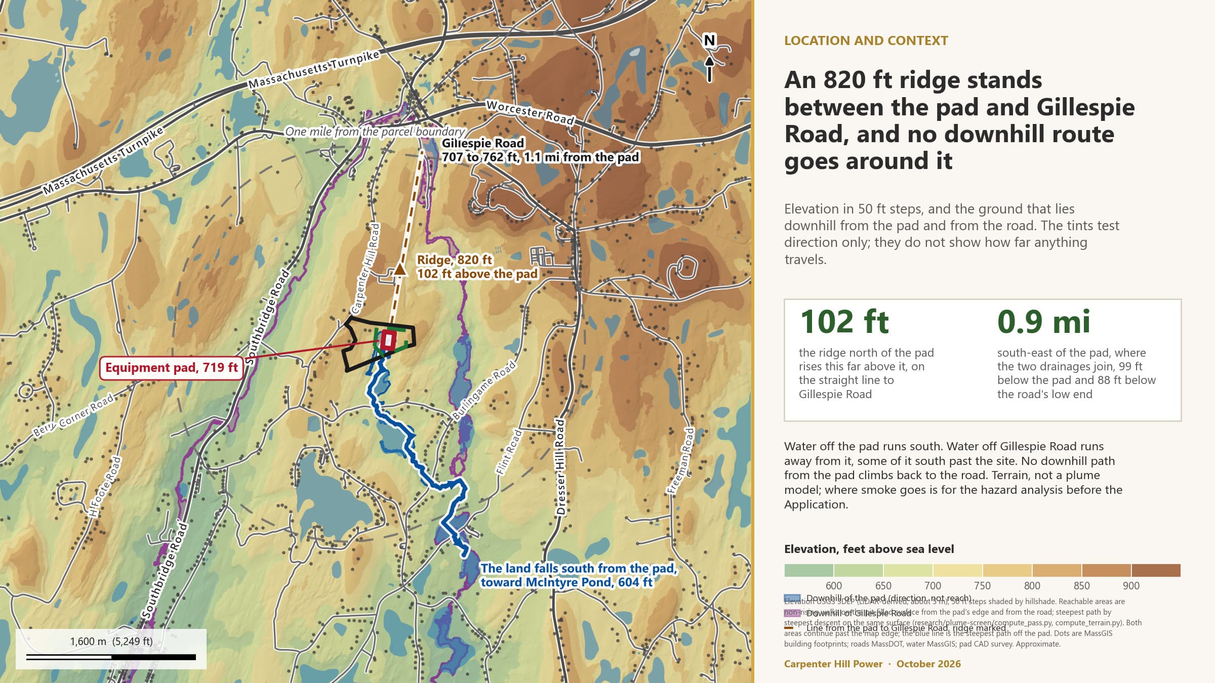
Figure 9. Where the pad drains, where Gillespie Road drains, and the ridge between them. Direction, not reach.
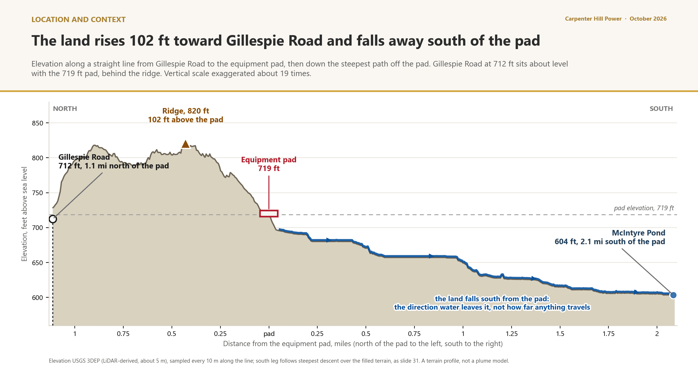
Figure 10. Elevation along a line from Gillespie Road through the pad to McIntyre Pond.
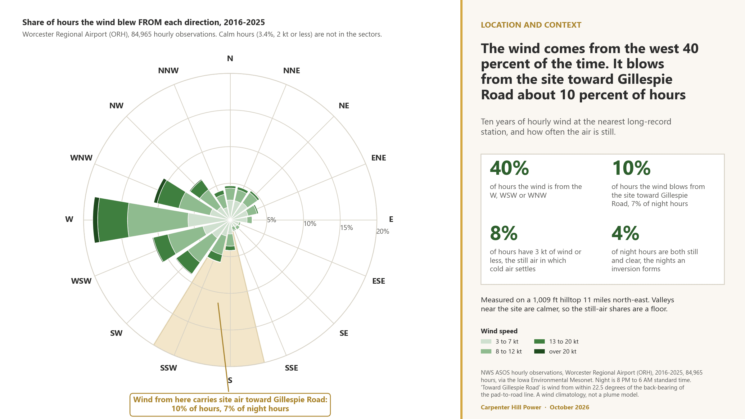
Figure 11. Ten years of wind at Worcester Regional Airport. Where the wind comes from, and how often the air is still.
For the second question, the land south of the pad does two things to anything that leaves it: it dilutes it by area and it holds it in wetlands. The pad is about 7.5 percent of the land draining through its own outlet, 2 percent of the land draining past T Hall Road half a mile away, about 1 percent at Burlingame Road, and 0.2 percent of the 1,651 acres that drain through McIntyre Pond. Fifteen mapped wetlands, 63 acres in all, lie on the path before the pond, and more than half of its length runs through mapped wetland. Those shares describe area, not concentration, timing or containment. That is why firewater capture and the stormwater design are commitments whatever the shares say, and why a baseline of soil and water conditions before construction is proposed for the scope of the Emergency Action Plan and the monitoring program.
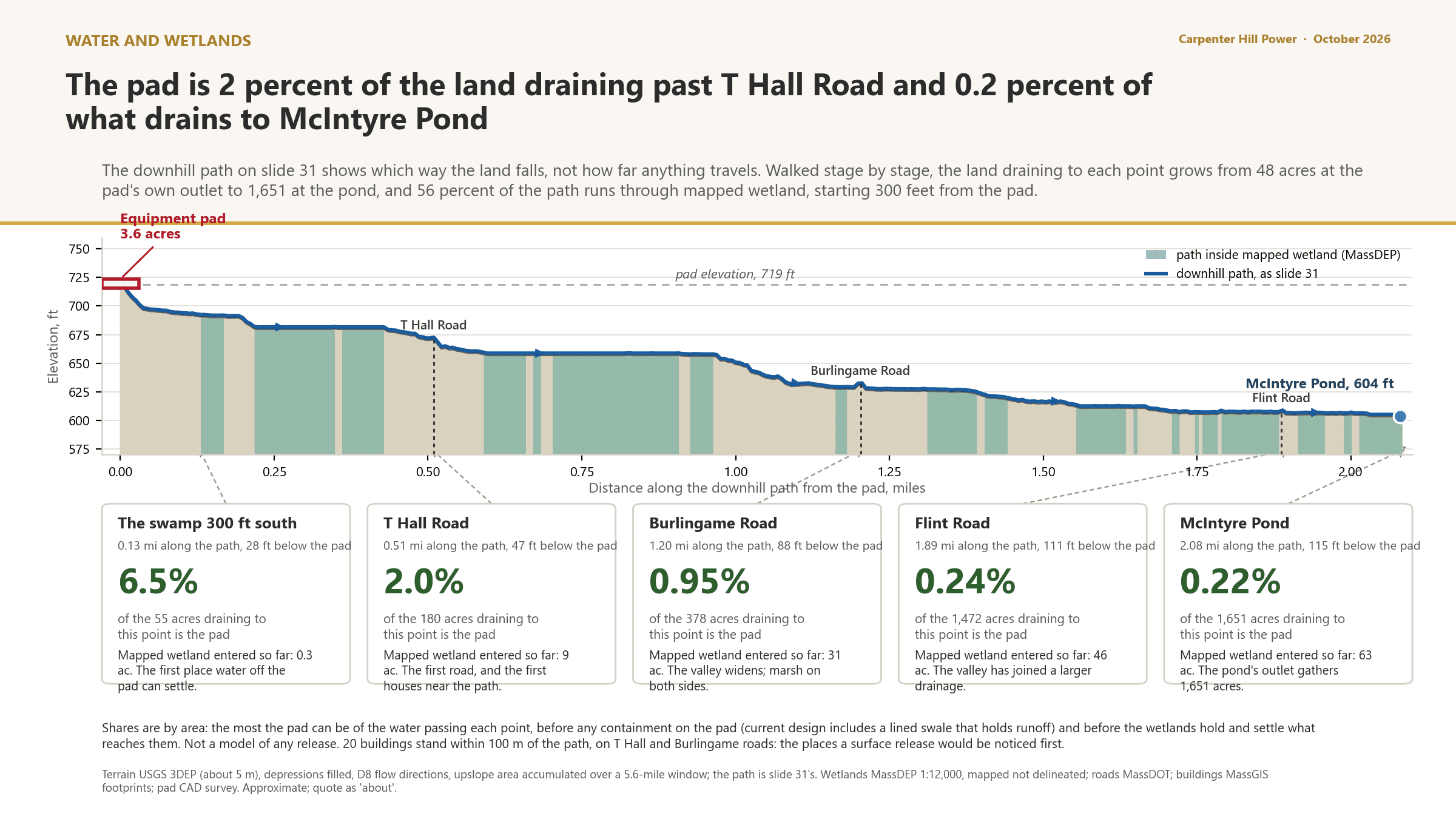
Figure 12. What the land does to anything that leaves the pad, stage by stage: the pad's share of the drainage at each point, and the wetlands on the path.
Sound: a preliminary screening model, not yet confirmed by a sound engineer
The adult high blood pressure row rests on the sound study. What exists today is a screening-level model built in September 2026 by the project team. It is preliminary and has not been reviewed or confirmed by a sound engineer; its figures are posted in the Slide Library marked that way and are reproduced here so the row can be checked, not as a result. The model stands in the manufacturer's published data for the earlier Megapack unit for the Megapack 3, which has none yet; spreads 136 units over the 40 rows on the current drawing; uses the standard outdoor propagation method with terrain screening; and has no measured background, so it cannot say whether the policy is met, only what background would be needed. On that basis the night typical case puts about 59 dBA at the closest property line, 54 at the landowner's house and 48 at the nearest neighbour. The mitigation package the model tested, a night fan cap, low-noise transformers and a 20-foot wall, brings those to about 51, 47 and 43. The model's own reading is that the two closest property lines do not meet the policy with the rows where they are, so the layout is expected to change, and that the professional study should test setting the pad lower into the slope and berms on the north and southwest sides. Trees are given no credit, because the state requires the leaf-off case. Every number here is a screening figure with a stand-in source and no measured background, from a model no sound engineer has confirmed. The professional study against the MassDEP noise policy, with the Megapack 3 data, replaces it, and the final levels are whatever that study finds.
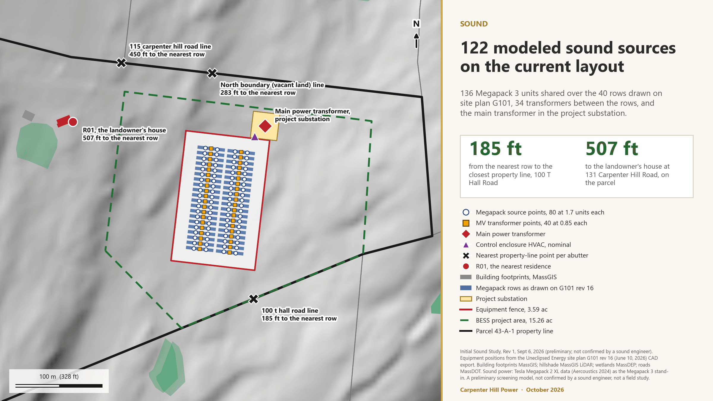
Figure 13. The modeled sound sources on the current layout, with a stand-in for the Megapack 3, which has no published sound data. Preliminary; not confirmed by a sound engineer.
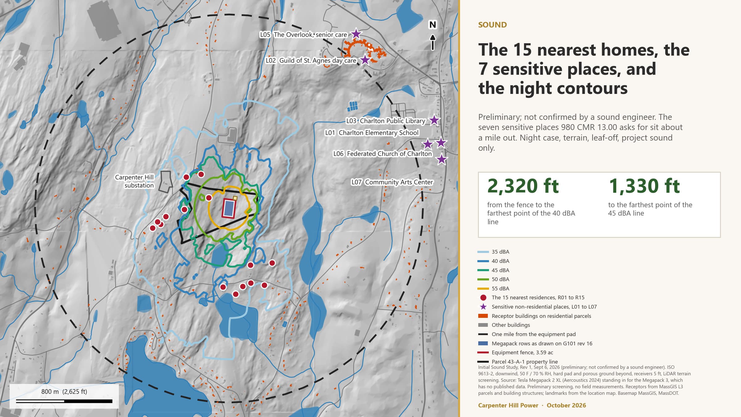
Figure 14. Homes and sensitive places within a mile, and how far the night-time contours reach. Preliminary; not confirmed by a sound engineer.
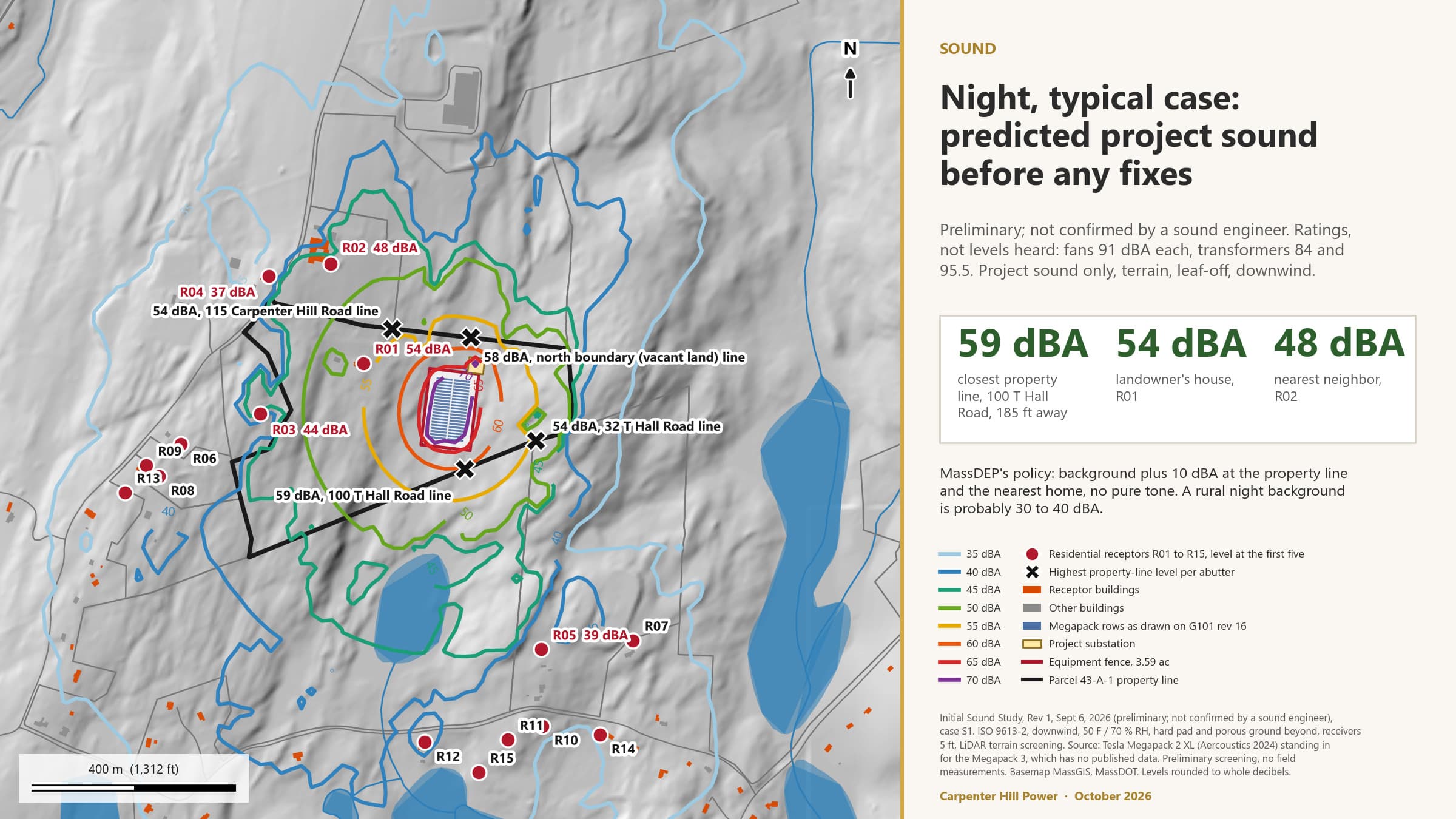
Figure 15. Night typical case before any mitigation. Preliminary screening figures; not confirmed by a sound engineer.
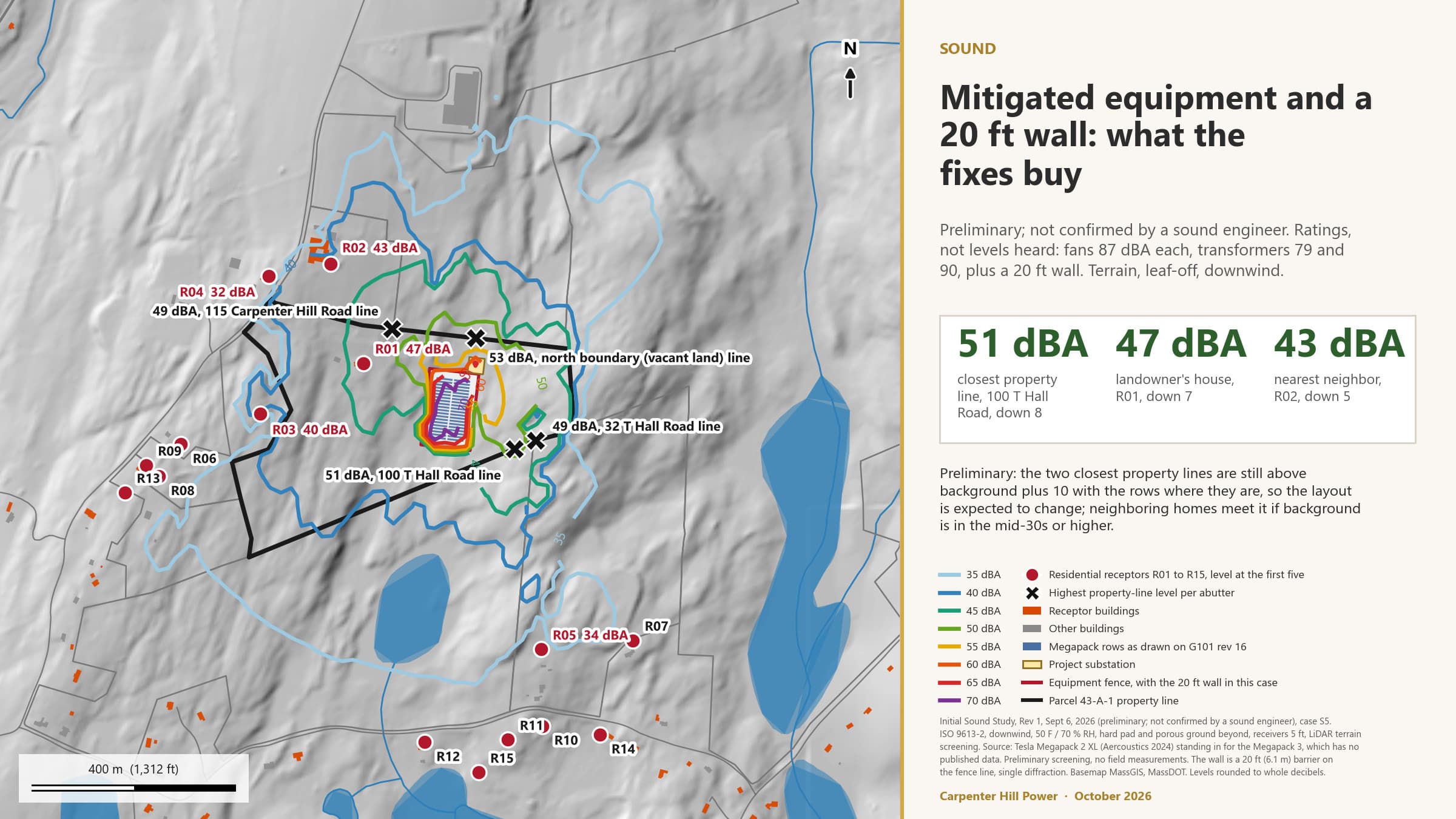
Figure 16. The mitigation package the model tested. A test case, not a design decision. Preliminary; not confirmed by a sound engineer.
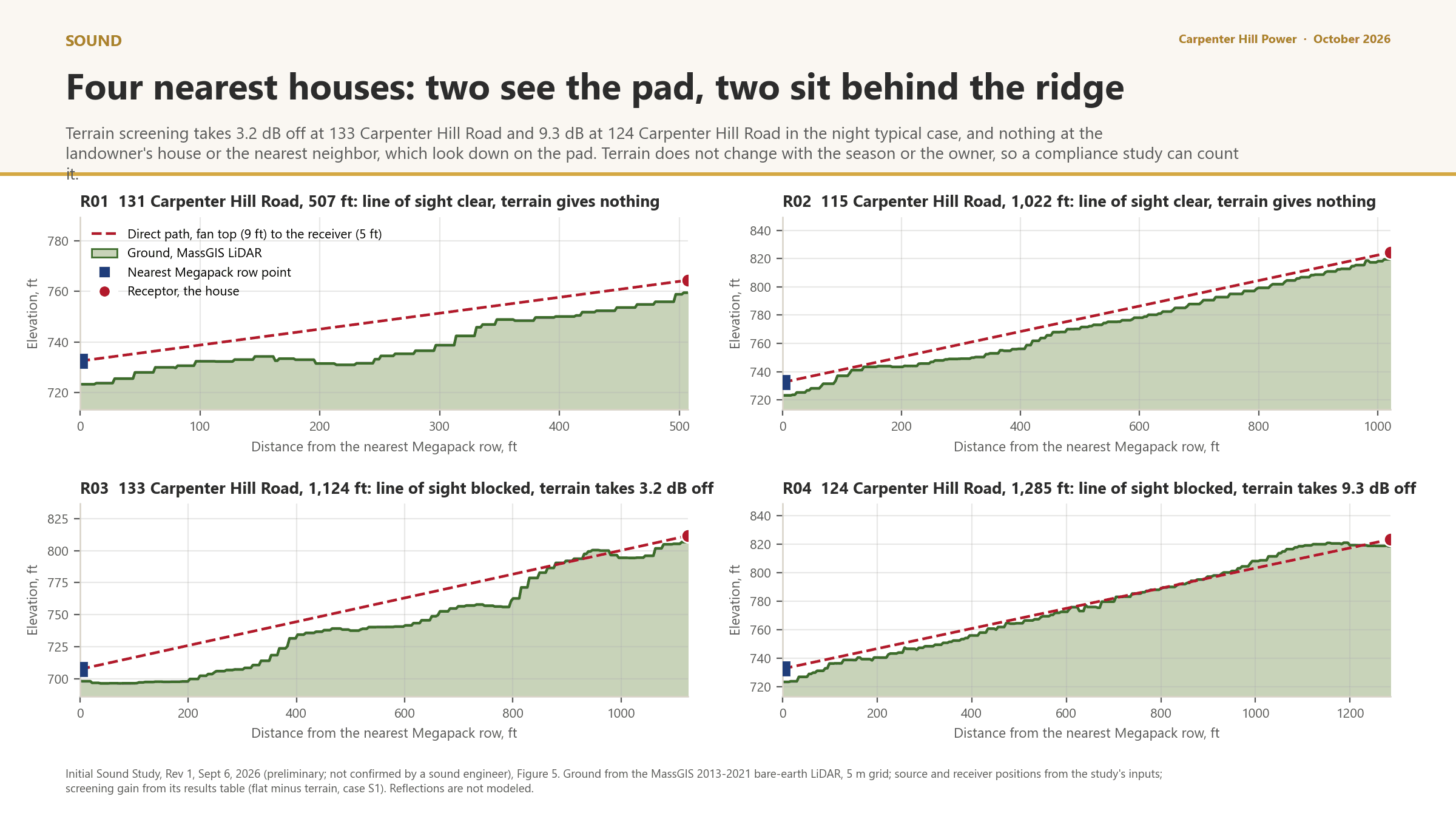
Figure 17. Terrain between the equipment and the four nearest houses. Two see the pad and get no help from the ground. Preliminary; not confirmed by a sound engineer.
The effects of climate change
The Climate Act asks separately whether the project would increase or reduce the effects of climate change on the area. Both directions apply. The facility stores electricity and returns it to the grid when demand is highest, which supports the region's reliability as more of its supply comes from wind and solar and less from fossil generation; that reduction in the effects of climate change is regional, not confined to the block group, and the Board weighs it in the Application. Locally, the project clears up to 10 acres of forest, which is a loss of carbon storage and shade, and adds about 5 acres of gravel and equipment that will run warmer than the woods around it on a hot day. Both local effects are small in extent, and the block group's extreme heat indicator sits at the 18th percentile and is not elevated. The site's own climate exposure, high for extreme precipitation and extreme heat by 2070, is an input to the stormwater design and the equipment thermal specification rather than an impact on the community.
Explanatory comments. Every operating determination above is preliminary because three studies it rests on are not finished: the fire protection engineering report with the hazard mitigation analysis, the sound study against the MassDEP noise policy, and the final stormwater and containment design after the borings. Each is a published commitment with a place on the Commitment Tracker, and each is filed with the Application. If any of them shows that an Elevated Indicator would be materially exacerbated, Section 7 becomes a table of Remedial Actions under 980 CMR 15.08 rather than a list of commitments, and this report is reissued to say so.
CIA Report Template Part V; 980 CMR 15.08
Avoidance, minimization and mitigation
980 CMR 15.08 requires Remedial Actions only where a Disproportionate Adverse Effect is found. None is found in this draft. The measures below are listed anyway, in the mitigation hierarchy the guidance sets out, because they are the reason the answers in Sections 5 and 6 are no, and because the Board can make any of them an enforceable condition.
Table 9. Measures that avoid, minimize or mitigate project impacts on the Elevated Indicators. Every row is a published commitment or a permit requirement the project cannot avoid.
| Elevated Indicators addressed | Type | Measure | How it addresses the impact | Basis and documentation |
|---|---|---|---|---|
| Impaired water bodies; groundwater threats; flood risk | Avoidance | No wetland fill; setbacks from wetland resource areas, mapped today and field delineated after the pre-filing engagement period, before the Application; the whole site in FEMA Zone X. | Keeps the work out of the resource areas the indicators measure. | Site plan G101 revision 16; ANRAD and Notice of Intent to the Charlton Conservation Commission. |
| Wildfire risk; adult cancer; COPD; PM2.5 | Avoidance | No combustion, no stack, lithium iron phosphate chemistry. | Removes the air pathway in normal operation. | Project description; equipment data sheets in the Document Library. |
| Groundwater threats; impaired water bodies | Minimization | Tree clearing outside the transmission right-of-way held at or under 10 acres; the 45.6 acres of run-on diverted around any containment; post-construction runoff held at today's rate; a catchment swale along the southern boundary in the current design. | Limits sediment and runoff from the pad to the wetland chain south of it and keeps clean water out of the containment. | Commitment Tracker: clearing cap, drain the site away from neighbors, capture runoff along the southern boundary. MassDEP stormwater standards. Design sized to the 2070 100-year storm or the departure documented, per the MEPA Office. |
| Groundwater threats; pollution cleanup sites | Minimization | Secondary containment sized to 110 percent for transformer oil, an SPCC plan, a Licensed Site Professional before construction, and firefighting water captured on site with testing before disposal. | Bounds the largest liquid inventories and the fire-event pathway so neither reaches soil or groundwater. | Board's draft common conditions I.A.14 and I.A.15; Commitment Tracker: capture firefighting water on site. |
| Wildfire risk; premature mortality; pediatric asthma | Minimization | In the current design: units designed to meet and exceed UL 9540A testing, with the unit-specific test report filed with the Application (no report for the Megapack 3 is published yet), NFPA 855 separation, a 26-foot fire lane, 50 feet from equipment to fence, cleared ground to the treeline, and an Emergency Action Plan built with the Charlton Fire Department and independently reviewed at the project's expense. Fire water supply planned with the Fire Chief, built at the project's expense if the department needs it. | Reduces the likelihood of a battery fire, is designed to keep one from spreading to the next unit or into the woods, and gives the department the access and water to contain it. | Commitment Tracker: Emergency Action Plan, third-party review, fire water supply. Fire protection engineering report and hazard mitigation analysis with the Application. |
| Adult high blood pressure; coronary heart disease | Minimization | Sound designed to the MassDEP noise policy at the property line and the nearest residence; equipment about 500 feet from the nearest home. | Keeps operating noise within the state limit where people live. | Commitment Tracker: sound study, residential distance. Board condition. |
| Groundwater threats | Mitigation | A groundwater monitoring program set with the Board of Health, with terms in writing before construction; a report after the MassDEP groundwater consultation. | Detects a change if one occurs, so it can be acted on. | Commitment Tracker: groundwater monitoring program, MassDEP groundwater report. Neighbour well baseline testing is a proposal in the draft Community Benefits Plan. |
| Carbon and habitat (not Elevated Indicators; listed for completeness) | Mitigation | Replanting to offset the acres cleared, a proposal in the draft Community Benefits Plan and an expected permit condition; the PH 865 boundary staked by survey as a no-disturbance line, subject to NHESP's confirmation. | Recovers canopy over time and keeps work out of mapped rare species habitat. | Expected permit condition; MESA review with NHESP. |
| All | Accountability | Every commitment on a public tracker with what closes it; studies posted as they finish; design changes logged with the reason. | Lets residents and the Board check that the measures happen. | Commitment Tracker; Engagement Log. |
Cost
The template asks for the expected cost of each measure. This draft states none. Costs are stated in the Application with the engineering that sets them, and the project proposes no dollar figure for payments to Charlton until the tax analysis is published.
CIA Report Template Parts VI and VII; 980 CMR 15.02 (Benefit); 15.11(2)(h)
Project benefits and the Community Benefits Plan
The regulation counts a benefit for CIA purposes only if it has a geographic, economic, public health or scientific connection to where the Burdened Area and the SGA overlap. The benefits below meet that test. Anything drawn from the draft Community Benefits Plan is a proposal, still being shaped with the Citizen Advisory Committee and open for public comment through November 30, 2026, and is labelled that way.
Table 10. Project benefits with a nexus to the Burdened Area. Nature, location, extent and duration.
| Benefit | Description | Documentation |
|---|---|---|
| Grid reliability and clean energy integration | The facility stores electricity and returns about four hours of supply for about 120,000 homes when demand peaks, through the Carpenter Hill substation inside the block group. Regional in reach, local in location, for the operating life of the facility. | Project description; Application. |
| Revenue to the Town of Charlton | Property tax or negotiated payments over the operating life, on a parcel that today is assessed as residential land. The form, amount and term are a decision for the town and the project together. No figure is stated until the tax analysis is published. | Commitment Tracker: tax analysis, in progress. Draft Community Benefits Plan. |
| Construction employment and training | Twelve to 18 months of construction work. A local hiring preference and a partnership with regional vocational and workforce programs are proposals in the draft plan. | Meetings with the MassHire Central Region Workforce Board, August 14, 2026, and Bay Path Regional Vocational Technical High School, September 8, 2026. Draft Community Benefits Plan. |
| Fire department readiness | Equipment, training and a fire water supply for the Charlton Fire Department, sized with the Chief. The Emergency Action Plan and water supply are commitments; funding beyond them is a proposal in the draft plan. | Commitment Tracker; draft Community Benefits Plan. |
| Well and groundwater protection beyond the permits | Baseline testing of neighbouring wells and a protection fund are proposals in the draft plan. The monitoring program with the Board of Health is a commitment and is listed under mitigation, not here. | Draft Community Benefits Plan. |
The Community Benefits Plan
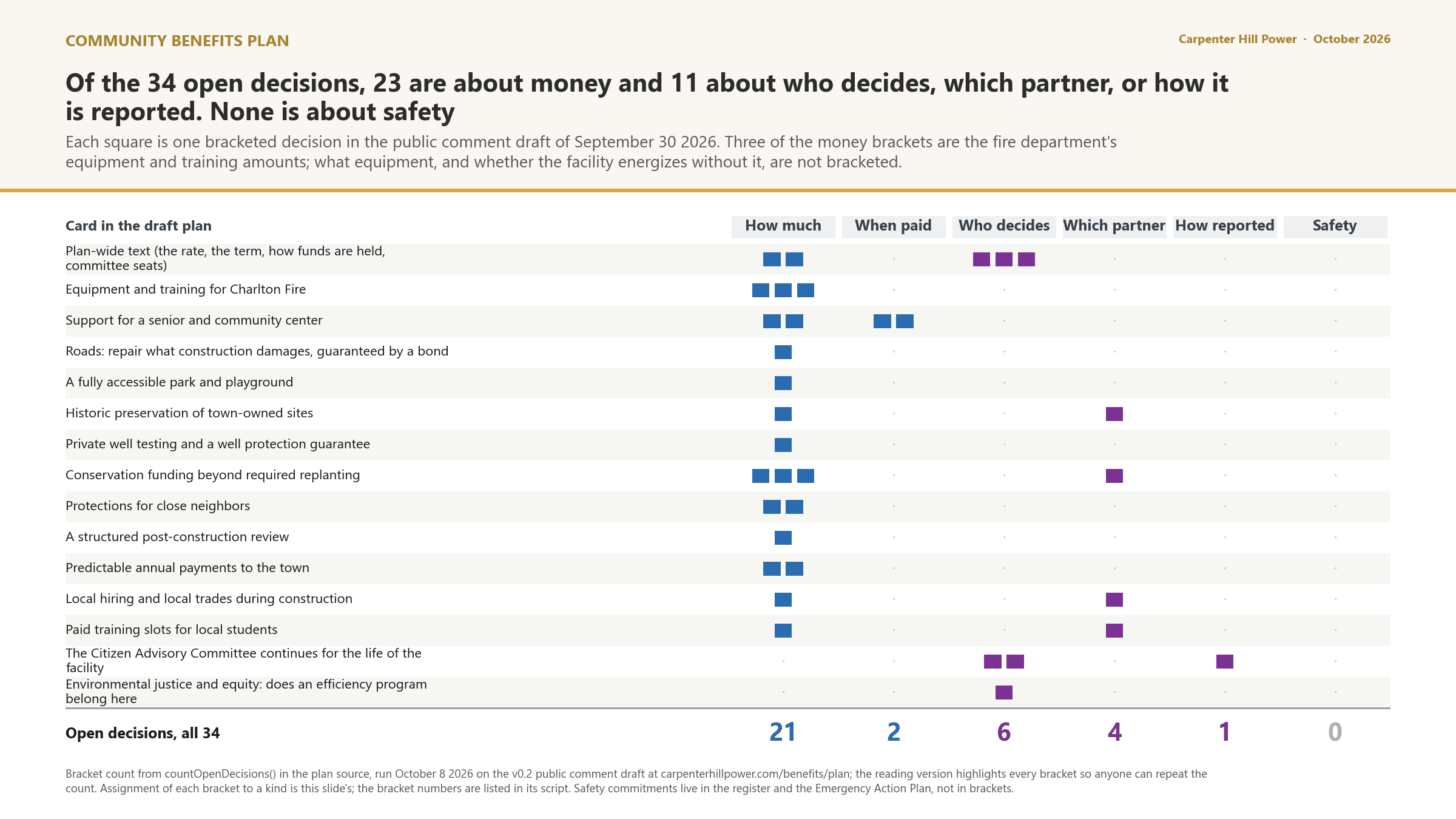
Figure 18. What the 34 open decisions in the draft Community Benefits Plan are about, as of October 2026. None is a safety question.
The project has been writing a Community Benefits Plan with a Citizen Advisory Committee since June 3, 2026, following the Office of Environmental Justice and Equity's Standards and Guidelines for Community Benefit Plans and Agreements. The working draft, version 0.1, went to the committee on September 10, 2026. Version 0.2 was published as the public comment draft at the September 30 public forum, and comment runs through November 30, 2026. It groups what residents have raised into the state's four categories, writes each proposed commitment as an outcome with a measure, a duration, a decision-maker, a funding source and a remedy, and lists the mitigation the permits already require separately so that none of it is counted as a benefit. The priorities most connected to the Elevated Indicators are fire readiness, well protection and the town's finances. Whether any of the plan becomes a signed Community Benefits Agreement is a decision for the Town of Charlton and the project together; the statute requires the project to pursue a plan, and the Board gives a plan or an agreement due weight under 980 CMR 15.11(3). The plan is linked at the end of this report.
CIA Report Template Part VIII; 980 CMR 15.11
Conclusion, and what would change it
On the record so far, the project is not expected to materially exacerbate any of the 16 Elevated Indicators in block group 250277561012 in construction or in operation, so no Disproportionate Adverse Effect is identified and no Remedial Action is required under 980 CMR 15.08. That conclusion is preliminary, and this section says exactly what it rests on.
What the conclusion depends on.
| Open study | Elevated Indicators it bears on | When | What changes if it goes the other way |
|---|---|---|---|
| Fire protection engineering report and hazard mitigation analysis, with the unit-specific UL 9540A test report | Wildfire risk; pollution cleanup sites; groundwater threats | With the Application | The wildfire risk row becomes a finding, and the fire and containment measures become Remedial Actions under 980 CMR 15.08 with costs stated. |
| Sound study against the MassDEP noise policy | Adult high blood pressure; coronary heart disease | In progress; screening model posted, professional study before the Application | A layout change, a barrier or an equipment specification, logged on the tracker, before the Application. |
| Geotechnical borings, then the final stormwater and containment design | Groundwater threats; impaired water bodies; flood risk | Borings after the pre-filing engagement period, before the Application; design with the Application | Foundation, dewatering, recharge and liner design follow the results. A pad relocation is logged with the reason. |
| Field wetland delineation, MESA review, alternatives analysis | Impaired water bodies; habitat (not an Elevated Indicator) | Delineation after the pre-filing engagement period, before the Application; MESA request and alternatives analysis before the Application | The buffer overlap and the habitat line are confirmed by survey rather than by mapping. |
| Door-to-door well survey within half a mile | Groundwater threats | Not yet started | The 16 unplaced well records are located and the screen is re-run. |
Under 980 CMR 15.11 the Board assesses the adequacy of this analysis, makes its own finding on whether the project has given due consideration to cumulative impact and has adequately avoided, minimized or mitigated any Disproportionate Adverse Effect, considers the Community Benefits Plan, and may add enforceable conditions. The project's part is to bring the Board a record it can rely on. This working draft is the first version of that record; it is updated when the studies above finish, shared again with Key Stakeholders, and filed in final form with the Application in early 2027.
980 CMR 15.07(4) and 15.04(6); OEJE guidance Part VI
Community input, and how to take part
The rule requires the project to gather community input during pre-filing and address it in this report. The guidance says lived experience is data. This section records what residents and officials have raised that bears on the analysis, where the record of it lives, and the two ways a reader can change what this report says.
What the community has raised that bears on the Elevated Indicators, and where it is answered.
| Raised | Where and when | Indicators it bears on | Where it is answered |
|---|---|---|---|
| Private well contamination and groundwater | Planning Board, June 3, 2026; public meeting, July 8; Citizen Advisory Committee, August 4 | Groundwater threats; pollution cleanup sites | Sections 5 and 6; the well screen and inventory; the groundwater monitoring commitment; the well protection proposals in the draft plan. |
| Runoff to neighbours and waterways, after problems at earlier solar projects in town | Public meeting, July 8 | Impaired water bodies; flood risk | Sections 5 and 6; erosion controls and the southern swale on the tracker. |
| Fire, thermal runaway and the department's readiness | Select Board, April 14; every meeting since; Fire Safety Webinar, August 19 | Wildfire risk; premature mortality; pediatric asthma | Section 6; the Emergency Action Plan and the fire water commitments; the fire readiness proposals in the draft plan. |
| Cumulative burden: the town already hosts a gas plant, a landfill and cleanup sites | Select Board, April 14; Citizen Advisory Committee, June 3 | The score itself | Section 4, which shows what sits behind the 80.9 and that none of it is on the parcel; Section 8. |
| Noise at the nearest homes | Public meeting, July 8 | Adult high blood pressure; coronary heart disease | Section 6; the sound study commitment. |
| Property values and the town's finances | Planning Board, June 3; public meeting, July 8 | Poverty; adults without a high school diploma | Section 8; the tax analysis and the neighbour protection proposals in the draft plan. |
| Smoke settling on Gillespie Road, fire department staffing, a single road out, and the open decisions in the draft plan | Public comment, October 5 and 8, 2026 | Wildfire risk; premature mortality; pediatric asthma | Section 6, the terrain and wind screen and the fire record; Section 8 for the open decisions; the Emergency Action Plan for staffing and access. |
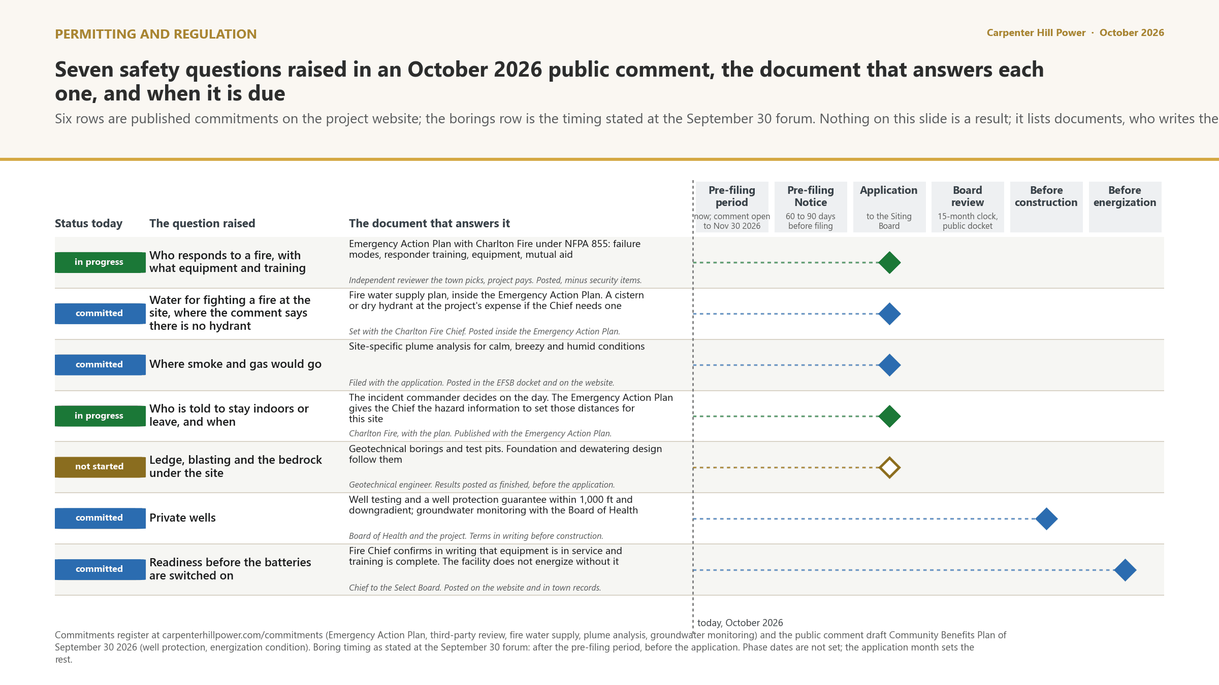
Figure 19. Seven safety questions raised in public comment, the document that answers each one, and the point in the process where it is due.
Two ways to change this report
Tell us what it is missing. The state's guidance says extraordinary local conditions, a source not in the data, or an error in the underlying data are all reasons to look again. Send it to the contact below, raise it at a meeting, or use the comment form on this site. We check it, answer on the Engagement Log, and revise this report if it changes an answer.
Petition for a full analysis of a neighbouring block group. Under 980 CMR 15.04(6), ten or more residents or businesses of a block group that intersects the SGA but is not a Burdened Area, at least one of them a Key Stakeholder, may ask the project during pre-filing to analyse that block group as if it were one, with a copy to the Director of the Division of Public Participation and the Director of the Siting Board. If the project declines, the group may petition the Director within 14 days after the Application is filed, stating the extraordinary circumstances. Block group 250277561013 is the one this applies to, and this draft already analyses it voluntarily.
Translation, interpretation or another accommodation for any meeting about this analysis is available on request. The Language Demographic Analysis of September 4, 2026 found no language spoken by five percent or more of the population within a mile who also speak English less than very well, and the project provides Spanish and Portuguese on this site voluntarily.
CIA Report Template Appendix A and B
Sources, methods and terms
The indicator definitions and sources are the state's, from Appendix A of the CIA Report Template and the MassEnviroScreen technical documentation. The method for deciding whether an impact is material is the template's Appendix B, applied row by row in Sections 5 and 6.
How materiality was judged
For each Elevated Indicator and each phase, the analysis asked the template's Appendix B questions in order: whether construction or operation would likely exceed a public health, environmental or climate standard; whether a casual observer would notice the impact; whether it can be measured; how long and how often it occurs; whether it would extend the burden beyond its present geographic extent; how it affects the ability of the indicator to absorb and recover from disturbance; whether it affects social, economic or cultural conditions or public health; and whether contamination could migrate on or off site by air, ground or water. An impact was called material only if the answers pointed to a lasting, measurable worsening of the condition the indicator measures. Where the answer depends on a study that is not finished, the row says so and the conclusion is conditional.
The indicators and their sources, from Appendix A of the CIA Report Template.
| Indicator | What it measures | Source |
|---|---|---|
| PM2.5 | Annual average fine particulate concentration | U.S. EPA |
| Ozone | Maximum 8-hour average modelled ground-level ozone | U.S. EPA |
| Nitrogen dioxide | Annual average NO2 at 1 km, aggregated to block groups | NASA |
| Diesel particulate matter | Diesel PM concentration in air | EJScreen 2024 |
| Drinking water non-compliance | Safe Drinking Water Act compliance score of the community water system serving the block group | EJScreen 2024 |
| Air toxics cancer risk; respiratory hazard index | Lifetime inhalation cancer risk; non-cancer respiratory hazard ratio | U.S. EPA |
| Proximity to heavy traffic | Heavy traffic proximity index | EJScreen 2024 |
| Pollution cleanup sites | Weighted count of cleanup sites under federal or state oversight | U.S. EPA; MassGIS |
| Groundwater threats | Weighted count of groundwater threats | U.S. EPA; MassGIS |
| Hazardous waste generators and facilities; solid waste sites | Weighted counts | MassGIS |
| Impaired water bodies | Count of pollutants across impaired waters in the area | MassGIS |
| Drought | Weekly share of area in severe to exceptional drought, 2019 to 2024 | U.S. Drought Monitor |
| Wildfire risk | Mean wildfire hazard potential | USDA; U.S. Forest Service |
| Flood risk | Share of area with at least a one percent annual chance of flooding | FEMA; MassGIS |
| Extreme heat days | Days at or above 85 degrees, May to September, 2015 to 2024 | Oregon State University |
| Premature mortality; elevated blood lead; pediatric asthma | Age-adjusted rate; five-year childhood prevalence; school-enrollment prevalence | MassDEP |
| Adult cancer, COPD, coronary heart disease, high blood pressure | Modelled adult prevalence | CDC PLACES |
| Low birth weight infants | Share of live births under 2,500 grams | State data; no value published for these block groups |
| Education, poverty, linguistic isolation, unemployment, median income | American Community Survey five-year estimates, 2019 to 2023 | U.S. Census Bureau |
| Housing-burdened low-income households | Share of households both low income and paying over half of income for housing | U.S. HUD |
MassEnviroScreen, February 27, 2026 build
Executive Office of Energy and Environmental Affairs, Office of Environmental Justice and Equity. Block group scores and all 30 indicator percentiles read from the state's feature service (MassEnviroScreen20260227_gdb) on September 8, 2026 for block groups 250277561012 and 250277561013; component ranks computed against all 5,109 Massachusetts block groups.
980 CMR 15.00
Cumulative Impact Analysis and Standards for Applying Site Suitability Criteria, Energy Facilities Siting Board, effective May 8, 2026.
CIA Report Template and Instructions
Energy Facilities Siting Board, current version retrieved August 26, 2026 from the EFSB Permitting Dashboard. Tables 1 to 10 and Appendices A and B in this report follow it.
Standards and Guidelines for Cumulative Impact Analysis
Office of Environmental Justice and Equity, April 2026. In the Document Library.
Site plan G101 revision 16
June 10, 2026. Facility Boundary components measured from the matching CAD export.
MassGIS and federal layers
Pulled September 2 to 4, 2026, including the MassDEP Chapter 21E, AUL, major facility, landfill and 2022 Integrated List layers over the block group's extent; census block groups from TIGERweb 2020; FEMA National Flood Hazard Layer; NHESP and BioMap habitat; wellhead protection areas.
Terrain, soils, drainage and wells
September 3, 2026 analysis on MassGIS 2013 to 2021 bare-earth LiDAR, NRCS SSURGO soils and the MassDEP Well Driller Program database. Desktop findings on published mapping; survey and borings govern.
Interagency consultation
Convened by the Division of Public Participation on September 4, 2026, with staff of DPU, EEA, the MEPA Office, MassDEP and MassWildlife. The project's notes are the source for the agency requests cited here.
Community input
The Engagement Log on this site: Select Board April 14, 2026; Citizen Advisory Committee June 3 and August 4; Planning Board June 3; public meeting July 8; Citizen Advisory Committee September 10; Fire Safety Webinar August 19; Old Home Day September 6; Community Public Forum September 30; written public comment October 5 and 8.
Draft Community Benefits Plan
Version 0.2, public comment draft of September 30, 2026, on this site.
US grid battery fire record
The project's database of US grid-scale battery incidents from 2018 to July 2026, built on the EPRI BESS Failure Incident Database and public incident reports, with a response and sampling table compiled October 9, 2026 from the reports of the agencies that monitored each fire, including two September 2026 events. Totals are floors: a fire with no public record of the response is not counted.
Terrain, wind and downhill pathway screen
October 6 to 9, 2026. USGS 3DEP elevation over a two-mile window; non-rising walks from the pad and from Gillespie Road; the land draining to each point on the downhill path by priority-flood fill and D8 routing; MassDEP wetlands and MassGIS building footprints. Wind from Worcester Regional Airport observations 2016 to 2025 through the Iowa Environmental Mesonet; a hilltop station 11 miles away, so the still-air shares are a floor. No dispersion model was run, by decision; the plume analysis is a commitment for the final design.
Initial sound study, screening level
September 6, 2026, revision 1. ISO 9613-2 general method, downwind, leaf-off, with LiDAR terrain screening at every receptor; the Megapack 2 XL octave-band data as a stand-in for the Megapack 3; no measured background. Preliminary, built by the project team and not reviewed or confirmed by a sound engineer; replaced by the professional sound study against the MassDEP noise policy.
Terms used in this report
- Cumulative Impact Analysis (CIA)
- The process by which an applicant identifies, considers and addresses the combined effect of past and present activities plus the proposed project on the environment, public health and climate resilience in a Burdened Area (980 CMR 15.02).
- Specific Geographical Area (SGA)
- The area within a fixed distance of the Facility Boundary, set by facility type in 980 CMR 15.05(1). One mile for a clean energy storage facility.
- Facility Boundary
- The outermost boundary of the project site, such as the outermost area of construction or disturbance or the fence line, and for a linear component the edge of the right of way (980 CMR 15.02).
- Burdened Area
- A census block group with a MassEnviroScreen score of 75 or more, or a median household income of 65 percent or less of the state median (980 CMR 15.04(1)).
- MassEnviroScreen
- The state's screening tool, maintained by the Office of Environmental Justice and Equity, that scores every census block group on 30 indicators and produces a cumulative burden percentile.
- Indicator
- One statistical measure of environmental exposure, environmental effect, climate risk, sensitive population or socioeconomic condition in a block group, expressed as a statewide percentile.
- Elevated Indicator
- For a clean energy facility, an indicator above the 50th percentile statewide, identified only where the SGA intersects a Burdened Area (980 CMR 15.02).
- Project Impact
- An effect, positive or negative, on the environment, socioeconomic or public health conditions, or climate resilience, from construction or operation of the project.
- Disproportionate Adverse Effect
- A Project Impact likely to materially exacerbate an Elevated Indicator in a Burdened Area intersecting the SGA, after positive and negative impacts are weighed, with a net negative result (980 CMR 15.02).
- Remedial Action
- An action that avoids, minimizes or mitigates a Disproportionate Adverse Effect (980 CMR 15.08).
- Benefit
- A positive effect on public health, the environment or climate resilience with a geographic, economic, public health or scientific nexus to the overlap of the Burdened Area and the SGA (980 CMR 15.02).
- Key Stakeholder
- Abutters, community organizations, municipal and regional officials, labor and apprenticeship representatives, and Tribes, as 980 CMR 16.02 lists them.
- Category 5 water
- A water body on the state's Integrated List that is impaired and needs a pollutant budget (a TMDL).
- UL 9540A
- The test method for evaluating thermal runaway fire propagation in battery energy storage systems.
- NFPA 855
- The National Fire Protection Association standard for the installation of stationary energy storage systems, applied through the state fire code.
- SPCC plan
- A Spill Prevention, Control and Countermeasure plan under federal oil pollution rules, for a site that stores oil above the threshold.
Questions about this report
Jonathan Santiago, Project Development Associate, ESA Solar. jsantiago@esa-solar.com or 407-232-7440 ext. 251.
Translation, interpretation, or another accommodation for any meeting about this report is available on request.
The live version of this report, the slides, every map in it at full size, the Commitment Tracker, the Engagement Log, and every document it rests on are at carpenterhillpower.com/reports/cumulative-impact. When a version of this report is replaced, the old one stays readable, with the date it changed and the reason.
Related
- Site Suitability Analysis: carpenterhillpower.com/reports/site-suitability
- Slide Library: every figure in this report at full size: carpenterhillpower.com/slide-library
- Draft Community Benefits Plan: carpenterhillpower.com/benefits/plan
- Engagement Log: what people asked and what we said: carpenterhillpower.com/engagement-log
- Commitment Tracker: carpenterhillpower.com/commitments
- State Standards and Guidelines for Cumulative Impact Analysis (April 2026): carpenterhillpower.com/documents
- How We Follow the Siting Rules: carpenterhillpower.com/siting-rules
Carpenter Hill Power, LLC · 131 Carpenter Hill Road, Charlton, Massachusetts · Preliminary draft v0.4 · October 11, 2026