Cumulative Impact Analysis · Preliminary draft v0.4
Cumulative Impact Analysis
980 CMR 15.00 · October 11, 2026
Follow along at carpenterhillpower.com/reports/cumulative-impact
Before we start
What this report found
The one-mile Specific Geographical Area intersects one Burdened Area, block group 250277561012, which scores 80.9 on MassEnviroScreen against a threshold of 75 and contains every component of the project.
Sixteen of the block group's 29 scored indicators are Elevated Indicators. The score is carried by legacy contamination and impaired streams around the block group, none of it on the parcel.
Preliminary finding: the project is not expected to materially exacerbate any Elevated Indicator in construction or operation, so no Disproportionate Adverse Effect is identified. The finding is conditional on the fire protection, sound and stormwater studies.
The neighbouring block group, scoring 73.0, is analysed voluntarily, and residents of it can petition for a full analysis.
The full report is at carpenterhillpower.com/reports/cumulative-impact; every slide here is derived from it.
Contents
What is in this report
1 · Summary
2 · The Specific Geographical Area
3 · Burdened Areas intersecting the SGA
4 · Elevated Indicators
5 · Construction phase: project impacts on the Elevated Indicators
6 · Operations phase: project impacts on the Elevated Indicators
7 · Avoidance, minimization and mitigation
8 · Project benefits and the Community Benefits Plan
9 · Conclusion, and what would change it
10 · Community input, and how to take part
11 · Sources, methods and terms
What a Cumulative Impact Analysis is, and what this one found so far
Summary
A Cumulative Impact Analysis asks one question in five steps: does this project add to burdens a community already carries? The site sits in a census block group the state has designated a Burdened Area, so every step applies. This working draft records the steps taken, the preliminary answer to each, and what still has to happen before the answer is final.
The one-mile Specific Geographical Area intersects one Burdened Area: block group 250277561012, MassEnviroScreen score 80.9 against a threshold of 75.
Sixteen of the block group's 29 scored indicators are Elevated Indicators, above the 50th percentile statewide.
The score is carried by legacy contamination and impaired streams around the block group, not by measured pollution exposure. None of the sites that drive it is on the parcel.
Preliminary finding: no Disproportionate Adverse Effect is identified in either phase, conditional on the studies still open, and wildfire risk, groundwater threats, pollution cleanup sites and the two noise-linked health indicators are the rows that wait on them.
Neighbouring block group 250277561013, scoring 73.0, is analysed voluntarily.
CIA Report Template Part I; 980 CMR 15.05(1)
The Specific Geographical Area
The Specific Geographical Area, or SGA, is the ground the analysis examines. It is drawn as a fixed distance from the Facility Boundary, and the distance depends on the kind of facility. For a clean energy storage facility it is one mile.
One proposed site, no noticed alternative: parcel 43-A-1 at 131 Carpenter Hill Road, Charlton.
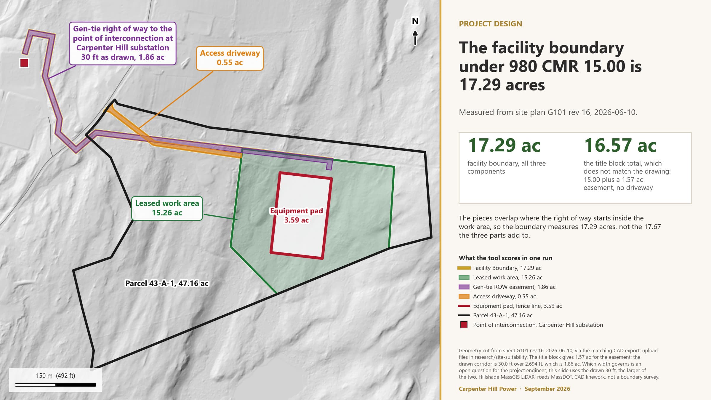
The Facility Boundary is 17.29 acres: the BESS project area, the gen-tie easement and the driveway, merged.
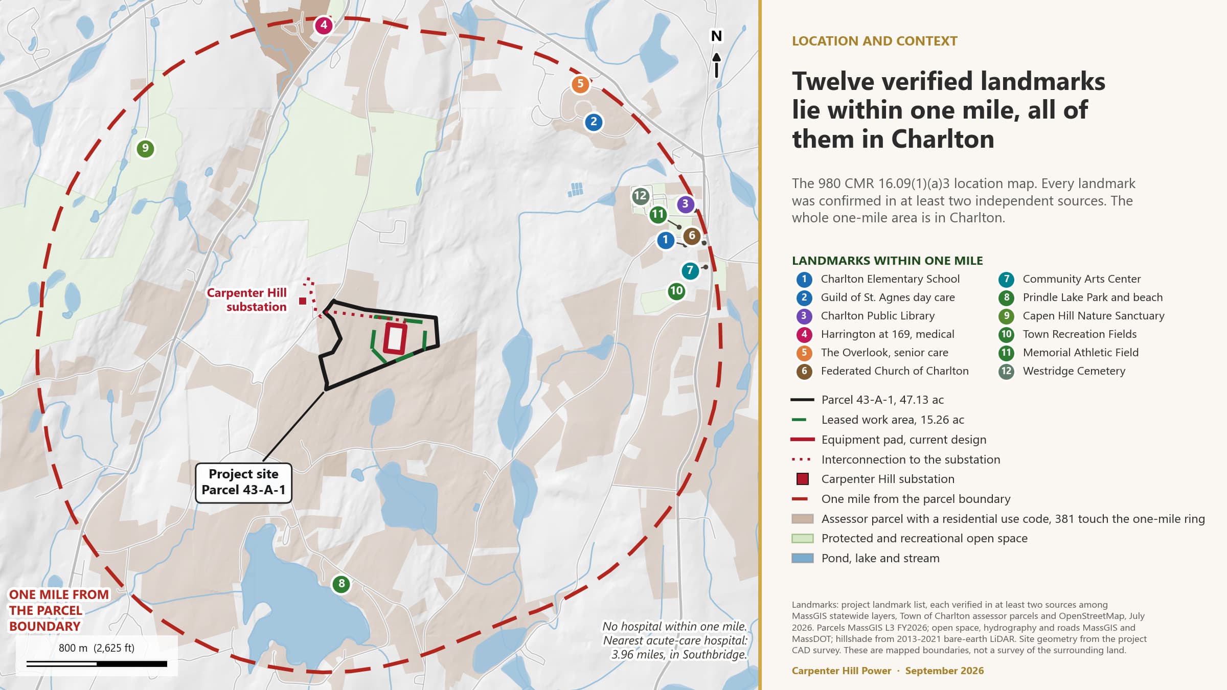
The SGA is everything within one mile of that boundary, about 2,770 acres, all of it in Charlton.
The gen-tie is scored as a component of the storage facility, so the one-mile distance applies to all of it.
2 · The Specific Geographical Area · Figure 1
The facility boundary for the state suitability tool
2 · The Specific Geographical Area · Figure 2
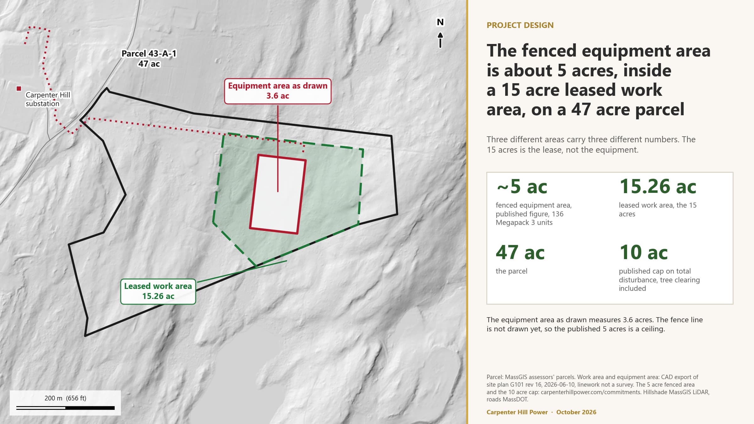
Parcel, leased work area and equipment area
2 · The Specific Geographical Area · Figure 3
Project location and landmarks within one mile
CIA Report Template Part II; 980 CMR 15.04 and 15.05(2)
Burdened Areas intersecting the SGA
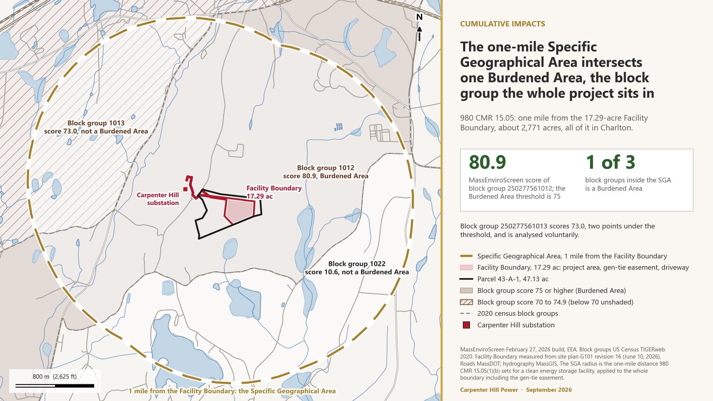
A Burdened Area is a census block group with a MassEnviroScreen score of 75 or more, or a median household income of 65 percent or less of the state median. Three block groups lie inside the one-mile SGA. One of them qualifies, and it is the one the whole project sits in.
Block group 250277561012 contains every component of the project and scores 80.9. It is a Burdened Area on the score alone.
It qualifies on the score, not on income: median household income is about 82 percent of the state median.
Block group 250277561013, inside the SGA, scores 73.0, two points under the threshold. It is analysed voluntarily.
Block group 250277561022 scores 10.6. No other block group is within a mile.
3 · Burdened Areas intersecting the SGA · Figure 4
The Specific Geographical Area and the Burdened Area it intersects
CIA Report Template Part III; 980 CMR 15.06
Elevated Indicators
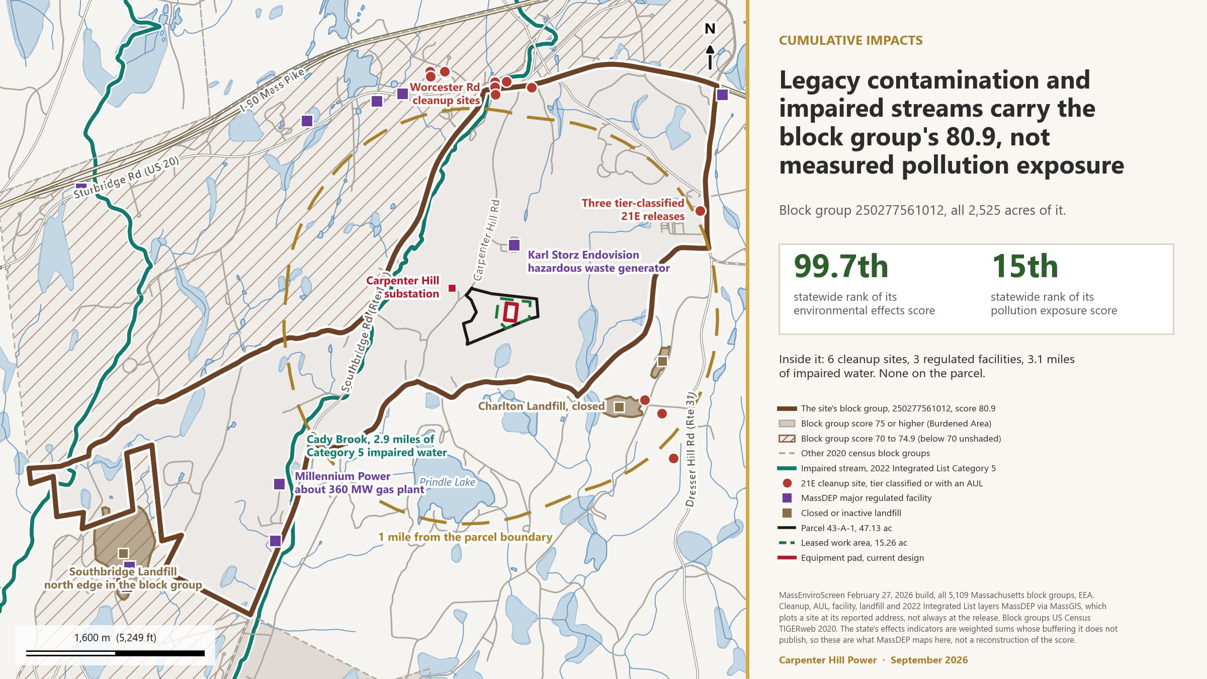
MassEnviroScreen scores every block group on 30 indicators, each as a percentile against every other block group in the state. For a clean energy facility, an indicator above the 50th percentile is an Elevated Indicator, and the project has to assess its effect on each one. The host block group has 16.
The environmental effects component scores 86.0, the 99.7th percentile of 5,109 block groups. Pollution exposure scores 23.3, the 15th.
All five effects indicators are above the 80th percentile: cleanup sites, groundwater threats, solid waste, impaired waters, hazardous waste.
Chronic disease prevalence is the second driver: adult cancer, high blood pressure, heart disease, COPD, premature mortality.
Wildfire risk at 77.6 and flood risk at 54.3 are the two elevated indicators most closely coupled to this technology.
Not elevated: traffic, nitrogen dioxide, diesel particulate matter, air toxics, drinking water non-compliance, heat, drought.
4 · Elevated Indicators
What sits behind the effects score
The effects indicators are weighted counts of what MassDEP maps in and around the block group. None of it is on the parcel.
Six cleanup sites: Three tier-classified Chapter 21E releases filed to Mass Pike mile marker 83.8, and three activity and use limitations on Worcester Road.
Three major regulated facilities: Karl Storz Endovision, a hazardous waste generator 0.37 mile from the pad; INCOM; and the Millennium Power gas-fired plant.
3.1 miles of impaired stream: Category 5 on the 2022 Integrated List, 2.9 miles of it Cady Brook, which lies in a different drainage from the pad.
A landfill edge: 2.3 acres of the 74.7-acre Southbridge Landfill at the town line. The closed Charlton Landfill is 0.75 mile from the pad but outside the block group.
The state does not publish the buffering behind its weighted counts, so this is the character of the burden, not a reconstruction of the score.
4 · Elevated Indicators
16 Elevated Indicators in block group 250277561012 (1 of 2)
Every indicator above the 50th percentile statewide. The full table of all 30 is in the report.
| Indicator | Statewide percentile | Status | |
|---|---|---|---|
| Environmental exposures | |||
| Fine particulate matter (PM2.5) | 54.2 | Elevated | |
| Environmental effects | |||
| Pollution cleanup sites | 90.8 | Elevated | |
| Groundwater threats | 88.4 | Elevated | |
| Hazardous waste generators and facilities | 81.4 | Elevated | |
| Solid waste sites and facilities | 85.6 | Elevated | |
| Impaired water bodies | 83.7 | Elevated | |
| Climate risks | |||
| Wildfire risk | 77.6 | Elevated | |
| Flood risk | 54.3 | Elevated | |
4 · Elevated Indicators
16 Elevated Indicators in block group 250277561012 (2 of 2)
| Indicator | Statewide percentile | Status | |
|---|---|---|---|
| Sensitive populations | |||
| Pediatric asthma | 57.0 | Elevated | |
| Premature mortality | 74.0 | Elevated | |
| Adult high blood pressure | 80.4 | Elevated | |
| Coronary heart disease | 73.0 | Elevated | |
| Chronic obstructive pulmonary disease (COPD) | 62.8 | Elevated | |
| Adult cancer | 83.3 | Elevated | |
| Socioeconomic factors | |||
| Adults without a high school diploma | 69.7 | Elevated | |
| Poverty | 64.4 | Elevated | |
4 · Elevated Indicators · Figure 5
The site's block group, its MassEnviroScreen score and what drives it
CIA Report Template Part IV.A; 980 CMR 15.07
Construction phase: project impacts on the Elevated Indicators
For each Elevated Indicator, the question is whether construction of the project would materially exacerbate the condition it measures: worsen it, leave it alone, or improve it. The test in the template's Appendix B looks at standards, perceptibility, measurability, duration, geographic extent, resilience, social and health effects, and the potential for contamination to migrate. Construction runs 12 to 18 months.
Construction impacts are temporary, local, and governed by permits with numeric limits: dust, diesel exhaust, erosion, fuel handling, waste hauling.
The pathways that reach the elevated effects indicators are a spill to soil or groundwater and sediment to the stream south of the pad. Both are covered by firm commitments.
Preliminary determination for every Elevated Indicator: no Disproportionate Adverse Effect during construction.
Two socioeconomic indicators may see a benefit, from construction employment and training.
5 · Construction phase: project impacts on the Elevated Indicators
Construction: the project's impact on each Elevated Indicator (1 of 2)
| Elevated Indicator | Project impact during construction | Disproportionate Adverse Effect? |
|---|---|---|
| Fine particulate matter (PM2.5) (54.2) | Burden, minor and temporary: dust from clearing, grading and gravel placement, and diesel exhaust from equipment and deliveries over 12 to 18 months. | No (preliminary) |
| Pollution cleanup sites (90.8) | No impact or insignificant. Construction creates no new cleanup site unless a reportable release occurs. | No (preliminary) |
| Groundwater threats (88.4) | Burden, potential and controlled: temporary dewatering in poorly drained Ridgebury soil, fuel storage, and concrete work on a site in thin till over bedrock. | No (preliminary), conditional on the geotechnical results |
| Hazardous waste generators and facilities (81.4) | No impact or insignificant. Construction generates universal waste and small quantities of used oil, handled by licensed haulers. | No (preliminary) |
| Solid waste sites and facilities (85.6) | No impact or insignificant. Cleared timber, stumps and construction debris go to permitted facilities off site. | No (preliminary) |
| Impaired water bodies (83.7) | Burden, potential and controlled: sediment from about 10 acres of disturbance could reach the unnamed stream south of the pad. | No (preliminary) |
| Wildfire risk (77.6) | Burden, minor and temporary: hot work, fuelled equipment and cleared slash in a wooded area at the 77.6th percentile for wildfire hazard potential. | No (preliminary) |
| Flood risk (54.3) | No impact or insignificant. The whole site is in FEMA Zone X, minimal flood hazard; nothing is built in a flood zone. | No (preliminary) |
5 · Construction phase: project impacts on the Elevated Indicators
Construction: the project's impact on each Elevated Indicator (2 of 2)
| Elevated Indicator | Project impact during construction | Disproportionate Adverse Effect? |
|---|---|---|
| Pediatric asthma (57.0) | Burden, minor and temporary, through the same dust and exhaust pathway as PM2.5. | No (preliminary) |
| Premature mortality (74.0) | No impact or insignificant. | No (preliminary) |
| Adult high blood pressure (80.4) | No impact or insignificant. Construction noise and traffic are the only plausible pathway, and both are temporary. | No (preliminary) |
| Coronary heart disease (73.0) | No impact or insignificant. | No (preliminary) |
| Chronic obstructive pulmonary disease (COPD) (62.8) | Burden, minor and temporary, through dust and diesel exhaust. | No (preliminary) |
| Adult cancer (83.3) | No impact or insignificant. | No (preliminary) |
| Adults without a high school diploma (69.7) | Benefit, possible: construction employment and trades training over 12 to 18 months. | No |
| Poverty (64.4) | Benefit, possible: construction wages and local spending during the build. | No |
CIA Report Template Part IV.B; 980 CMR 15.07; 2024 Climate Act clause (ii)
Operations phase: project impacts on the Elevated Indicators
In operation the facility charges and discharges batteries, burns nothing, has no stack, uses no process water and discharges no wastewater. The impacts that remain are the ones that come from the equipment itself: a credible fire event, the liquids on site, cooling fan and inverter noise, new impervious surface, and cleared forest. This section assesses each against the 16 Elevated Indicators, then asks the Climate Act's separate question about the effects of climate change.
No combustion, no stack, no process water, no wastewater discharge: the air and water exposure indicators do not move.
The credible event is a battery fire. Wildfire risk is the indicator most coupled to it, and the determination waits on the fire protection engineering report and the hazard mitigation analysis.
Transformer oil is the largest liquid inventory. Secondary containment, an SPCC plan and firewater capture are the commitments that bound the groundwater pathway.
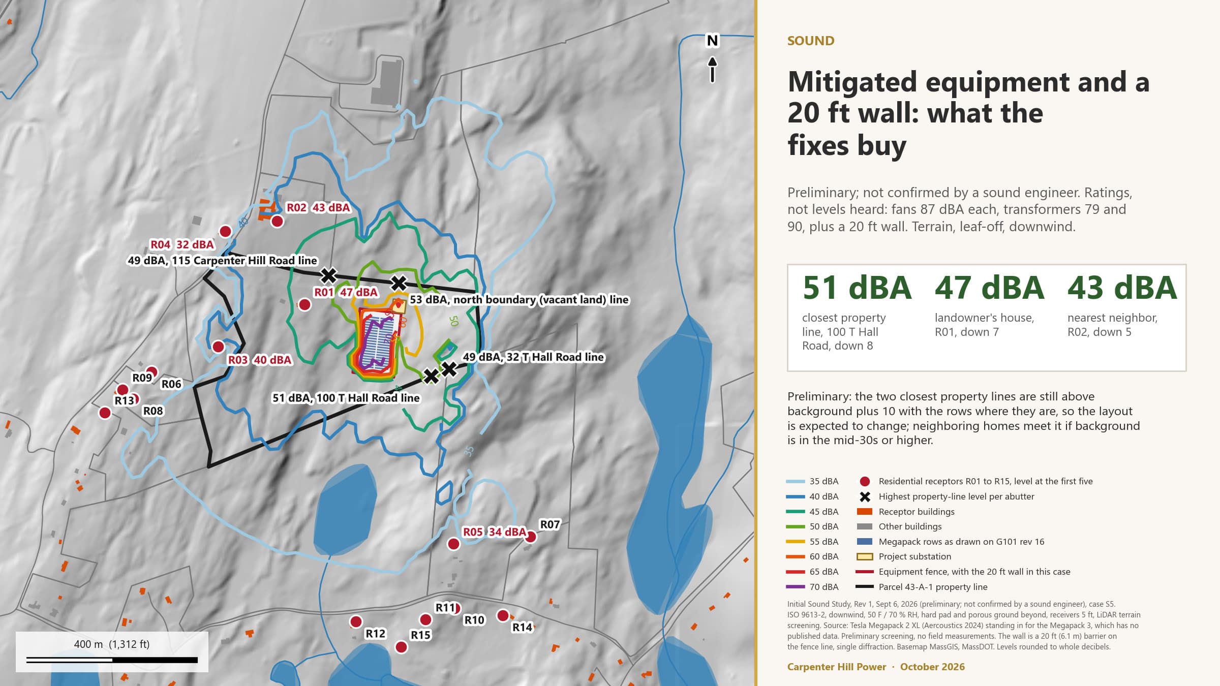
Noise is the one operating impact that reaches homes, and the design has to meet the MassDEP policy at the property line and the nearest residence.
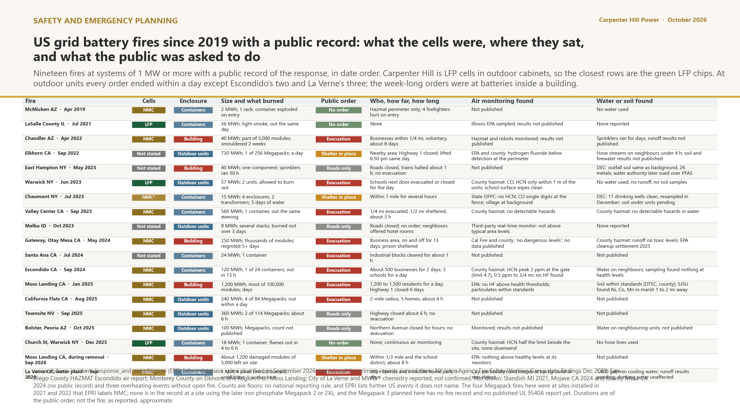
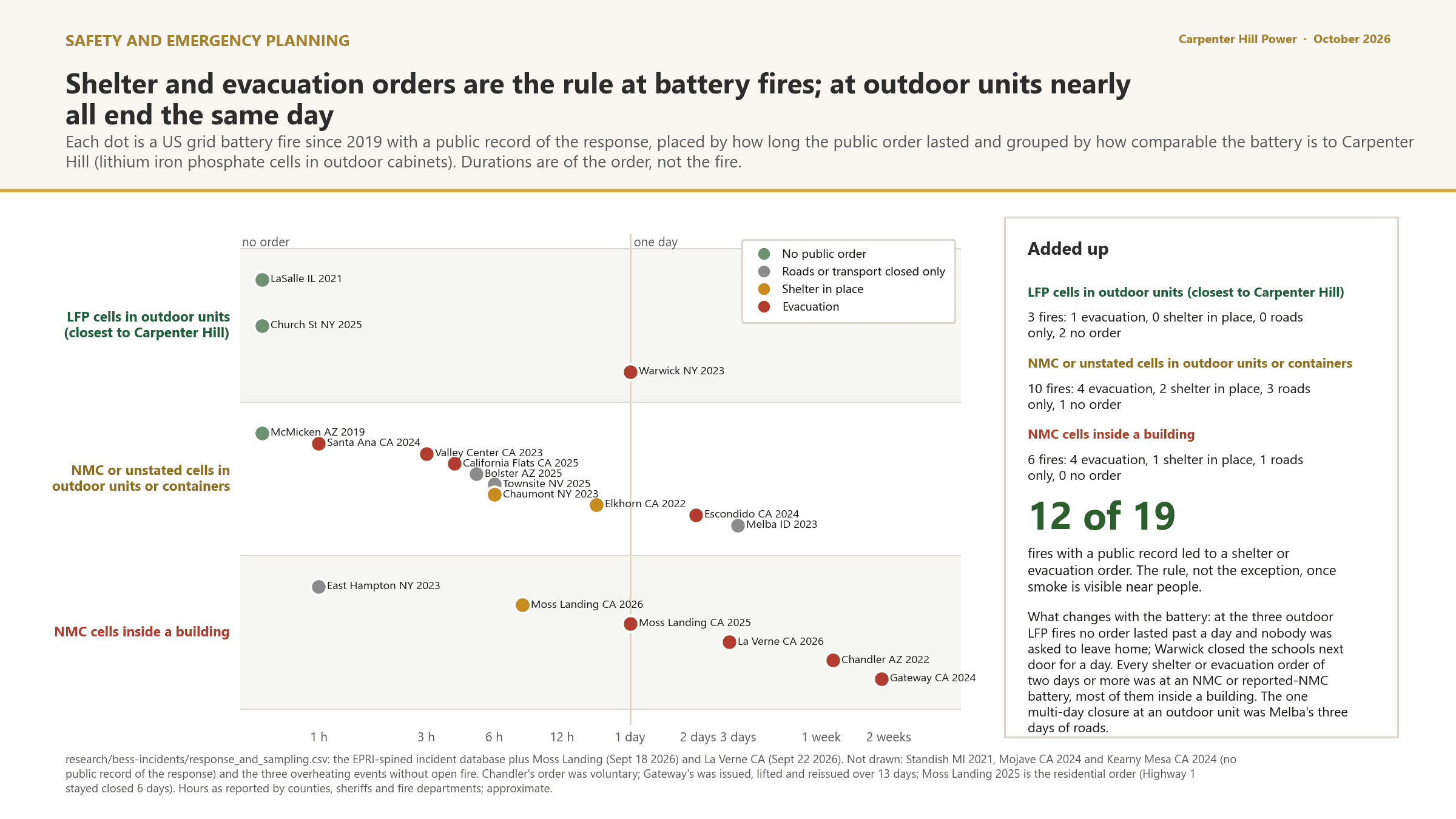
The US record of grid battery fires since 2019, sorted by what is comparable, is set down as context for the Emergency Action Plan, not as a prediction for this site.
On climate: the facility reduces the effects of climate change regionally and adds a small local heat and impervious footprint.
6 · Operations phase: project impacts on the Elevated Indicators
Operations: the project's impact on each Elevated Indicator (1 of 2)
| Elevated Indicator | Project impact during operations | Disproportionate Adverse Effect? |
|---|---|---|
| Fine particulate matter (PM2.5) (54.2) | No impact or insignificant. No combustion and no stack; a handful of maintenance vehicle trips a week. | No (preliminary) |
| Pollution cleanup sites (90.8) | No impact or insignificant in normal operation. A release from a transformer or a fire event is the pathway. | No (preliminary), conditional on the fire protection engineering report |
| Groundwater threats (88.4) | Burden, potential and controlled: liquids stored on site, new impervious surface over a shallow water table, and firefighting water in a fire event. | No (preliminary), conditional on containment design and the fire protection engineering report |
| Hazardous waste generators and facilities (81.4) | Burden, minor: the facility may register as a very small quantity generator for used oil, universal waste and any cells replaced over its life. | No (preliminary) |
| Solid waste sites and facilities (85.6) | No impact or insignificant. | No (preliminary) |
| Impaired water bodies (83.7) | No impact or insignificant, controlled: about 5 acres of new impervious surface draining to a wetland chain in a different drainage from Cady Brook. | No (preliminary) |
| Wildfire risk (77.6) | Burden, potential: thermal runaway in a battery module is the credible event for lithium-ion storage, on a forested site at the 77.6th percentile for wildfire hazard potential. | Not yet determined. Preliminary: no, conditional on the fire protection engineering report and the hazard mitigation analysis filed with the Application |
| Flood risk (54.3) | No impact or insignificant. | No (preliminary) |
6 · Operations phase: project impacts on the Elevated Indicators
Operations: the project's impact on each Elevated Indicator (2 of 2)
| Elevated Indicator | Project impact during operations | Disproportionate Adverse Effect? |
|---|---|---|
| Pediatric asthma (57.0) | No impact or insignificant. | No (preliminary) |
| Premature mortality (74.0) | No impact or insignificant. | No (preliminary) |
| Adult high blood pressure (80.4) | Burden, potential: continuous cooling fan and inverter noise at the nearest property lines and homes. | No (preliminary), conditional on the sound study |
| Coronary heart disease (73.0) | No impact or insignificant. | No (preliminary), conditional on the sound study |
| Chronic obstructive pulmonary disease (COPD) (62.8) | No impact or insignificant. | No (preliminary) |
| Adult cancer (83.3) | No impact or insignificant. | No (preliminary) |
| Adults without a high school diploma (69.7) | No impact or insignificant. A small number of operations and maintenance positions. | No |
| Poverty (64.4) | Benefit, possible: property tax or negotiated payments to the Town of Charlton over the operating life. | No |
6 · Operations phase: project impacts on the Elevated Indicators · Figure 6
US grid battery fires since 2019 with a public record: cells, enclosure, public orders, and what sampling found
6 · Operations phase: project impacts on the Elevated Indicators · Figure 7
Shelter and evacuation orders at US battery fires: how often, and how long, by battery type
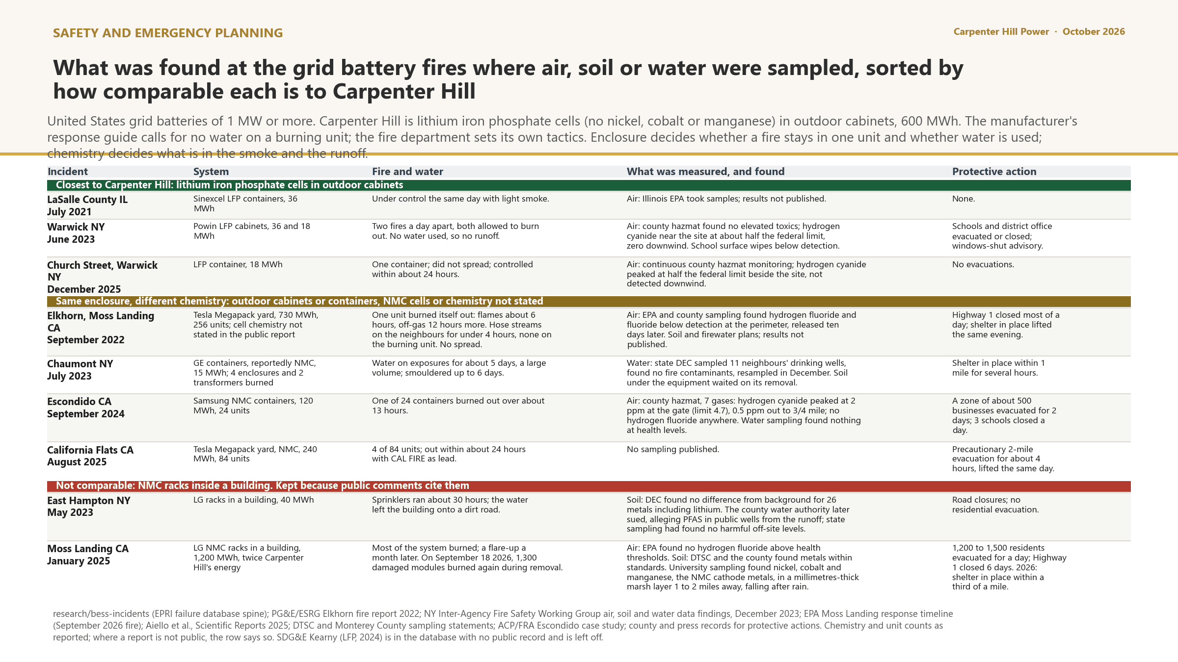
6 · Operations phase: project impacts on the Elevated Indicators · Figure 8
What reached the environment at real battery fires, by comparability
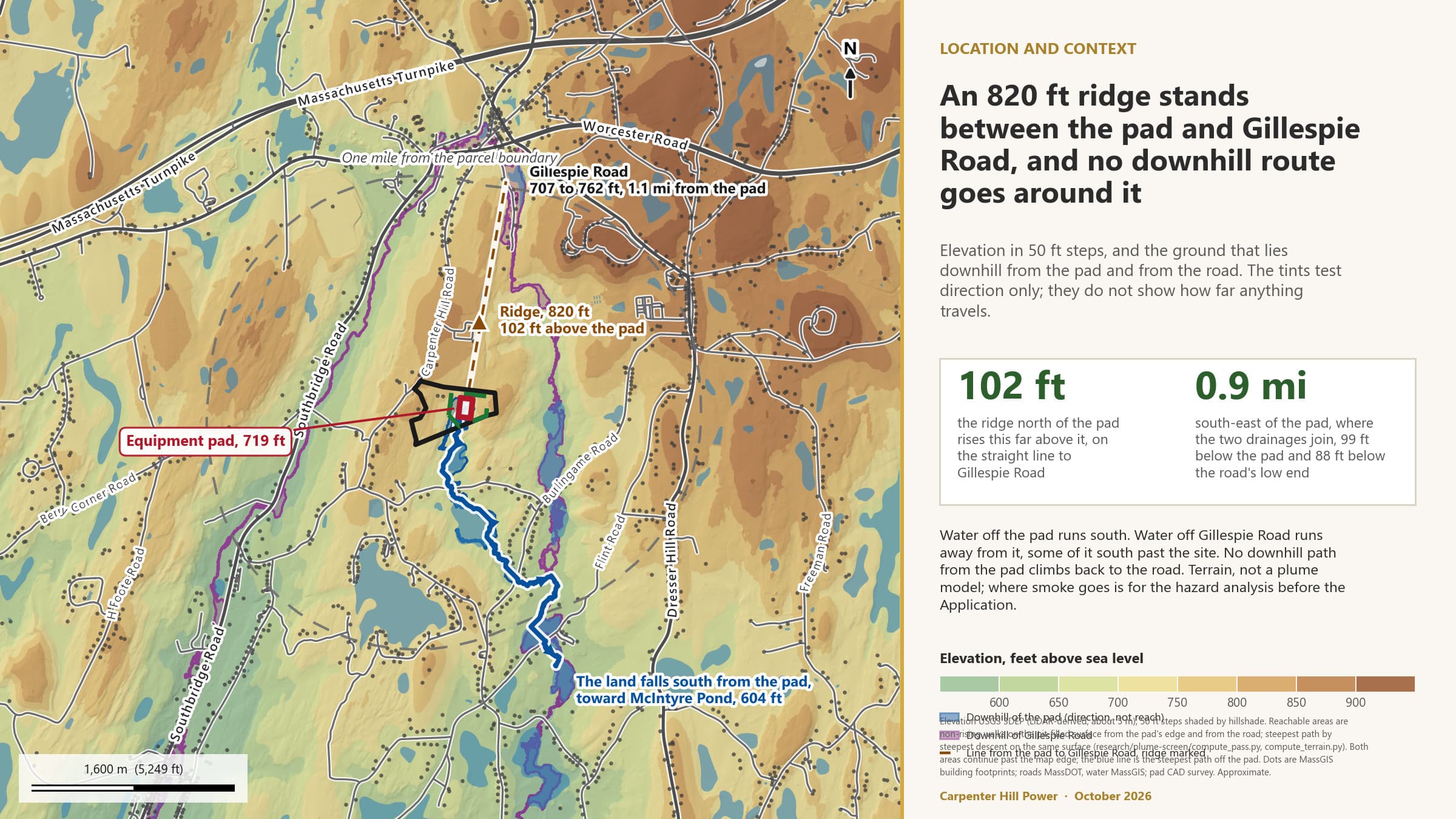
6 · Operations phase: project impacts on the Elevated Indicators · Figure 9
Where the pad drains, where Gillespie Road drains, and the ridge between them
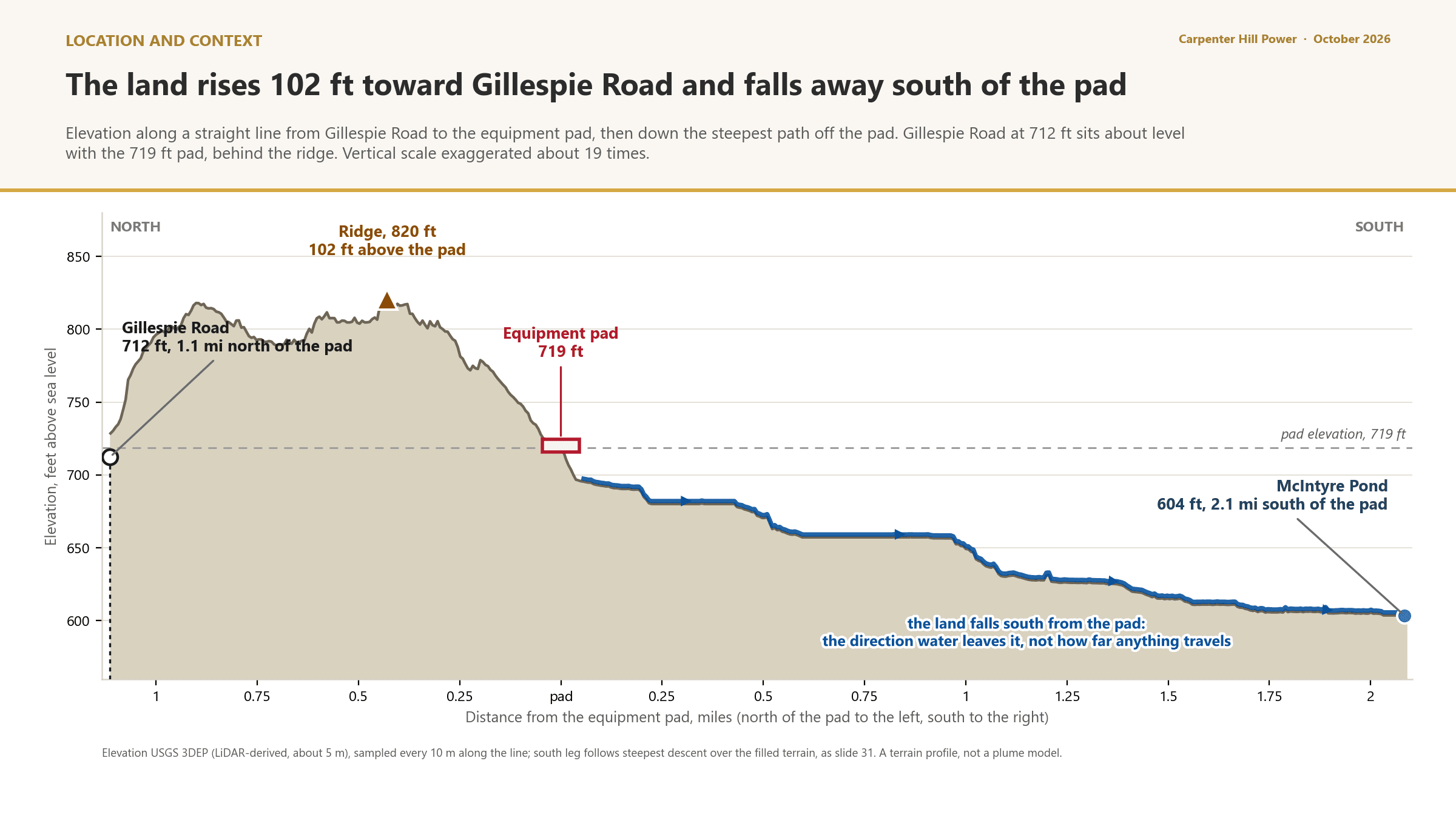
6 · Operations phase: project impacts on the Elevated Indicators · Figure 10
Elevation from Gillespie Road through the pad to McIntyre Pond
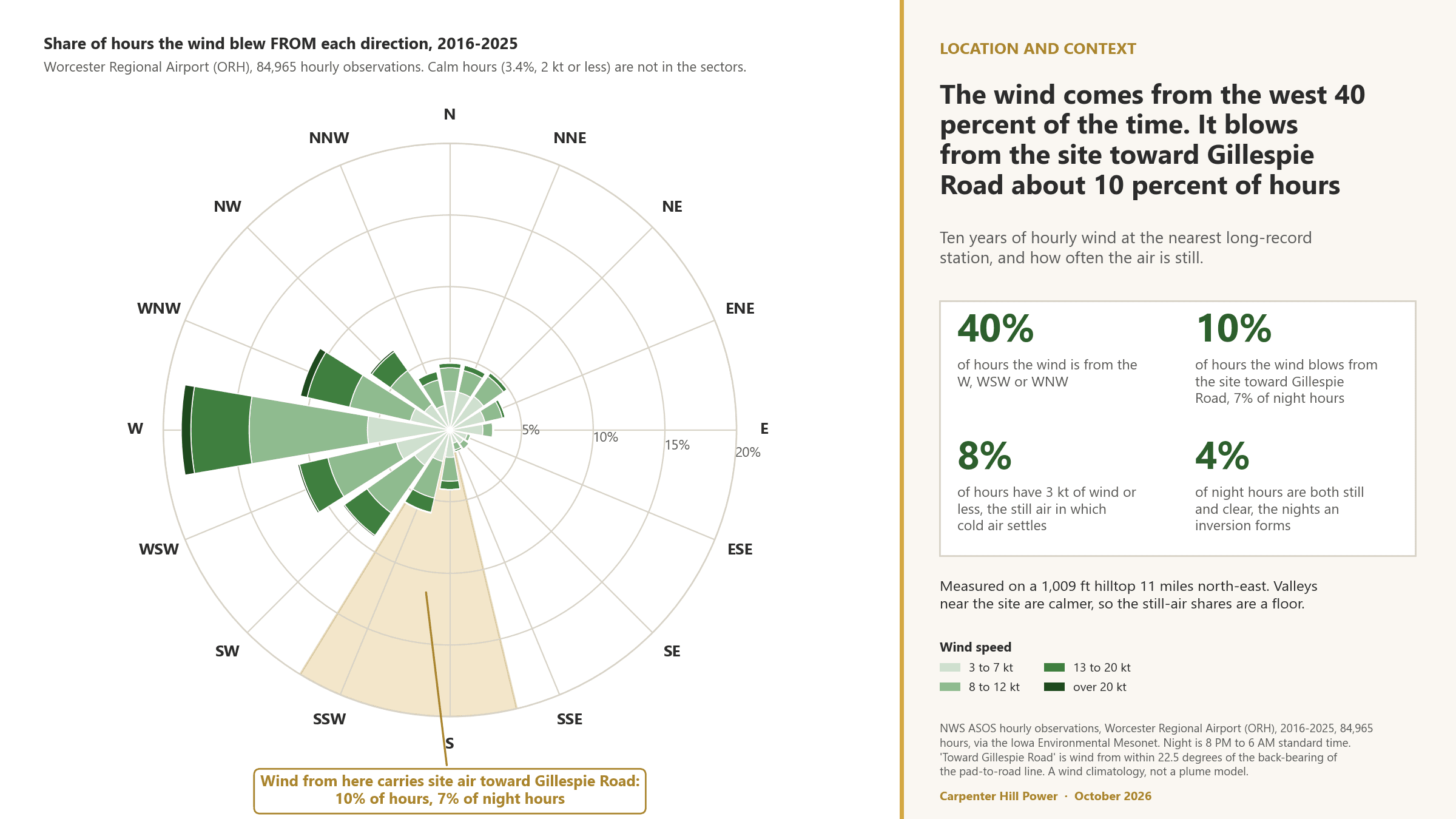
6 · Operations phase: project impacts on the Elevated Indicators · Figure 11
Which way the wind blows: ten years at Worcester Regional Airport
6 · Operations phase: project impacts on the Elevated Indicators · Figure 12
What the land does to anything that leaves the pad, stage by stage
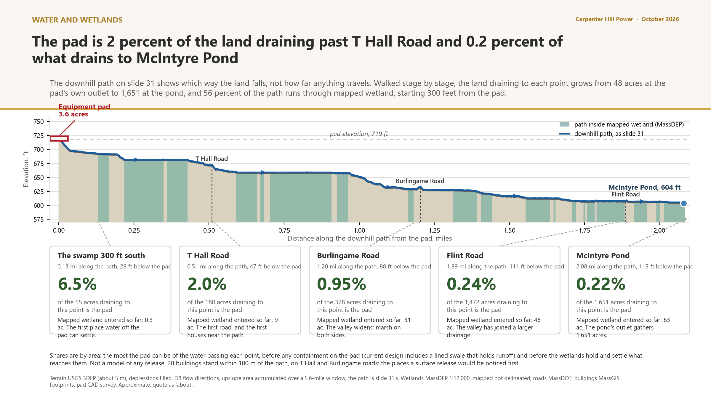
6 · Operations phase: project impacts on the Elevated Indicators · Figure 13
Modeled sound sources on the current layout
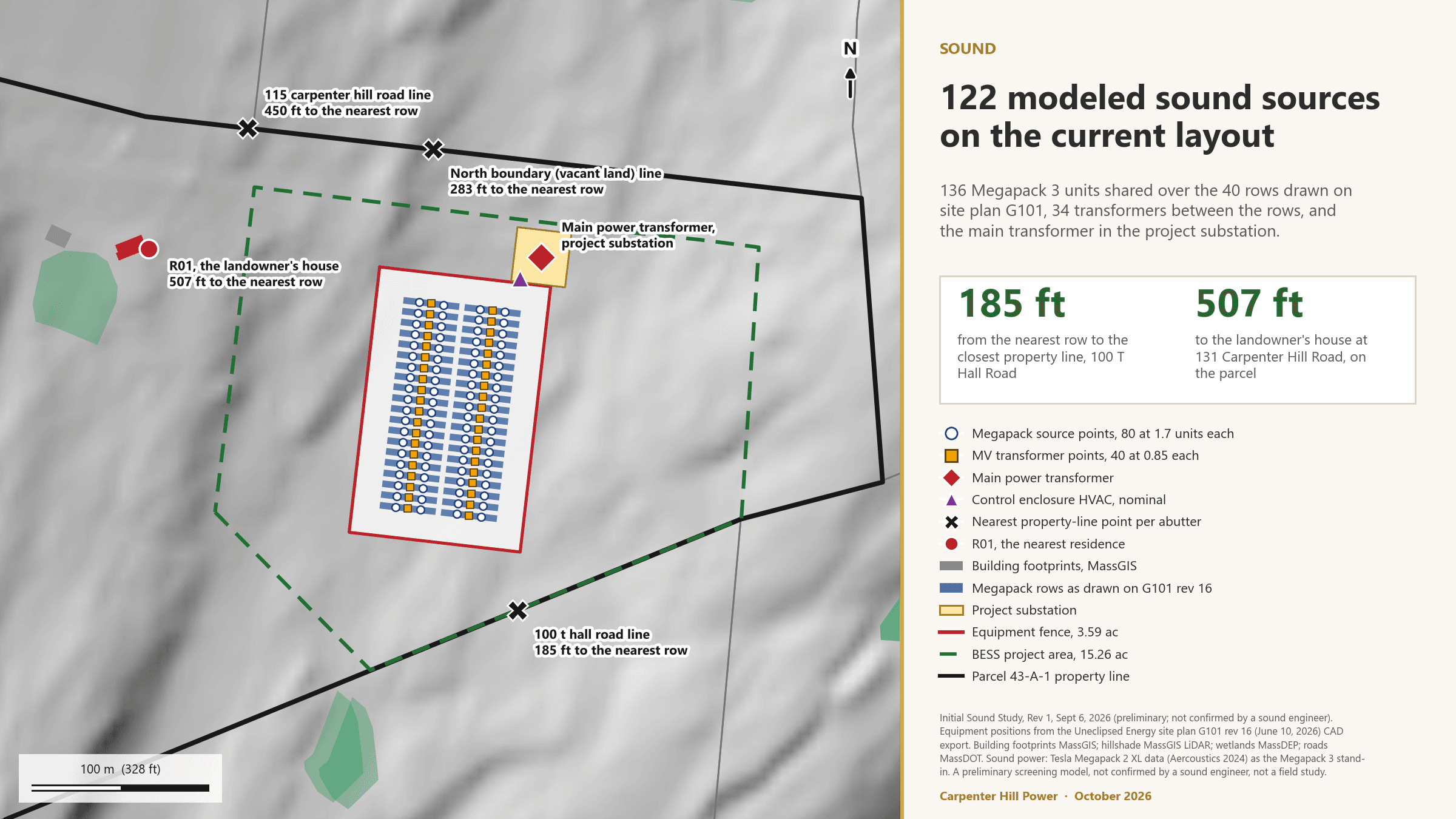
6 · Operations phase: project impacts on the Elevated Indicators · Figure 14
Receptors within one mile and the night-time contours
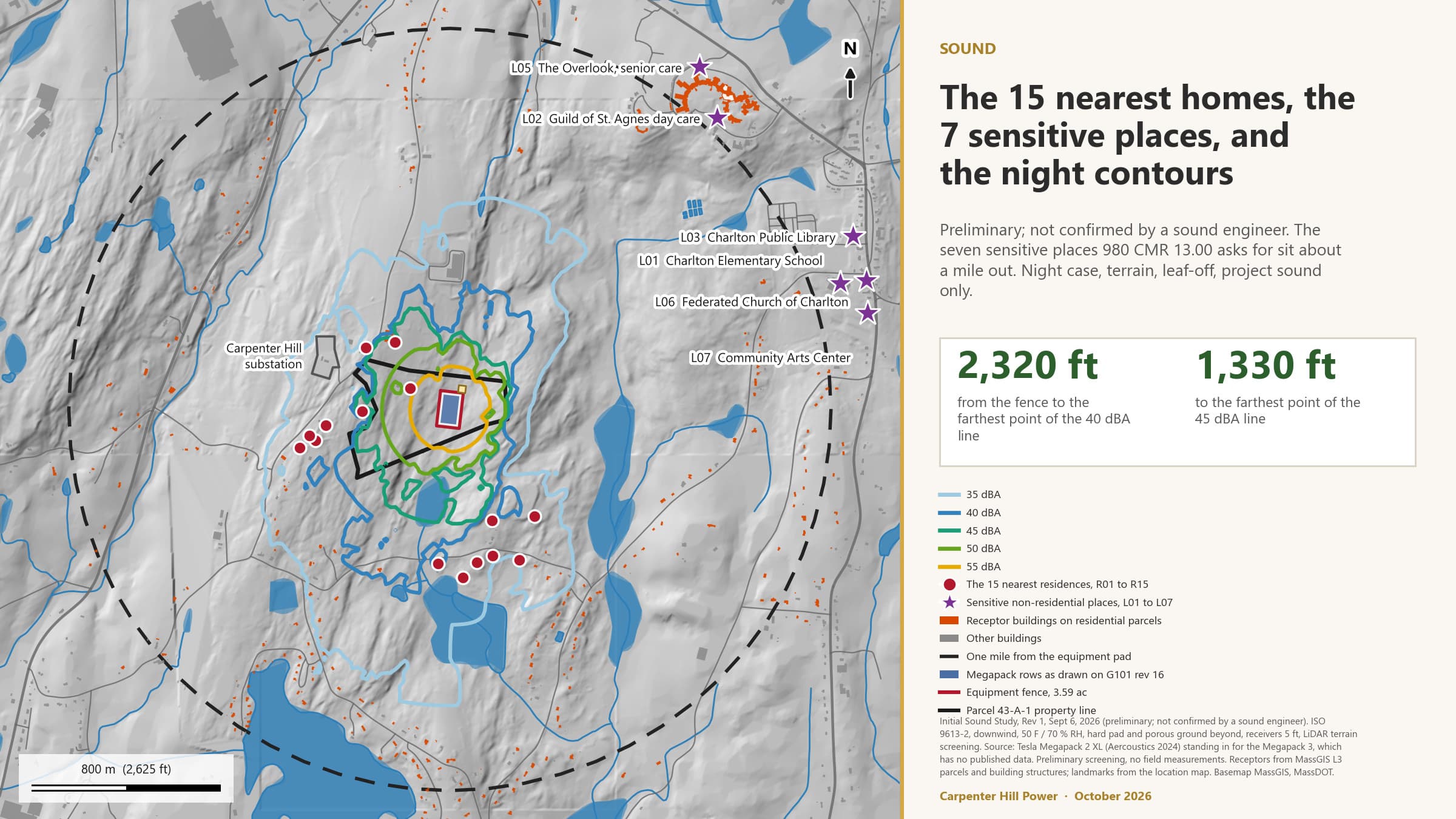
6 · Operations phase: project impacts on the Elevated Indicators · Figure 15
Night typical case: preliminary screening before any fixes
6 · Operations phase: project impacts on the Elevated Indicators · Figure 16
Mitigated equipment plus a 20 ft wall, a test case in the preliminary screening
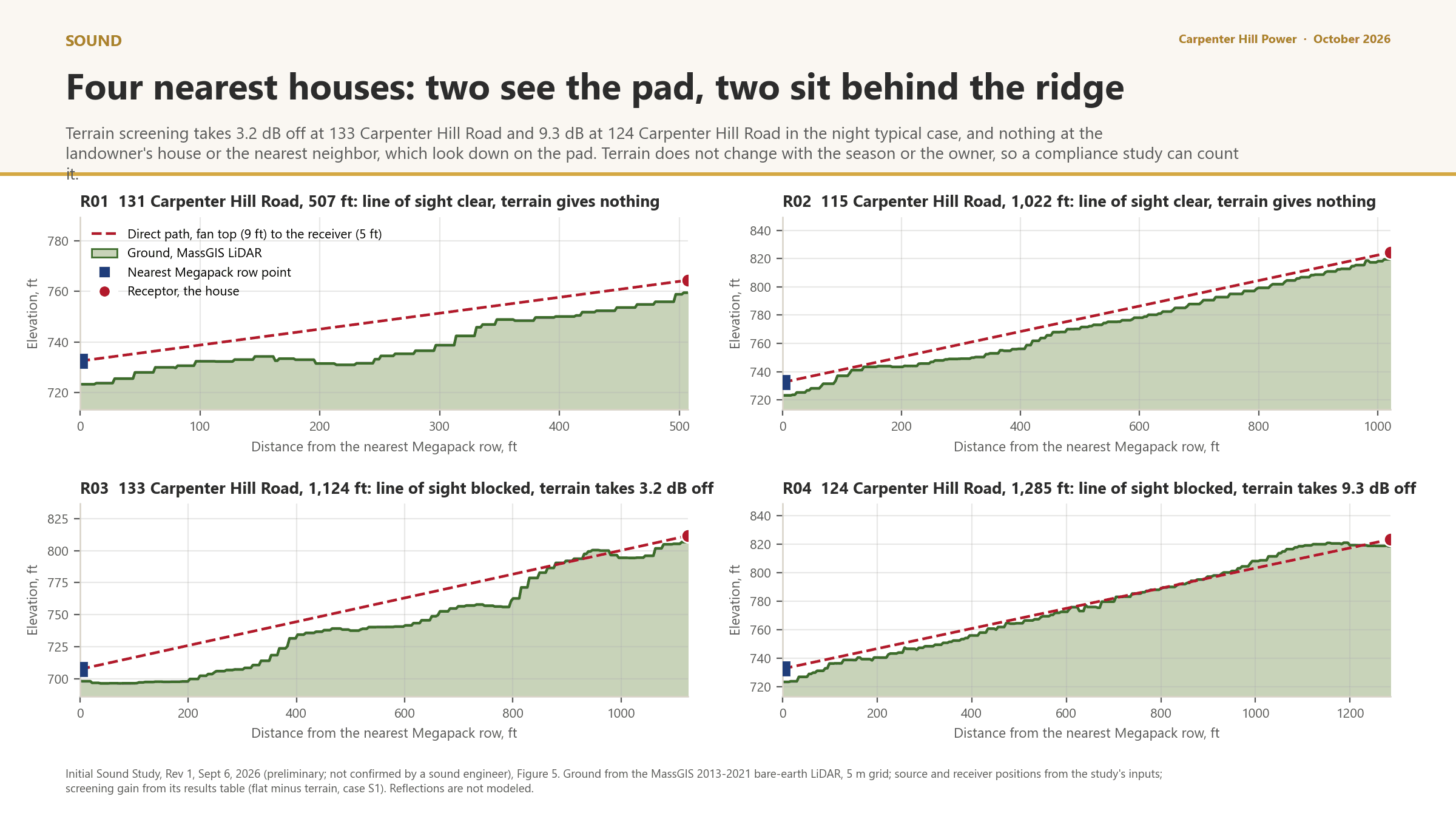
6 · Operations phase: project impacts on the Elevated Indicators · Figure 17
Terrain profiles to the four nearest houses
CIA Report Template Part V; 980 CMR 15.08
Avoidance, minimization and mitigation
980 CMR 15.08 requires Remedial Actions only where a Disproportionate Adverse Effect is found. None is found in this draft. The measures below are listed anyway, in the mitigation hierarchy the guidance sets out, because they are the reason the answers in Sections 5 and 6 are no, and because the Board can make any of them an enforceable condition.
Avoid first: no wetland fill, no work inside mapped rare species habitat, a site in Zone X, no combustion.
Then minimize: clearing held to 10 acres, run-on diverted, containment for every liquid, firewater captured, noise designed to the policy.
Then mitigate: replanting for the acres cleared, a groundwater monitoring program, an Emergency Action Plan with independent review.
Costs are stated in the Application. No figure in this draft.
7 · Avoidance, minimization and mitigation
Measures that avoid, minimize or mitigate the impacts (1 of 2)
| Elevated Indicators addressed | Type | Measure |
|---|---|---|
| Impaired water bodies; groundwater threats; flood risk | Avoidance | No wetland fill; setbacks from wetland resource areas, mapped today and field delineated after the pre-filing engagement period, before the Application; the whole site in FEMA Zone X. |
| Wildfire risk; adult cancer; COPD; PM2.5 | Avoidance | No combustion, no stack, lithium iron phosphate chemistry. |
| Groundwater threats; impaired water bodies | Minimization | Tree clearing outside the transmission right-of-way held at or under 10 acres; the 45.6 acres of run-on diverted around any containment; post-construction runoff held at today's rate; a catchment swale along the southern boundary in the current design. |
| Groundwater threats; pollution cleanup sites | Minimization | Secondary containment sized to 110 percent for transformer oil, an SPCC plan, a Licensed Site Professional before construction, and firefighting water captured on site with testing before disposal. |
| Wildfire risk; premature mortality; pediatric asthma | Minimization | In the current design: units designed to meet and exceed UL 9540A testing, with the unit-specific test report filed with the Application (no report for the Megapack 3 is published yet), NFPA 855 separation, a 26-foot fire lane, 50 feet from equipment to fence, cleared ground to the treeline, and an Emergency Action Plan built with the Charlton Fire Department and independently reviewed at the project's expense. Fire water supply planned with the Fire Chief, built at the project's expense if the department needs it. |
7 · Avoidance, minimization and mitigation
Measures that avoid, minimize or mitigate the impacts (2 of 2)
| Elevated Indicators addressed | Type | Measure |
|---|---|---|
| Adult high blood pressure; coronary heart disease | Minimization | Sound designed to the MassDEP noise policy at the property line and the nearest residence; equipment about 500 feet from the nearest home. |
| Groundwater threats | Mitigation | A groundwater monitoring program set with the Board of Health, with terms in writing before construction; a report after the MassDEP groundwater consultation. |
| Carbon and habitat (not Elevated Indicators; listed for completeness) | Mitigation | Replanting to offset the acres cleared, a proposal in the draft Community Benefits Plan and an expected permit condition; the PH 865 boundary staked by survey as a no-disturbance line, subject to NHESP's confirmation. |
| All | Accountability | Every commitment on a public tracker with what closes it; studies posted as they finish; design changes logged with the reason. |
CIA Report Template Parts VI and VII; 980 CMR 15.02 (Benefit); 15.11(2)(h)
Project benefits and the Community Benefits Plan
The regulation counts a benefit for CIA purposes only if it has a geographic, economic, public health or scientific connection to where the Burdened Area and the SGA overlap. The benefits below meet that test. Anything drawn from the draft Community Benefits Plan is a proposal, still being shaped with the Citizen Advisory Committee and open for public comment through November 30, 2026, and is labelled that way.
Reliability: stored electricity for about 120,000 homes for about four hours, delivered through the substation next door.
Revenue to the town over the operating life, in a form the town and the project decide together.
Construction employment and training, with a local hiring preference proposed in the draft plan.
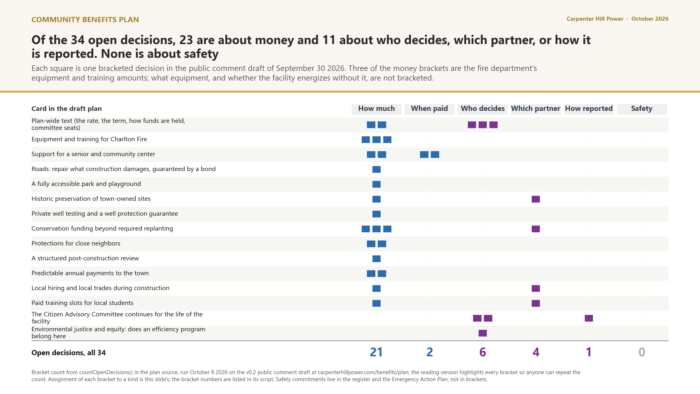
Fire readiness, well protection and conservation are proposals in the draft plan, not commitments, and mitigation is never counted as a benefit.
8 · Project benefits and the Community Benefits Plan · Figure 18
What the 34 open decisions are about
CIA Report Template Part VIII; 980 CMR 15.11
Conclusion, and what would change it
On the record so far, the project is not expected to materially exacerbate any of the 16 Elevated Indicators in block group 250277561012 in construction or in operation, so no Disproportionate Adverse Effect is identified and no Remedial Action is required under 980 CMR 15.08. That conclusion is preliminary, and this section says exactly what it rests on.
No Disproportionate Adverse Effect identified, in either phase, on the current record.
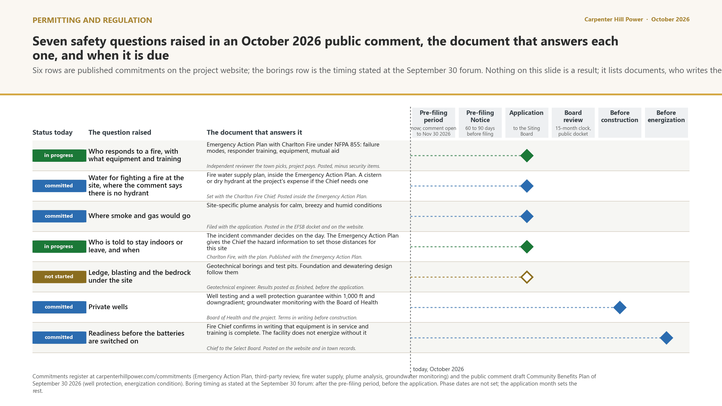
The conclusion rests on three unfinished studies: fire protection engineering, the sound study, and the final stormwater and containment design.
The Board makes its own finding under 980 CMR 15.11 and can add enforceable conditions.
This report is reissued when the studies finish and again with the Application. Every version stays published.
980 CMR 15.07(4) and 15.04(6); OEJE guidance Part VI
Community input, and how to take part
The rule requires the project to gather community input during pre-filing and address it in this report. The guidance says lived experience is data. This section records what residents and officials have raised that bears on the analysis, where the record of it lives, and the two ways a reader can change what this report says.
Wells and waterways, fire, cumulative burden, noise and property values: raised at every public meeting since April.
Every question and answer is on the Engagement Log, and every commitment it produced is on the tracker.
Tell us a fact this report is missing, and we check it and answer on the log.
Ten residents of a block group inside the SGA can ask for a full analysis of a block group that is not a Burdened Area.
10 · Community input, and how to take part · Figure 19
What is not known yet, and when it will be
CIA Report Template Appendix A and B
Sources, methods and terms
The indicator definitions and sources are the state's, from Appendix A of the CIA Report Template and the MassEnviroScreen technical documentation. The method for deciding whether an impact is material is the template's Appendix B, applied row by row in Sections 5 and 6.
Indicator percentiles read from the state's February 27, 2026 MassEnviroScreen build on September 8, 2026.
Materiality judged on the template's Appendix B factors: standards, perceptibility, measurability, duration, extent, resilience, social and health effects, migration.
What happens next
Questions, corrections and what comes next
No Disproportionate Adverse Effect identified, in either phase, on the current record.
The conclusion rests on three unfinished studies: fire protection engineering, the sound study, and the final stormwater and containment design.
The Board makes its own finding under 980 CMR 15.11 and can add enforceable conditions.
This report is reissued when the studies finish and again with the Application. Every version stays published.
Questions about this report?
Jonathan Santiago
Project Development Associate, ESA Solar
These slides stay online atcarpenterhillpower.com/reports/cumulative-impact