Site Suitability Analysis · Preliminary draft v0.4
Site Suitability Analysis
980 CMR 15.10 · October 12, 2026
Follow along at carpenterhillpower.com/reports/site-suitability
Before we start
What this report found
Five of the six state criteria carry a provisional score: burdens 4.0, carbon 3.7, biodiversity 2.9, agriculture 0.0, and no overlap with protected open space. Climate change resilience is not scored by the tool for an inland site.
The July 17, 2026 run scored a 5.7-acre pad footprint. The Facility Boundary the rule defines is 17.29 acres, so the tool is being re-run before the Pre-filing Notice.
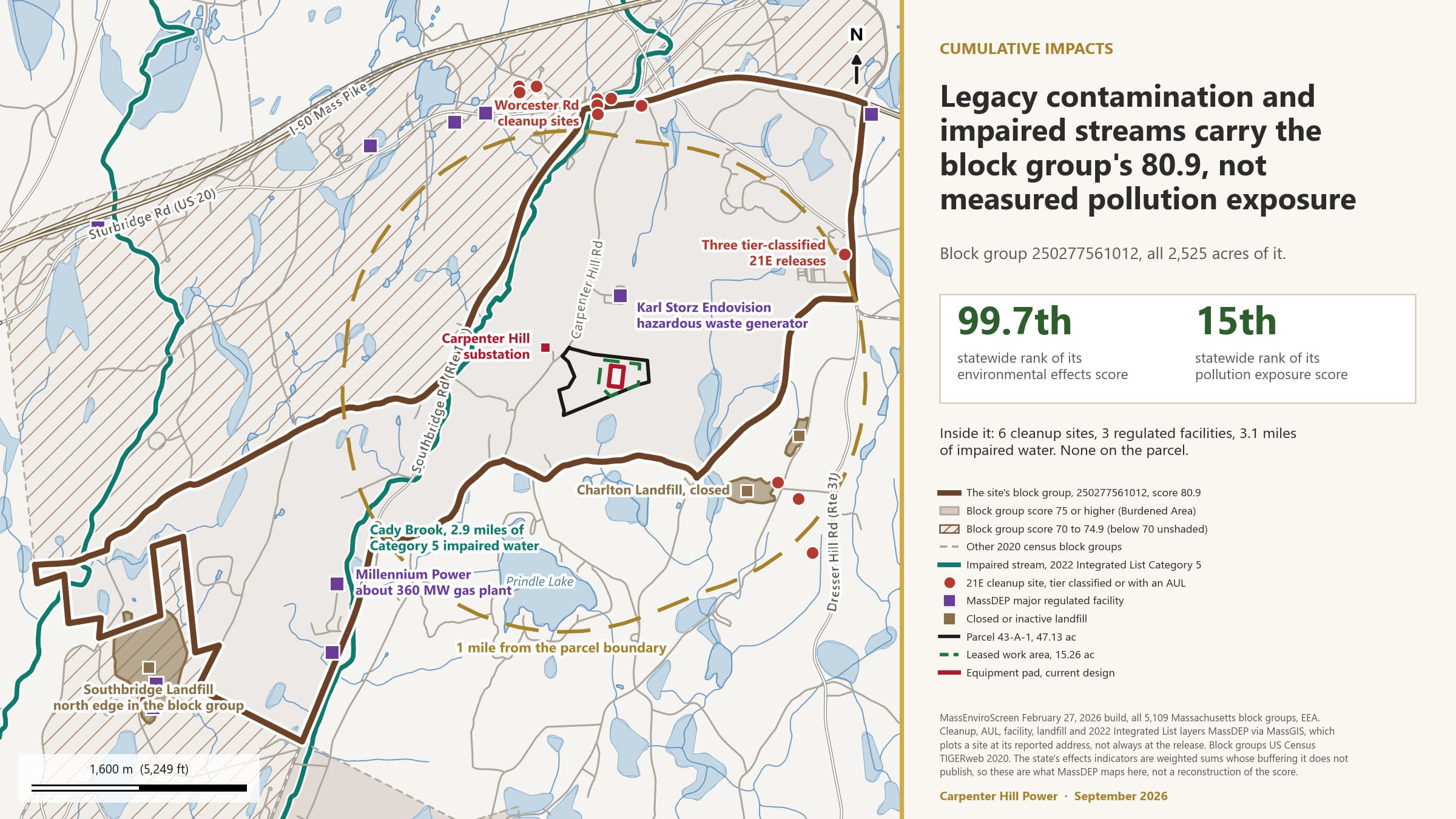
The one score design cannot move is the 4.0 for burdens, set by the block group's MassEnviroScreen score of 80.9.
Beyond the criteria, the desktop screening found poorly drained soil under the pad, drainage south toward a small wetland, a 0.05-acre overlap with the wetland buffer zone, 0.11 acre of the pad above a draft slope limit, and two private wells about 0.4 mile downhill in the same drainage. Each is a desktop finding on published mapping, and each is assigned to a study.
The full report is at carpenterhillpower.com/reports/site-suitability; every slide here is derived from it.
Contents
What is in this report
1 · Summary
2 · What the rule requires
3 · The site and the Facility Boundary
4 · Anticipated scores
5 · Each criterion, and what sits behind it
6 · Beyond the six criteria: what the site screening found
7 · How the criteria shaped the site and the design
8 · What happens next
9 · Sources, methods and terms
What this report is and what it found
Summary
The state scores every proposed clean energy site on six criteria before the Siting Board decides on it. This report gives the anticipated scores for the Carpenter Hill site, explains what sits behind each one, adds what the site screening found beyond the six criteria, and records how all of it has shaped the design so far.
Five of six criteria carry a provisional score from the July 17, 2026 run of the state's Site Suitability Mapping Tool.
That run scored a 5.7-acre pad footprint. The Facility Boundary the rule defines is 17.29 acres, so the tool is being re-run before the Pre-filing Notice.
The one score that cannot change with design is the 4.0 for social and environmental burdens. It comes from the block group, not the site.
No automatic 5.0 applies: the boundary overlaps no protected open space, no wetland is filled, and no rare species habitat is inside it.
Six site findings from the September 2026 screening are each matched to the study that answers them.
980 CMR 15.10 and the Site Suitability Guidance
What the rule requires
980 CMR 15.10 is short. It tells the project which guidance to follow, when to run the tool, when the scores become final, who can ask for them to be revised, and how the Board uses them. This section walks through it so a reader can check the rest of the report against the rule.
Applies to large and small clean energy storage facilities, so it applies here.
Run the state tool before filing and share the anticipated scores during pre-filing.
File the Site Suitability Report with the Application. Scores are then final unless revised or modified.
Any Key Stakeholder can ask the Director for a score revision within 30 days of a request.
The burdens score can be modified only by mutual written agreement with the town.
980 CMR 15.02, definition of Facility Boundary
The site and the Facility Boundary
Every score depends on what area the tool is asked to score. The regulation names that area the Facility Boundary. This section measures it from the current site plan, shows the three pieces that make it up, and records the two places the drawing and its title block disagree.
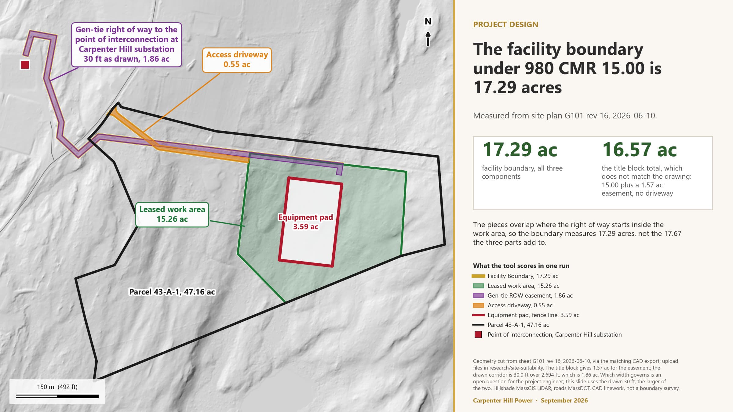
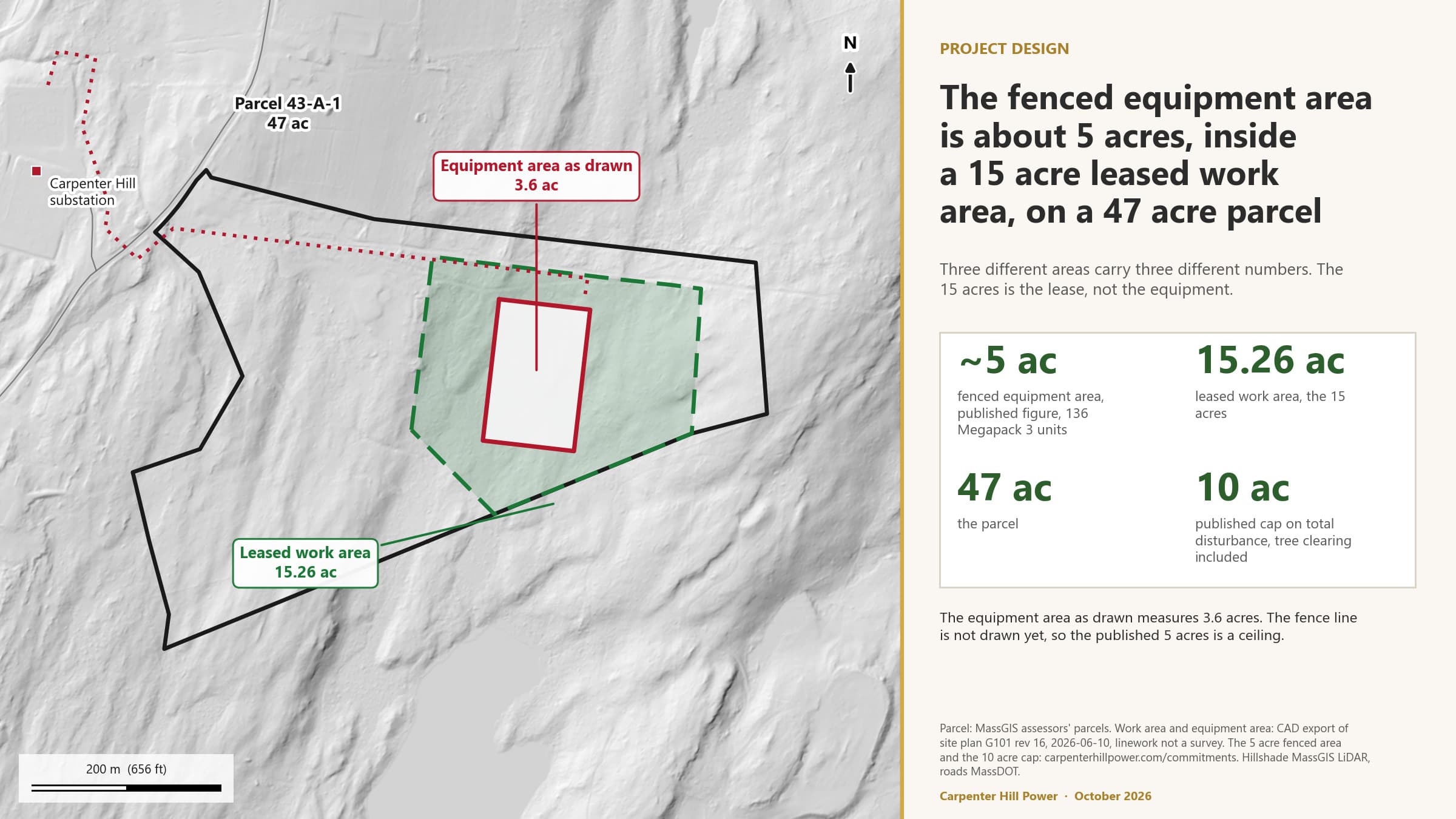
Parcel 43-A-1 at 131 Carpenter Hill Road is 47.13 acres by the assessor and 47.16 acres as drawn.
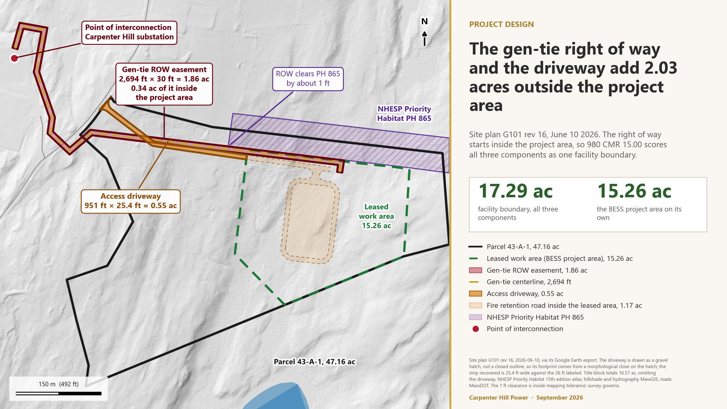
The Facility Boundary is 17.29 acres: the BESS project area, the gen-tie easement and the access driveway, merged into one polygon.
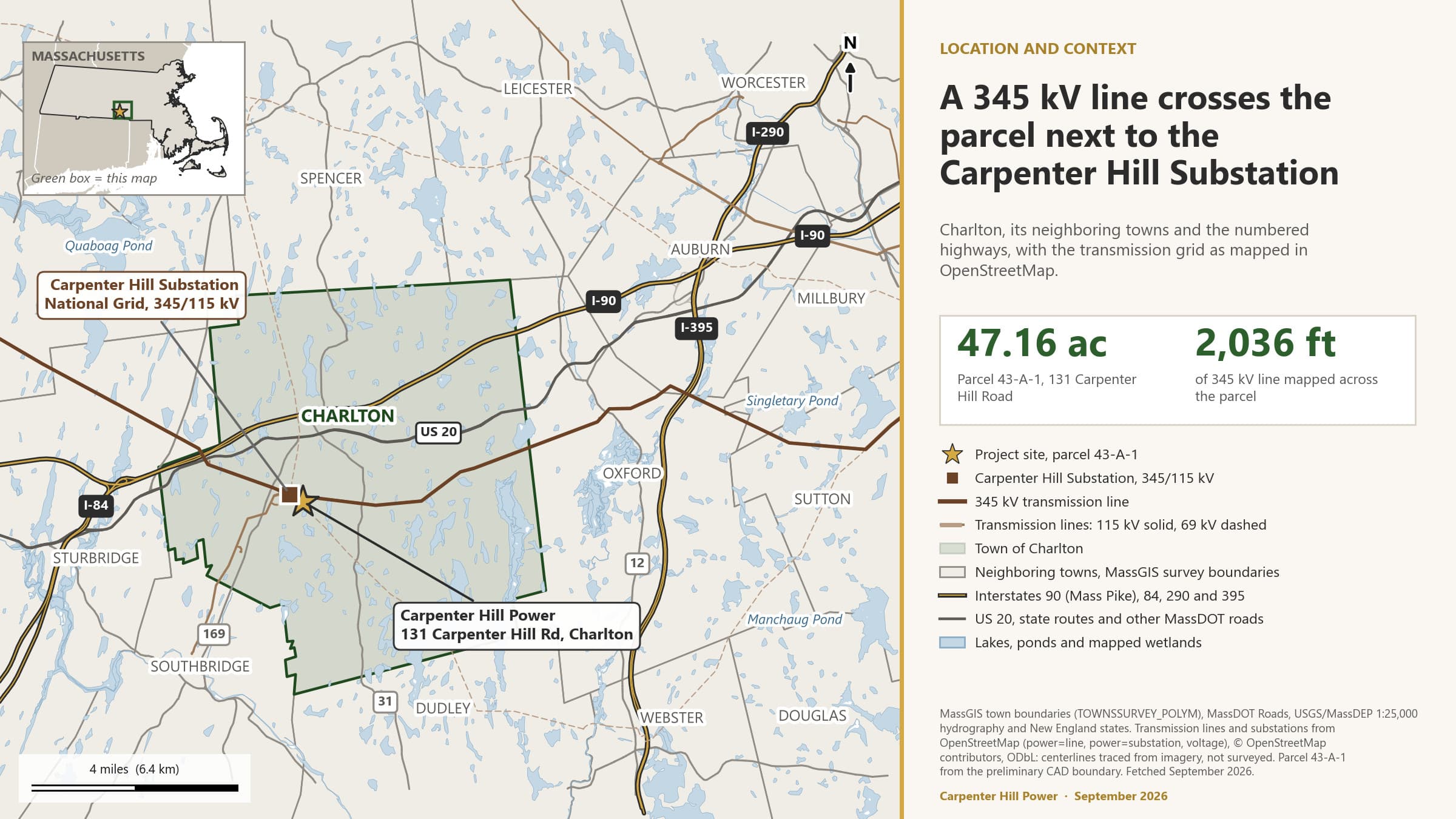
About 1,142 feet of the gen-tie easement runs outside the parcel, to the Carpenter Hill substation.
The July 17 run scored 5.7 acres, the pad footprint at the time, which is why every score is provisional.
3 · The site and the Facility Boundary · Figure 1
The facility boundary for the state suitability tool
3 · The site and the Facility Boundary · Figure 2
Gen-tie right of way and driveway extents
3 · The site and the Facility Boundary · Figure 3
Parcel, leased work area and equipment area
3 · The site and the Facility Boundary · Figure 4
Regional locus
980 CMR 15.10(2), July 17, 2026 tool run
Anticipated scores
These are the numbers the state tool produced for a 5.7-acre site area on July 17, 2026, with the statistics the tool prints beside each one. They are the anticipated scores 980 CMR 15.10(2) asks the project to share. None is final.
Social and environmental burdens 4.0, carbon 3.7, biodiversity 2.9, agricultural resources 0.0.
Climate change resilience 0.0, from the Climate Resilience Design Standards Tool, and protected open space returned no overlap.
No development-potential modifier applies: the site is not a brownfield, a landfill or previously developed land.
The re-run on the 17.29-acre boundary is expected to move carbon and biodiversity and to be checked for agriculture.
4 · Anticipated scores
The scores, criterion by criterion
Social and environmental burdens
Band lookup from the host block group's MassEnviroScreen score of 80.9, which falls in the above-70-to-90 band. The tool takes the highest score of any overlapping block group; only one block group overlaps. This score does not move with the boundary or the design.
4.0
Carbon sequestration and storage
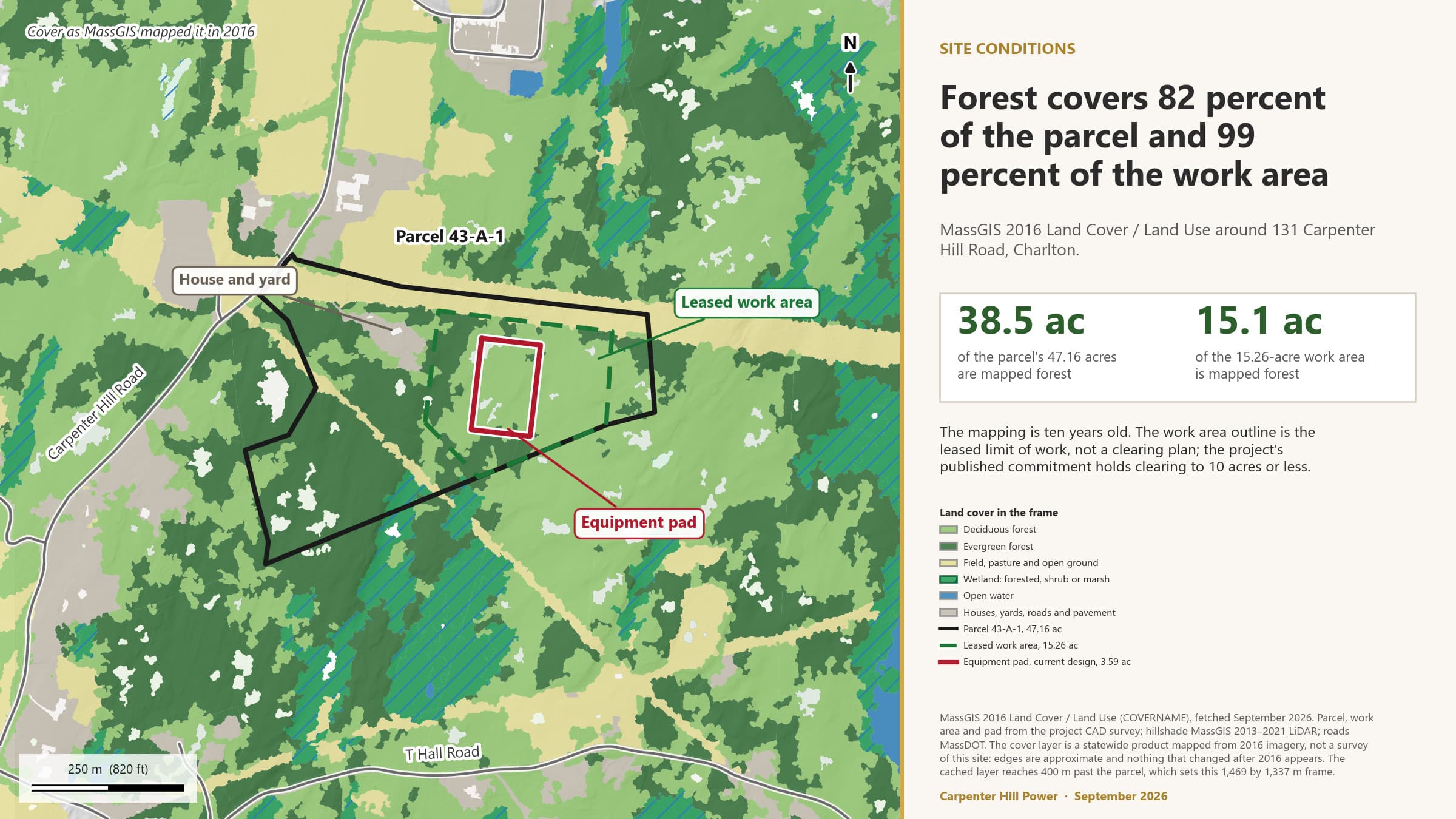
Mean of all Ecosystem Carbon Index values across 25 grid cells. The tool also reports a 25th percentile of 3.5 and a median of 3.9. Expected to move on the re-run: the corrected boundary adds about 11.6 acres, most of it forest.
3.7
Biodiversity
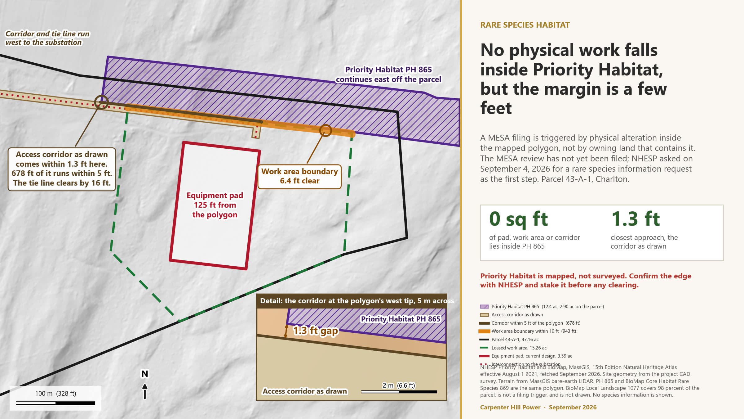
Mean of the top quarter of Biodiversity Index values across 25 cells. The mean of all cells is 2.6 and the median 2.5. Expected to move for the same reason. Mapped rare species habitat comes within about a foot of the corrected boundary without overlapping it.
2.9
Agricultural resources
Mean of the top half of Agricultural Resource Index values. Every cell in the 5.7-acre area scored zero. The corrected boundary clips about 0.009 acre of prime farmland soil unit 305B where the gen-tie easement meets the road, so this one is re-run rather than assumed.
0.0
Climate change resilience
The mapping tool does not produce this criterion, so its report carries no climate page. The guidance scores it from the state's Climate Resilience Design Standards Tool, taking the higher exposure rating for riverine flooding and for coastal flooding from sea level rise and storm surge. The September 4, 2026 run returns Not Exposed for both, which scores 0.0. Charlton sits about 35 miles inland, and FEMA places the whole site in Zone X, minimal flood hazard. The inland hazards the criterion does not count, extreme precipitation and extreme heat, are documented in Section 5.
0.0
Protected open space
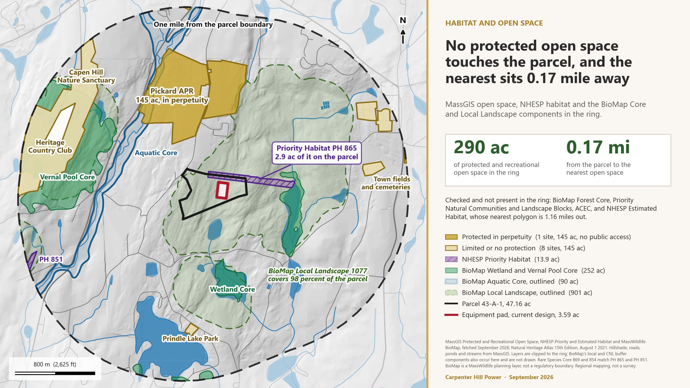
The tool reports that the site does not appear to overlap Protected Open Space. Measured on the corrected boundary, the nearest protected open space is 373 feet away. No automatic 5.0 applies on any criterion.
Scale runs 0.0 (most suitable) to 5.0 (least suitable); climate change resilience runs to 3.0. Sources: Clean Energy Infrastructure Site Suitability Report, official Site Suitability Mapping Tool, July 17, 2026 run, 5.7-acre site area; Climate Resilience Design Standards Tool, version 1.5, Project 55250, run September 4, 2026; FEMA FIRM panel 25027C0788F, effective June 21, 2023.
Site Suitability Guidance criteria, read against the September 2026 site screening
Each criterion, and what sits behind it
A score is a number. This section says what is on the ground behind each one, using the state's own published layers pulled in September 2026, so a reader can see why the site scores as it does and what the re-run is likely to change.
Burdens: legacy contamination and impaired streams carry the block group's 80.9, not measured pollution exposure.
Carbon: forest covers 82 percent of the parcel and 99 percent of the leased work area.
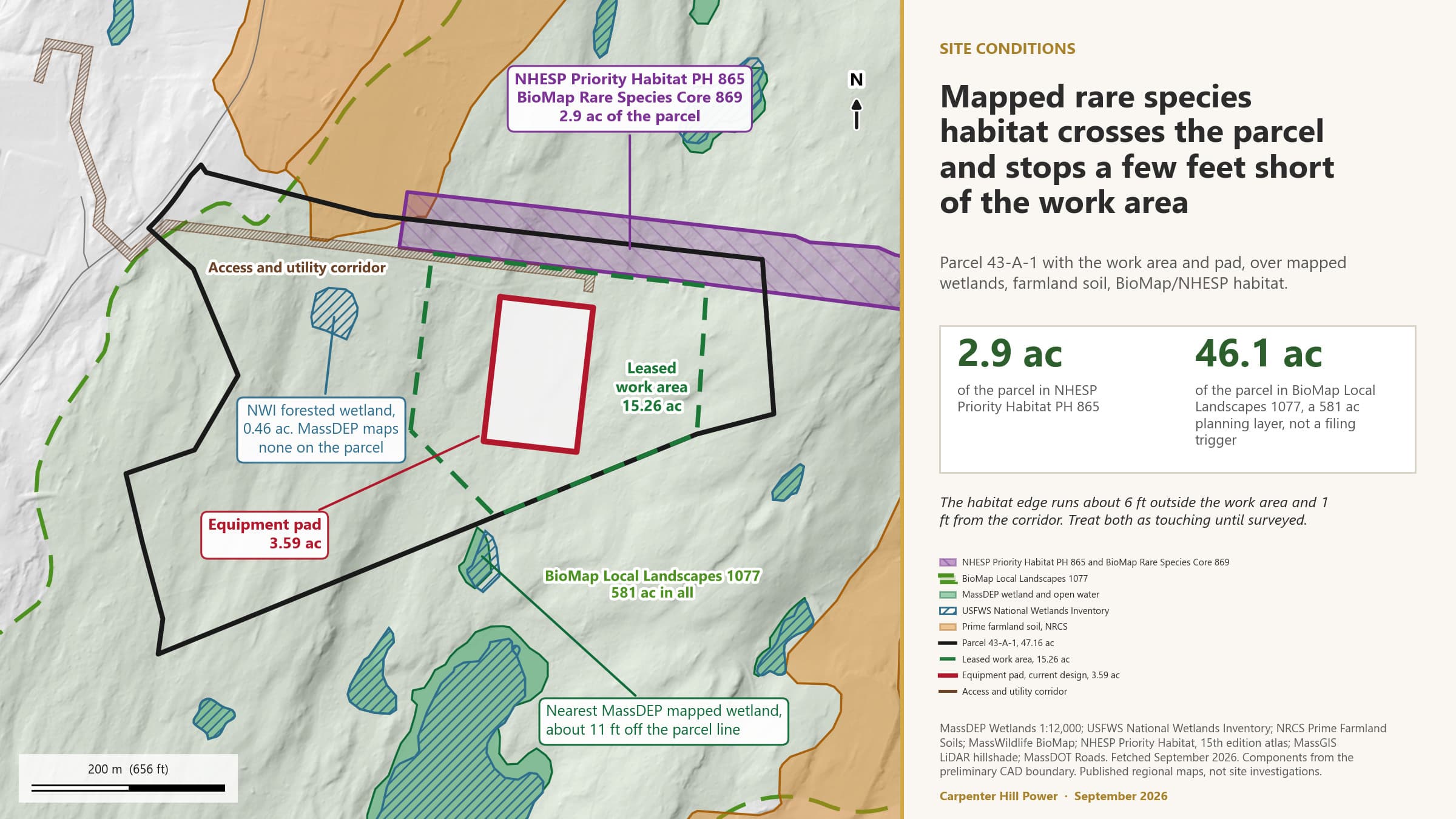
Biodiversity: Priority Habitat PH 865 touches the parcel's northwest edge and stops about a foot short of the boundary.
Agriculture: 0.56 acre of prime farmland soil on the parcel, none in the work area, 0.009 acre clipped by the easement at the road.
Climate: 0.0 of 3, no riverine or coastal flood exposure; high exposure to extreme precipitation and extreme heat by 2070.
Open space: none on or abutting the parcel; the nearest is a private farmland restriction 0.17 mile away.
5 · Each criterion, and what sits behind it
Climate change resilience: 0.0 of 3
The mapping tool leaves this criterion blank. The guidance scores it from the state's Climate Resilience Design Standards Tool, which rates riverine and coastal flooding. Both return Not Exposed here. The same tool gives real numbers for the two hazards that do apply inland.
Riverine and coastal flooding: Not Exposed on both, which scores 0.0. Charlton is about 35 miles inland. FEMA FIRM panel 25027C0788F places the whole site in Zone X.
Extreme precipitation: High exposure. A 10.7-inch, 24-hour rainfall for the 100-year storm by 2070. The MEPA Office asked on September 4 that stormwater be designed to that storm or the departure documented.
Extreme heat: High exposure. Up to 59 days a year above 90 degrees Fahrenheit by 2070, an input to the equipment thermal specification.
Climate Resilience Design Standards Tool, version 1.5, Project 55250, run September 4, 2026.
5 · Each criterion, and what sits behind it · Figure 5
The site's block group, its MassEnviroScreen score and what drives it
5 · Each criterion, and what sits behind it · Figure 6
What is on the ground today
5 · Each criterion, and what sits behind it · Figure 7
Rare species habitat and the work area
5 · Each criterion, and what sits behind it · Figure 8
Environmental resources on and near the parcel
5 · Each criterion, and what sits behind it · Figure 9
Protected open space and mapped habitat within a mile
980 CMR 15.01(3), the Board's consideration of the full range of impacts
Beyond the six criteria: what the site screening found
The regulation says the six criteria do not limit what the Board looks at. The September 2026 screening on LiDAR terrain, published soils and the state layers turned up six findings that matter more to this site than any single score. Each is a desktop finding on published mapping, not survey, and each is paired with the study that answers it.
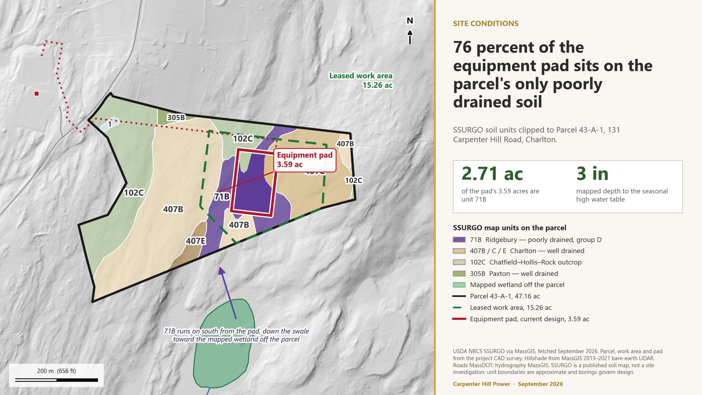
76 percent of the equipment pad sits on Ridgebury soil, the parcel's only poorly drained unit.
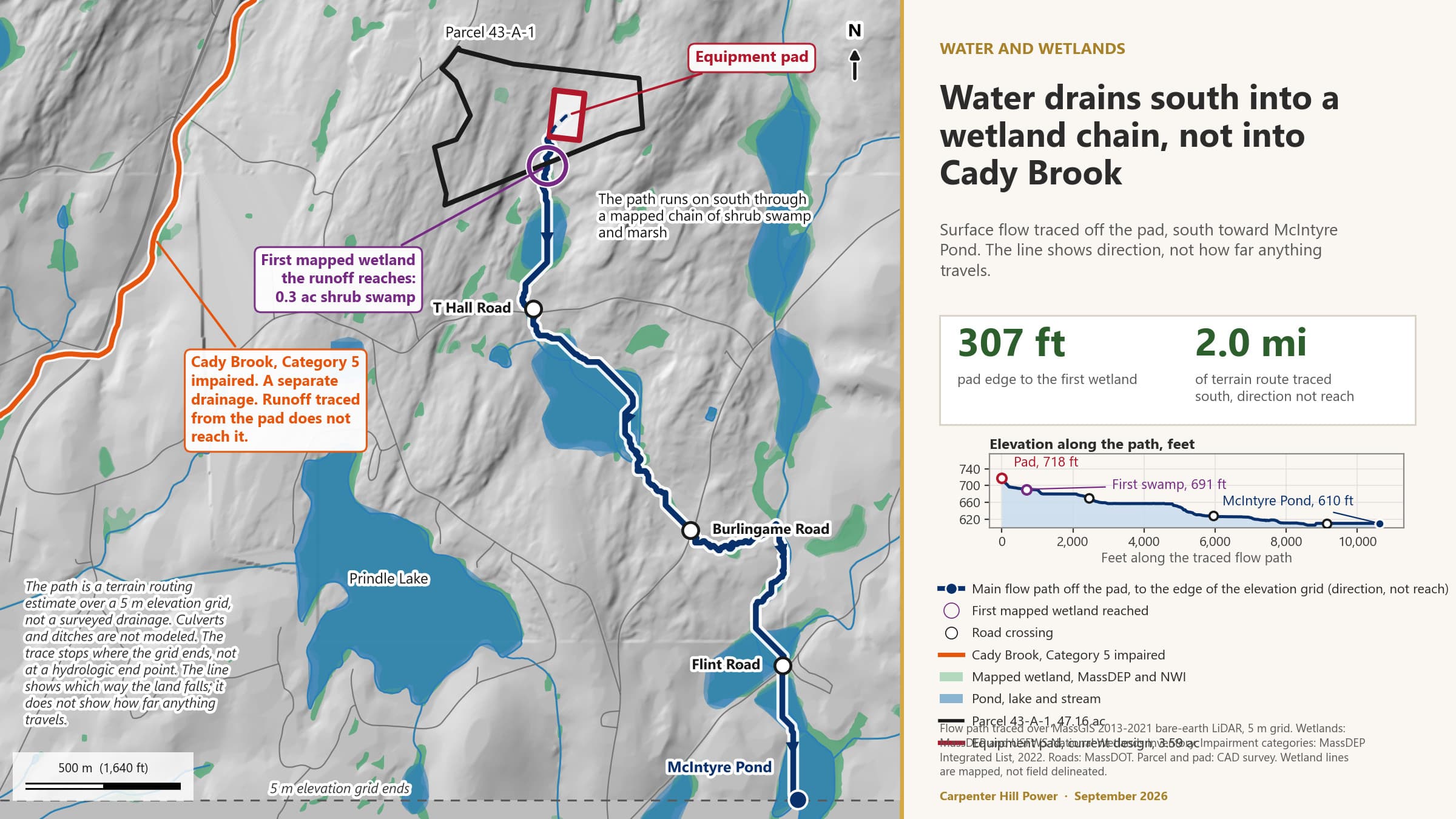
Runoff from the pad goes south to a shrub swamp about 300 feet away, not toward Cady Brook, and 45.6 acres of hillside drain onto the pad from above.
The 100-foot wetland buffer zone reaches about 0.05 acre into the work area at its southern corner, the only place a mapped constraint and proposed work overlap.
About 0.11 acre of the pad sits at or above the 27 percent slope limit in the Board's draft baseline standards.
Of 87 recorded wells within about a mile, two sit downgradient of the pad in its own drainage, and 16 records cannot be placed.
No recorded historic property lies on the parcel or in the work area.
6 · Beyond the six criteria: what the site screening found · Figure 10
Site soils and the equipment pad
6 · Beyond the six criteria: what the site screening found · Figure 11
Where water leaving the pad goes
6 · Beyond the six criteria: what the site screening found · Figure 12
The catchment draining onto the pad
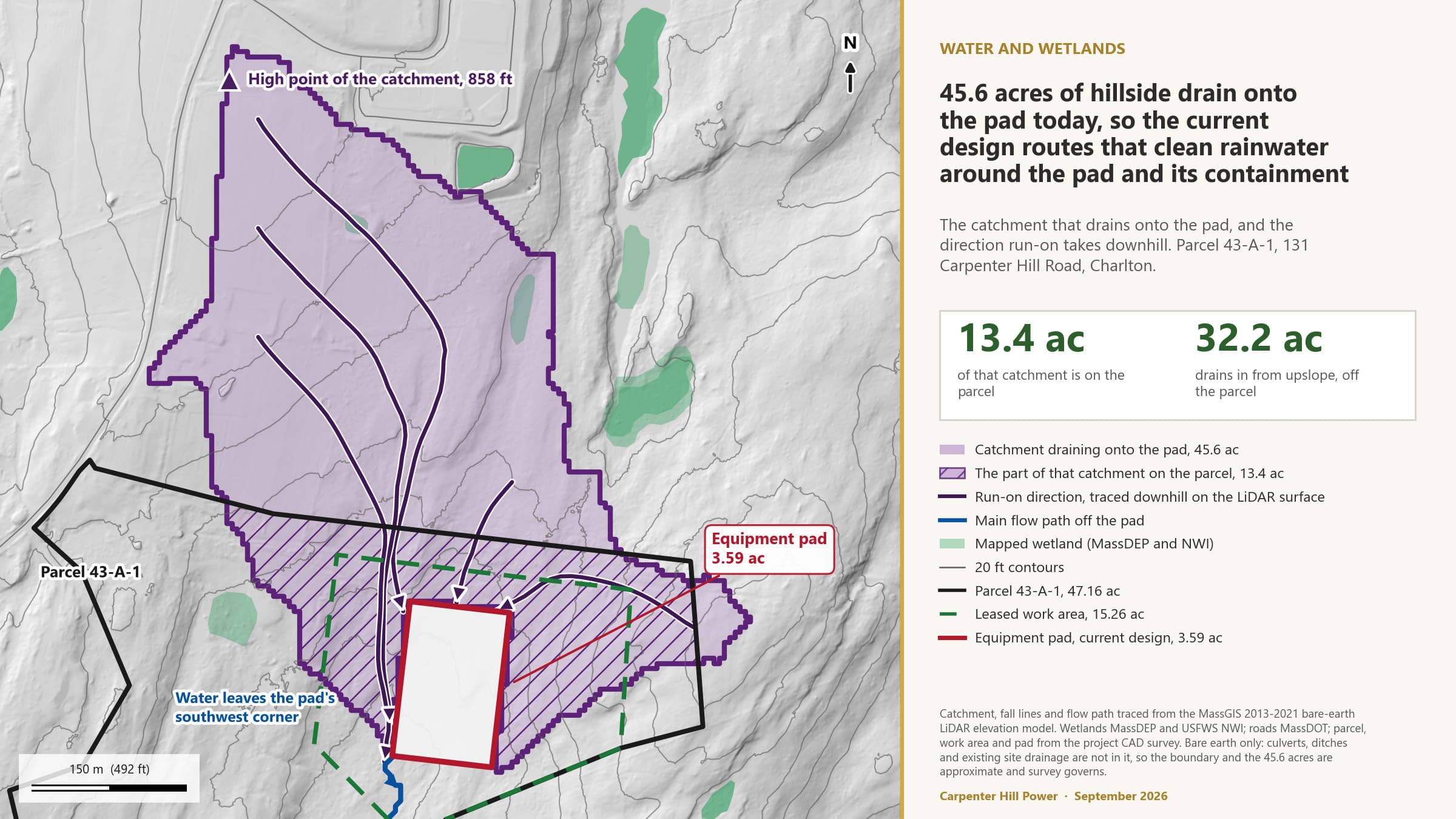
6 · Beyond the six criteria: what the site screening found · Figure 13
How the land within a mile drains, and where the project sits in it
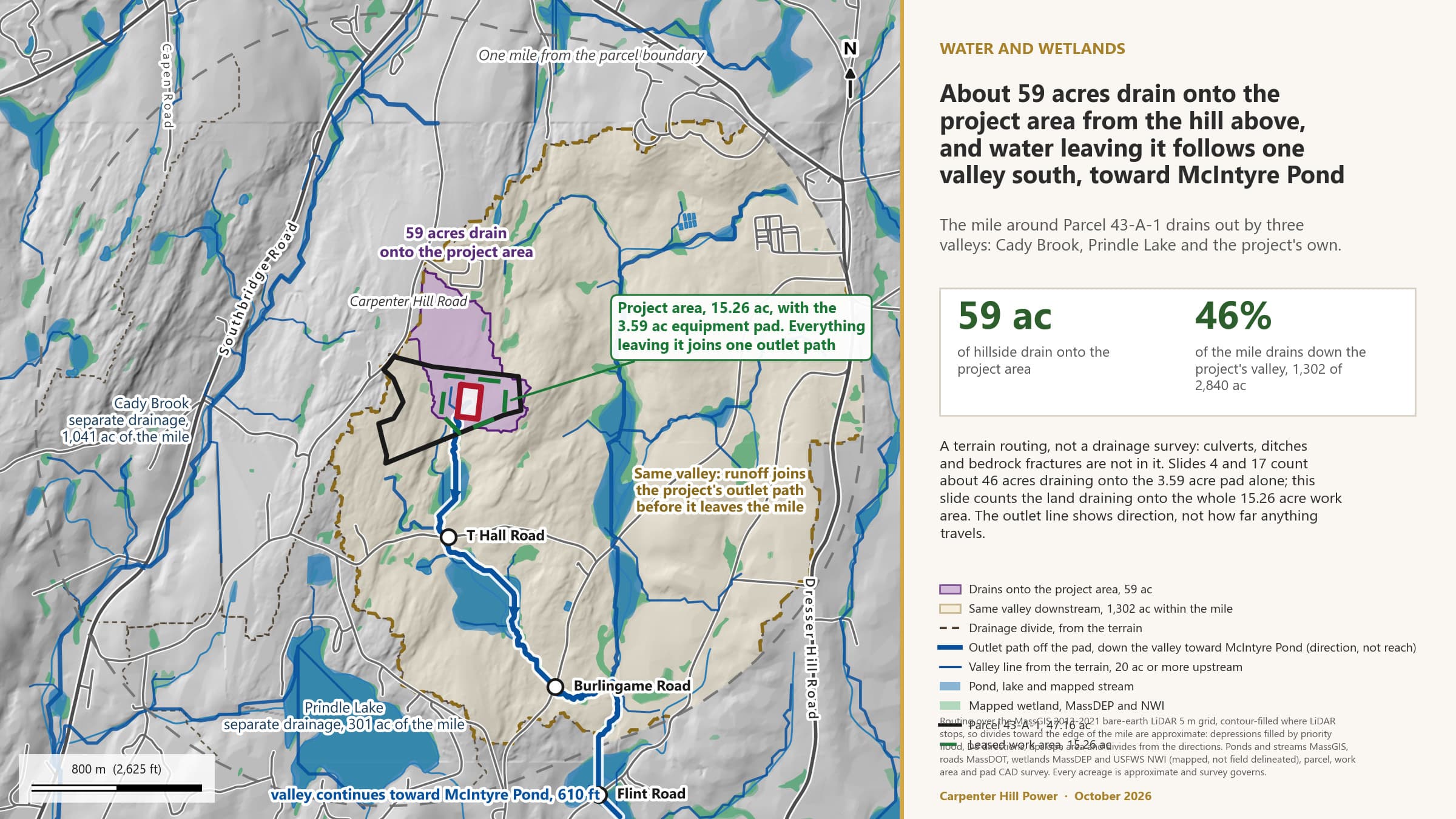
6 · Beyond the six criteria: what the site screening found · Figure 14
Wetlands, buffer zones and the work area
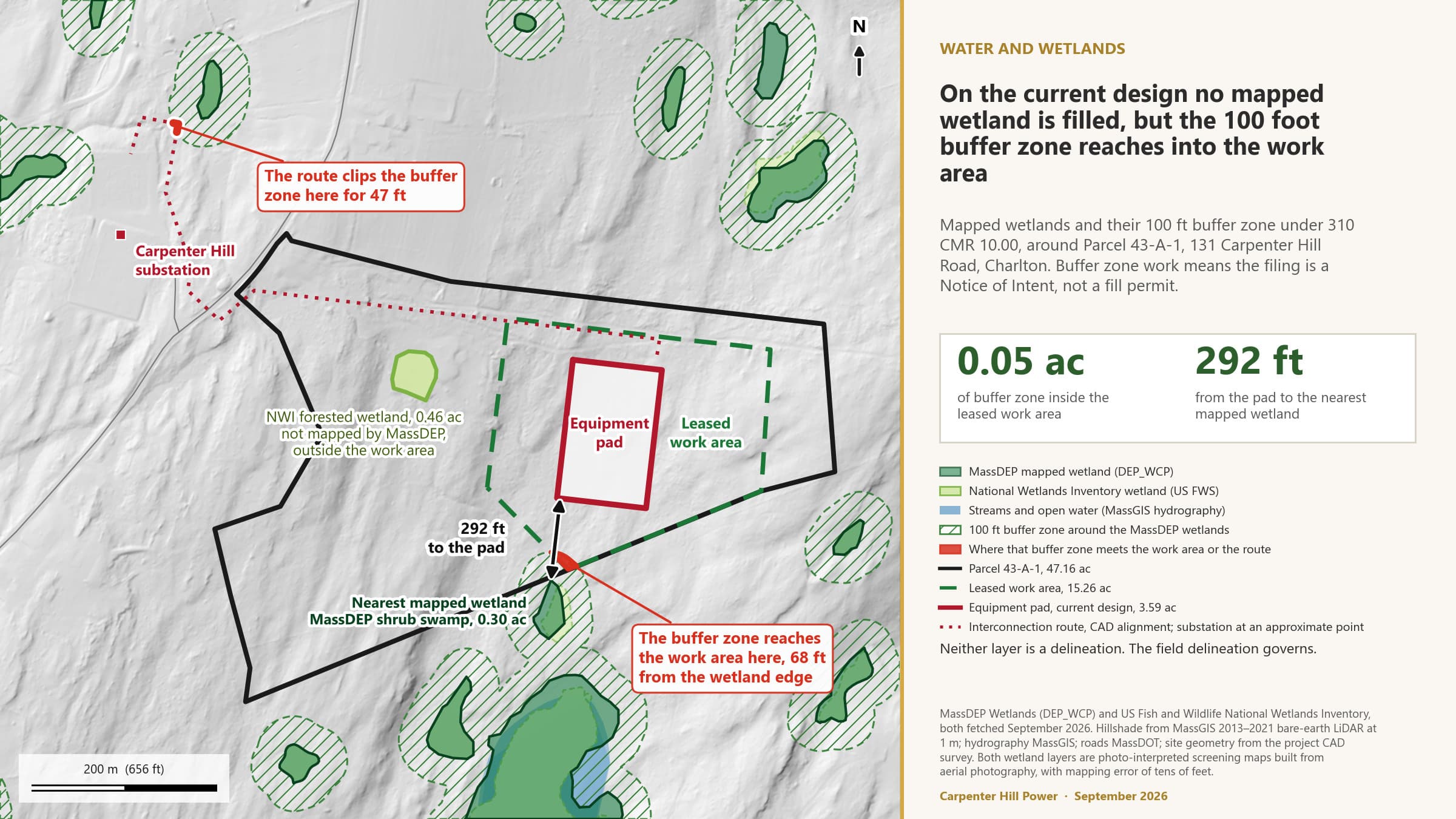
6 · Beyond the six criteria: what the site screening found · Figure 15
Slope against the draft 27 percent siting standard
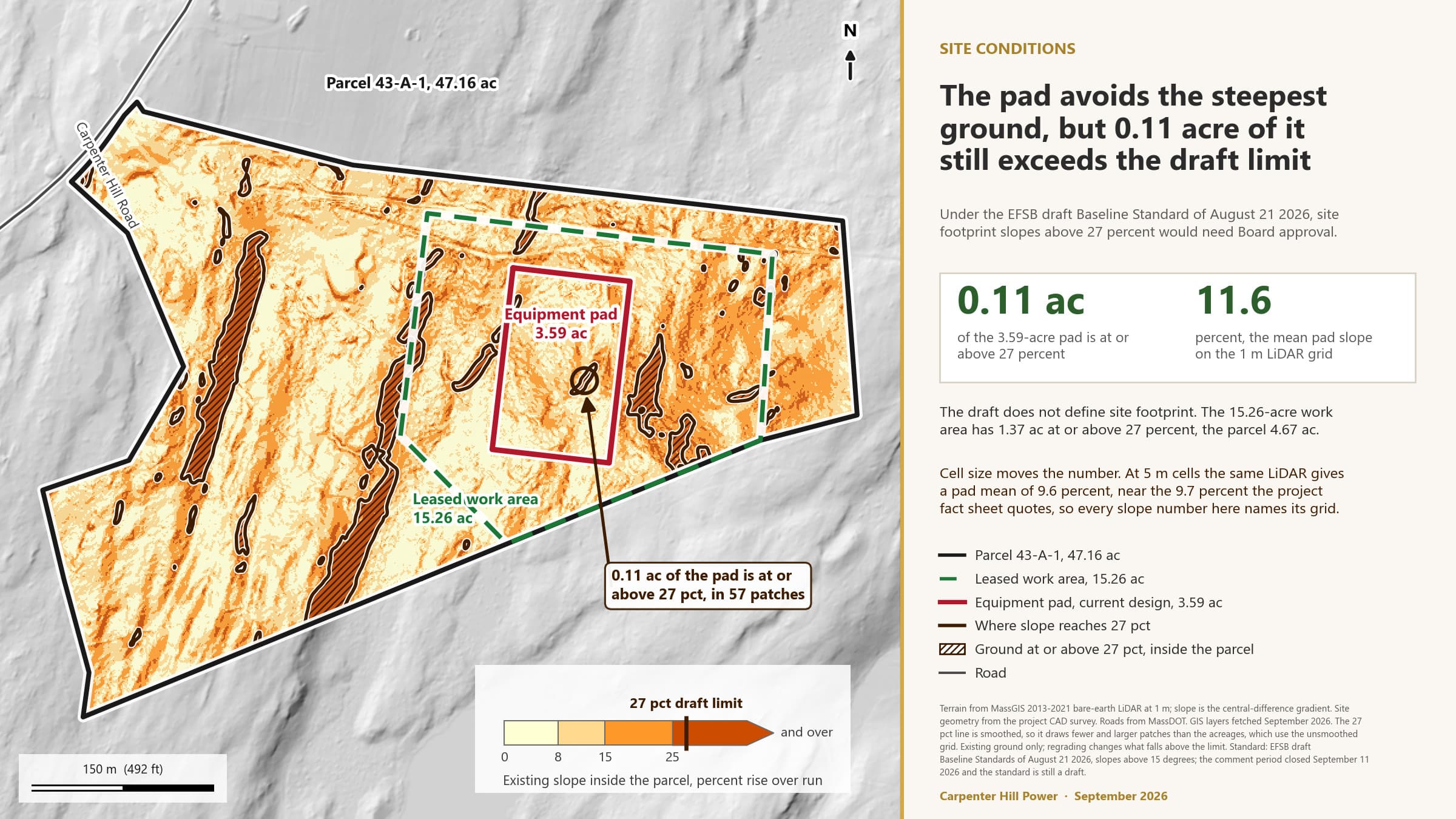
6 · Beyond the six criteria: what the site screening found · Figure 16
Recorded wells: depth to bedrock
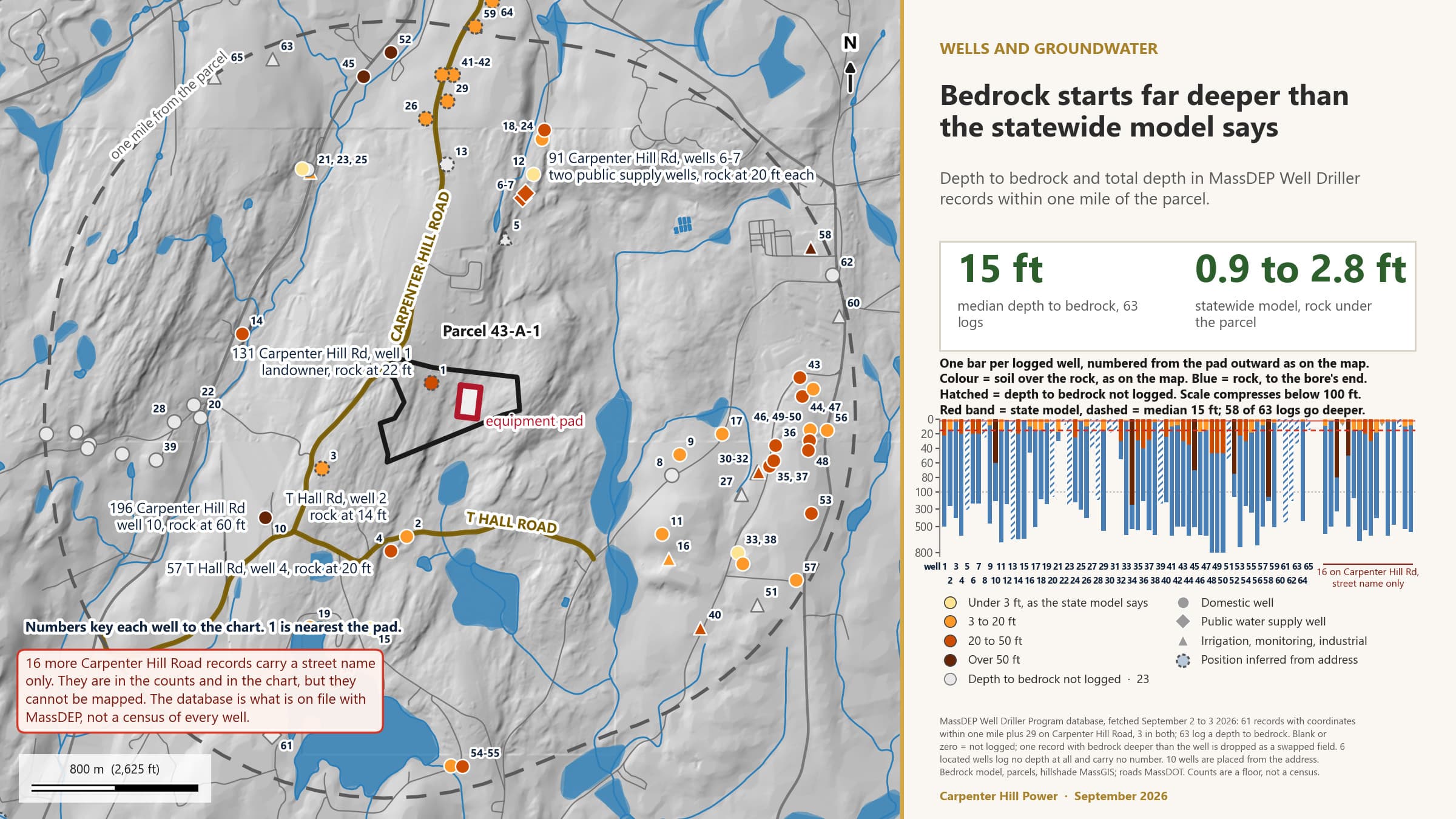
6 · Beyond the six criteria: what the site screening found · Figure 17
Recorded wells: total depth against the pad's ground level
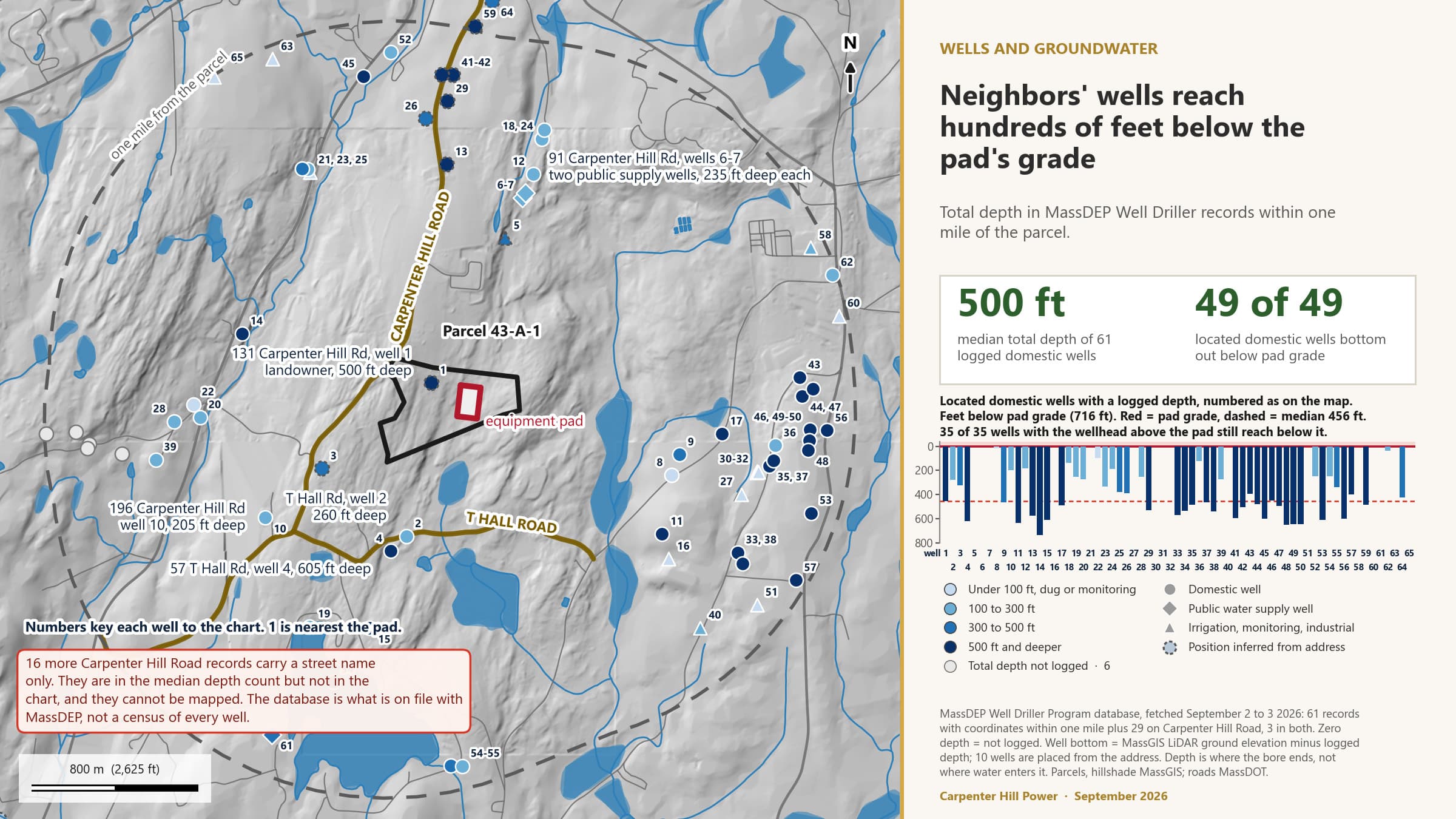
6 · Beyond the six criteria: what the site screening found · Figure 18
Where the water goes and where the wells are
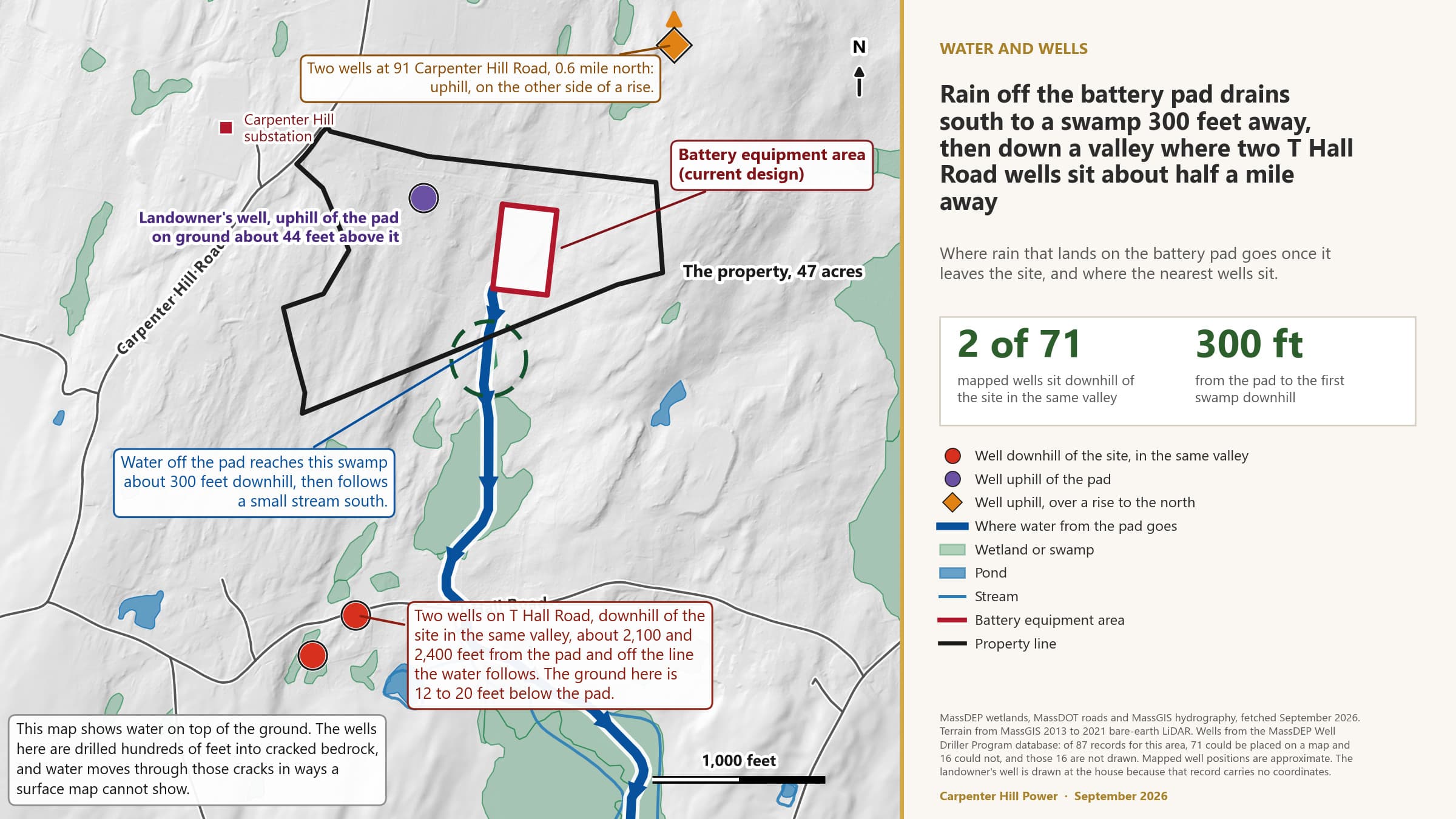
6 · Beyond the six criteria: what the site screening found · Figure 19
What triggers which permit, drawn on the site
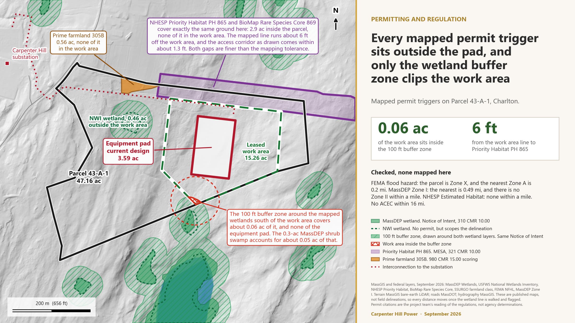
6 · Beyond the six criteria: what the site screening found · Figure 20
Mapped historic and cultural resources
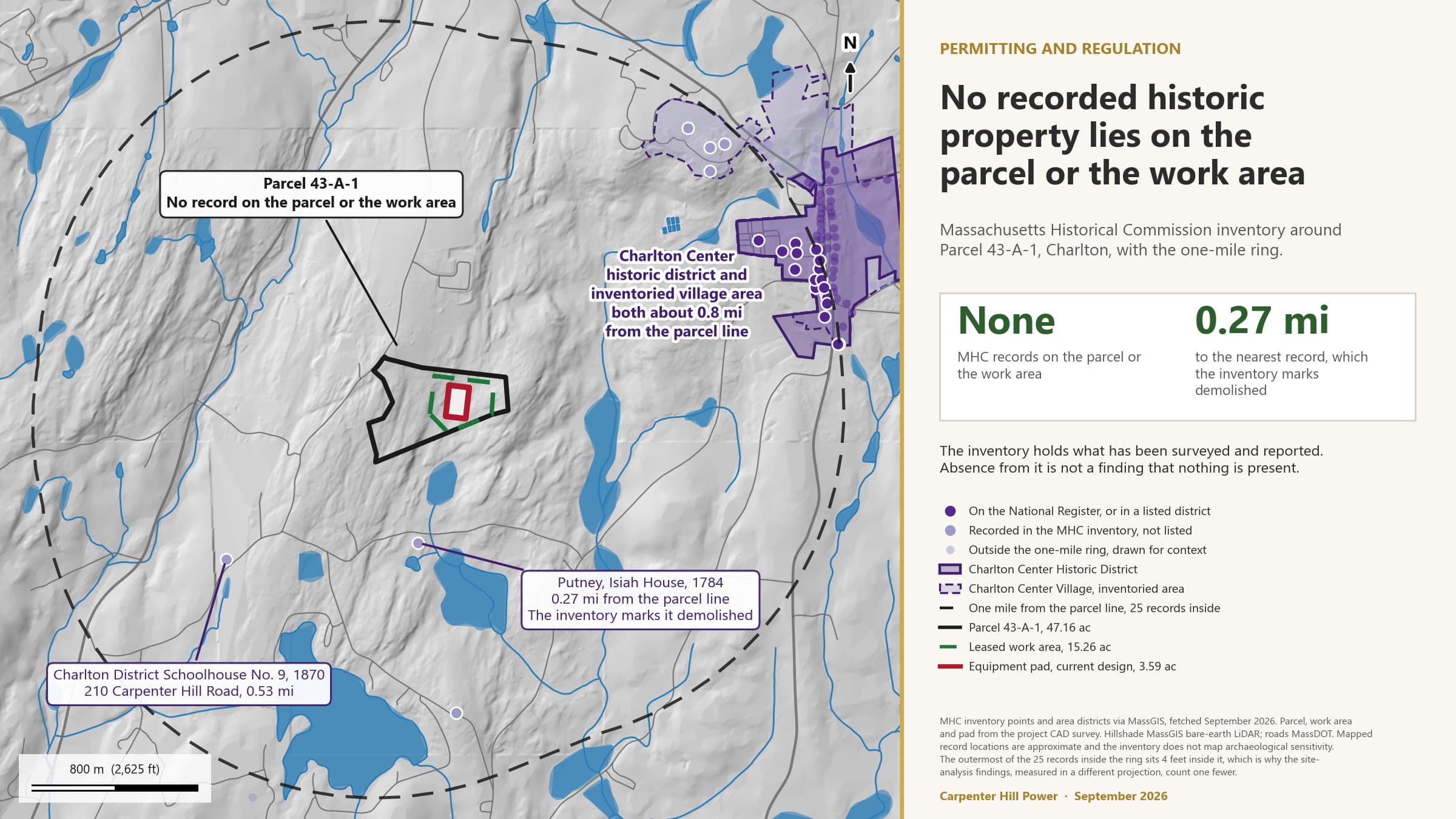
980 CMR 16.09(1)(a)4 and 16.04(1)(d)2
How the criteria shaped the site and the design
The siting rules ask the project to say how the site suitability criteria have been incorporated into choosing the site and shaping the design. The honest answer is in three parts: why this parcel, what the screening changed, and what is still open.
The site was chosen for the substation next door, so the facility connects through a 2,694-foot gen-tie instead of new long-distance transmission.
The 10-acre clearing cap dates from the first Citizen Advisory Committee meeting in June 2026. The screening made the habitat boundary a no-disturbance line. The move from 156 to 136 units came from newer equipment, not from the screening.
Six September 2026 findings are each assigned to a study. Through pre-filing the work is desktop analysis plus a door-to-door well survey; field investigation follows, before the Application.
A parcel-wide search for a better pad location is complete as a desktop study and is under engineering review.
7 · How the criteria shaped the site and the design · Figure 21
The transmission grid around the site
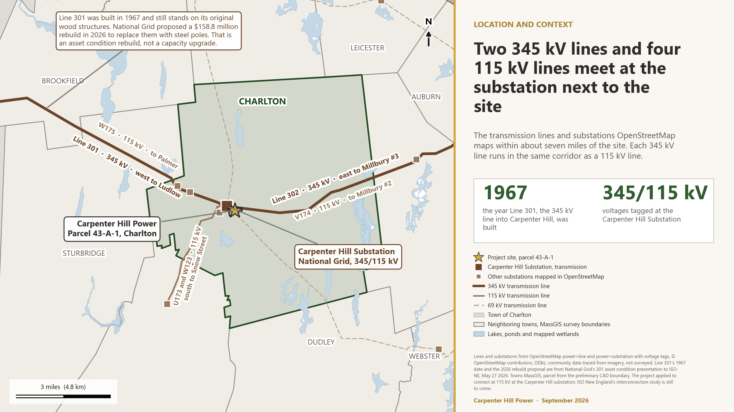
7 · How the criteria shaped the site and the design
Studies complete, in progress and not started
Complete
Critical Issues Analysis (Stantec, November 2023)
Site Suitability Mapping Tool run, July 17, 2026, on a 5.7-acre site area
MassEnviroScreen block group analysis, February 27, 2026 build
Terrain, soils and drainage analysis, September 3, 2026
Well gradient screen and well inventory within one mile, September 3, 2026
Wellhead protection desktop screen and ACEC check, September 2, 2026
Climate Resilience Design Standards Tool run, September 4, 2026
One-mile landmark map, two sheets, posted
In progress
Re-run of the Site Suitability Mapping Tool on the 17.29-acre Facility Boundary, before the Pre-filing Notice
Cumulative Impact Analysis Report
Stormwater design
Emergency Action Plan with the Charlton Fire Department, independently reviewed
Fire water source decision with the Charlton Fire Department
Sound study against the MassDEP noise policy (a preliminary screening model, not confirmed by a sound engineer, is posted; the professional study follows with the Megapack 3 data)
Viewshed or visual impact assessment (preliminary viewshed complete)
Not started, or open
Geotechnical borings, test pits and piezometers, after the pre-filing engagement period, before the Application
Field wetland delineation, after the pre-filing engagement period, before the Application, then ANRAD and Notice of Intent
MESA project review with NHESP; rare species information request being prepared for signature
Door-to-door well survey within half a mile
Environmental alternatives analysis for the Application
Traffic plan with Charlton DPW
Fire protection engineering report and hazard mitigation analysis; smoke and toxic gas plume dispersion analysis
MHC Project Notification Form; tribal consultation
Landscaping and lighting plans; magnetic field analysis; SF6 determination; SPCC Plan
FAA obstruction evaluation; Clean Water Act Section 404 applicability
980 CMR 15.10(2) to (5)
What happens next
The provisional scores become anticipated scores on the correct boundary before the Pre-filing Notice, and final scores when the Site Suitability Report is filed with the Application. Between now and then, anyone can question them.
September 10, 2026: the scores went to the Citizen Advisory Committee. Done.
September 30, 2026: Community Public Forum held at Dexter Hall, Charlton Public Library, two sessions. Done.
Before December 2026: the tool is re-run on the 17.29-acre boundary and this report is updated.
December 2026: Pre-filing Notice. February to March 2027: Application, with the final Site Suitability Report.
980 CMR 15.10
Sources, methods and terms
Every number in this report traces to a named source with a date. Where a number is a desktop measurement on published mapping rather than a survey, it says so.
Official tool run July 17, 2026; state layers pulled September 2 to 3, 2026; LiDAR 2013 to 2021.
Mapped boundaries are mapped boundaries. Survey and borings govern design.
What happens next
Questions, corrections and what comes next
September 10, 2026: the scores went to the Citizen Advisory Committee. Done.
September 30, 2026: Community Public Forum held at Dexter Hall, Charlton Public Library, two sessions. Done.
Before December 2026: the tool is re-run on the 17.29-acre boundary and this report is updated.
December 2026: Pre-filing Notice. February to March 2027: Application, with the final Site Suitability Report.
Questions about this report?
Jonathan Santiago
Project Development Associate, ESA Solar
These slides stay online atcarpenterhillpower.com/reports/site-suitability